워싱턴주로150번길
Washington State Route 150 | ||||
|---|---|---|---|---|
 SR 150은 빨간색으로 강조되어 있다. | ||||
| 경로 정보 | ||||
| 보조로97번길 | ||||
| WSDOT에 의해 유지 관리 | ||||
| 길이 | 11.76 mi[1](18.93km) | |||
| 존재했다 | 1964년-현재[2] | |||
| 주요 접점 | ||||
| 웨스트엔드 | 만손의 와파토 포인트 파크웨이 | |||
| 동쪽 끝 | ||||
| 위치 | ||||
| 나라 | 미국 | |||
| 주 | 워싱턴 | |||
| 카운티 | 첼란 | |||
| 고속도로 시스템 | ||||
| ||||
주 150번 국도(SR 150)는 미국 워싱턴 주 첼란 카운티를 운행하는 11.76마일(18.93km) 길이의 주 고속도로다.이 고속도로는 만손의 비법인 공동체에서 시작하여 첼란 호 북쪽 해안을 따라 남동쪽으로 이동하며, 첼란 호수는 미국의 97번 국도대체(US 97 Alternate)와 잠시 동시통행한다.그것은 Chelan 폭포 북쪽에 있는 콜롬비아 강에 있는 Beebe Bridge 북쪽에 있는 US 97에서 끝난다.1890년대부터 존재해 온 이 도로는 1937년 2차 주 고속도로 10C(SSH 10C)와 SSH 10D의 일부로서 서명되었다.SSH 10C는 SR 151이 되었고 SSH 10D는 1964년 고속도로 번호 변경에서 SR 150이 되었으며, 후자는 1987년에 US 97의 일부로 번호를 변경하였다.
경로 설명

SR 150은 Chelan호 북쪽 해안에 있는 Manson의 비법인 공동체의 Wapato Point Parkway와 Wapato Way의 교차점에서 시작한다.이 고속도로는 첼란 호수와 평행하게 남동쪽으로 이동하여 첼란 호수로 진입하고 남쪽으로 방향을 바꿔 레이크호어 공원을 운행한다.Chelan 내에서 SR 150은 존슨 애비뉴로 동쪽으로 이동하다가 Sunders Street로 남쪽으로 방향을 틀고 US 97 Alternate를 교차하며 Woodin Avenue로 짧은 동시 접속을 시작한다.[1]US 97 얼터너트가 갈라져 북동쪽으로 이동하며 SR 150은 첼란 폭포를 향해 남동쪽으로 계속 이어져 캐스케이드와 컬럼비아 강 철도를 건넌다.[3]이 고속도로는 콜롬비아 강에 있는 비베 다리 북쪽 97번지와의 교차로에서 끝난다.[4]
워싱턴 주 교통부(WSDOT)는 매년 주 내 고속도로에서 교통량을 측정하기 위해 일련의 조사를 실시한다.이는 연간 평균 일일 교통량(AADT)을 기준으로 표현되며, 이는 연중 평균 교통량을 측정한다.2011년 WSDOT는 하루 2300~1만대의 차량이 고속도로를 이용했다고 계산했는데, 주로 우딘 가의 첼란 다운타운에 있었다.[5]
역사
만슨 지역과 첼란을 연결하는 비포장도로는 1886년 셸란(Chelan)이 설립된 후 1890년대에 건설되었으며,[6][7] 1919년 셸란폭포까지 연장되어 새로 전용된 비베브교로 연결되었다.[8]그 초·중등 국가 고속 도로 시스템의 1937년 형성하는 동안, 맨슨에서 켈란에 이르는 길이 시큐어 셸 10C, 미국 97에 종료하고,과 시큐어 셸 10D의 켈란에서 첼랜 폭포에 이르는 길이 된 세그먼트, 미국 2시 오론도. 미국에서 북쪽 미국 97.[9][10]에 1964년 고속 도로 동안, 시큐어 셸 10C이 되면 SR150과 시큐어 셸 10번호 여행하고 있다.Dbeca나는 SR 151이다.[2][11][12]US 97은 1950년대에 제안된 [11]1987년에 Chelan폭포로 향하는 SR 151의 옛 노선으로 다시 연결되었고,[13] SR 150은 Chelan의 새로운 우회도로까지 연장되었다.[2]US 97 Alternate는 Chelan 다운타운에서 SR 150과 동시통행하게 되면서 US 97의 옛 노선에 만들어졌다.[14]WSDOT는 2017년 첼란 북서쪽 노시음도로 교차로에서 우회도로로 교차로로 교체했다.[15]
주요 교차점
전체 고속도로는 첼란 현에 있다.
| 위치 | mi[1] | km | 목적지 | 메모들 | |
|---|---|---|---|---|---|
| 맨슨 | 0.00 | 0.00 | 와파토 포인트 파크웨이 | 서부 종착역; 와파토 웨이(Wapato Way)로 계속됨 | |
| 첼란 | 7.95 | 12.79 | US 97A의 서쪽 끝 중첩 | ||
| 8.78 | 14.13 | US 97A의 동쪽 끝 중첩 | |||
| 11.76 | 18.93 | 동부 종착역 | |||
| 1.000 mi = 1.609 km, 1,000 km = 0.621 mi | |||||
참조
- ^ a b c Strategic Planning Division (March 5, 2012). State Highway Log Planning Report 2011, SR 2 to SR 971 (PDF) (Report). Washington State Department of Transportation. pp. 1076–1079. Retrieved January 16, 2013.
{{cite report}}: CS1 maint : url-status (링크) - ^ a b c "47.17.285: State route No. 150". Revised Code of Washington. Washington State Legislature. 1987 [1970]. Retrieved January 16, 2013.
- ^ 2011 Washington State Rail System (PDF) (Map). Washington State Department of Transportation. January 2012. Retrieved January 16, 2013.
- ^ Google (January 16, 2013). "State Route 150" (Map). Google Maps. Google. Retrieved January 16, 2013.
- ^ Staff (2011). "2011 Annual Traffic Report" (PDF). Washington State Department of Transportation. p. 144. Retrieved January 18, 2013.
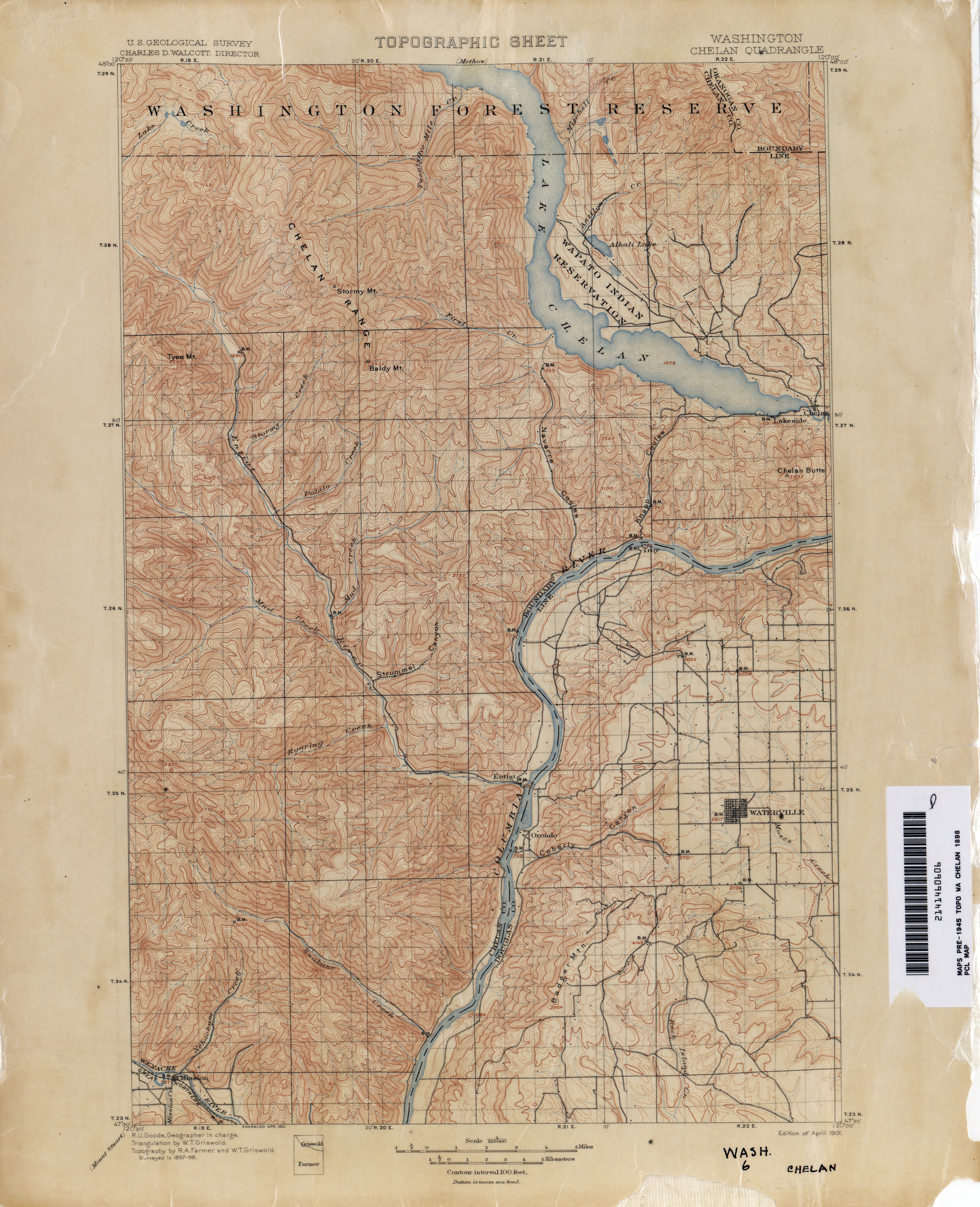
- ^ Washington: Chelan Quadrangle, 1898 (JPG) (Map). 1:125,000. United States Geological Survey. 1898. Retrieved January 18, 2013.
- ^ Caldbick, John (August 6, 2012). "Chelan, City of -- Thumbnail History". HistoryLink. Retrieved January 18, 2013.
- ^ "Beebe Bridge is Dedicated: Spans Columbia River at Chelan Station". The Spokesman-Review. October 14, 1919. Retrieved January 18, 2013.
- ^ Washington State Legislature (March 17, 1937). "Chapter 207: Classification of Public Highways". Session Laws of the State of Washington. Session Laws of the State of Washington (1937 ed.). Olympia, Washington: Washington State Legislature. p. 1007. Retrieved January 18, 2013.
(c) Secondary State Highway No. 10C; beginning at Chelan on Primary State Highway No. 10, thence in a northwesterly direction by the most feasible route to the north of Lake Chelan to Manson; (d) Secondary State Highway No. 10D; beginning at a wye junction with Primary State Highway No. 10 in the vicinity east of Chelan, thence in a southerly direction by the most feasible route crossing the Columbia river at Chelan Falls to a junction with Primary State Highway No. 2 in the vicinity of Orondo.
- ^ Highways of the State of Washington (DJVU) (Map). Department of Highways. 1939. Retrieved January 18, 2013.
- ^ a b "47.17.290: State route No. 151". Revised Code of Washington. Washington State Legislature. 1987 [1970]. Retrieved January 18, 2013.
- ^ Prahl, C. G. (December 1, 1965). "Identification of State Highways" (PDF). Washington State Highway Commission, Department of Highways. Retrieved January 18, 2013.
- ^ "Wenatchee-Pateros Highway Favored". Spokane Daily Chronicle. February 3, 1953. Retrieved January 18, 2013.
- ^ "47.17.157: State route No. 97-alternate". Revised Code of Washington. Washington State Legislature. 1987. Retrieved January 18, 2013.
- ^ Irwin, Mike (November 27, 2017). "Ribbon cutting set for No-See-Um roundabout". The Wenatchee World. Retrieved January 15, 2022.
외부 링크
경로 지도:
| KML 파일(편집 • 도움말) |
