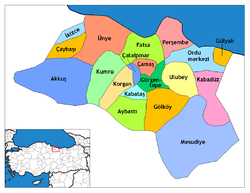
울루비, 오르두
Ulubey, Ordu울루비 | |
|---|---|
구 | |
 터키 내 울베이의 위치. | |
| 좌표: 40°53˚N 화씨 37°44°E / 40.883°N 37.733°E | |
| 나라 | |
| 지역 | 흑해 |
| 주 | 오르두 |
| 정부 | |
| • 시장 | 이샤 튀르크칸 (AKP) |
| 면적 | |
| • 지구 | 303.73km2(제곱.27제곱 mi) |
| 표고 | 602m(1,975ft) |
| 인구 (2012)[2] | |
| • 도시 | 5,290 |
| • 지구 | 16,999 |
| • 지역밀도 | 56/km2(140/sq mi) |
| 시간대 | UTC+2(EET) |
| • 여름(DST) | UTC+3(EEST) |
| 우편번호 | 52xxxx |
| 지역 번호 | 0452 |
| 번호판 | 52 |
| 기후 | cfb |
| 웹사이트 | www.ulubey.bel.tr |
울루베이는 폰틱 산맥의 흑해에서 남쪽으로 21km(13mi) 떨어진 터키 흑해 지역에 있는 오르두 성의 읍·면이다. 멜레트 강은 그 지방을 관통한다. 2000년 인구조사에 따르면 이 지역의 인구는 29,227명이고 이 중 9,128명이 울루베이에 살고 있다.[3] 그 지역은 304km2(117평방미터)의 면적에 걸쳐 있으며,[4] 그 마을은 602m(1975피트)의 고도에 위치해 있다.
이코노미
그 지역의 경제는 주로 농업에 의존한다. 헤이즐넛, 양봉, 낙농, 옥수수, 케일이 주요 생산물이다. 최근 수십 년 동안 터키의 대도시나 해외에서 사람들이 일자리를 찾아 이주함에 따라 인구는 감소해 왔으며, 지금은 주로 조부모가 남아 있다.
마을
The villages of Ulubey district include Akoluk, Akpınar, Aydınlar, Başçardak, Belenyurt, Cevizlik, Çağlayan, Çubuklu, Doğlu, Durakköy, Elmaçukuru, Eymür, Fındıklı, Güvenköy, Güvenyurt, Güzelyurt, Hocaoğlu, Kadıncık, Kalıcak, Kardeşler, Kıranyağmur, Kirazlık, Koşaca, Kumanlar, Kumrulu, Ohtamış, Oyumgürgen, Örenköy, Refahiye, Şahinkaya, Şekeroluk, Şe이흘러, 우순마흐무트, 예니사야카, 유카르ı크len렌.
메모들
- ^ "Area of regions (including lakes), km²". Regional Statistics Database. Turkish Statistical Institute. 2002. Retrieved 2013-03-05.
- ^ "Population of province/district centers and towns/villages by districts - 2012". Address Based Population Registration System (ABPRS) Database. Turkish Statistical Institute. Retrieved 2013-02-27.
- ^ Turkish Statistical Institute. "Census 2000, Key statistics for urban areas of Turkey" (in Turkish). Archived from the original (XLS) on 2007-07-22. Retrieved 2009-05-11.
- ^ Statoids. "Statistical information on districts of Turkey". Archived from the original on 2010-05-26. Retrieved 2009-05-11.
참조
- Falling Rain Genomics, Inc. "Geographical information on Ulubey, Turkey". Retrieved 2009-05-11.
외부 링크
- (터키어로) 구청장 공식 홈페이지
- (터키어로) 구 공식 홈페이지
- 울베이와 주변지역의 도로지도
- 울루베이의 다양한 이미지, 오르두
좌표: 40°52′34″N 37°44′26″E / 40.87611°N 37.74056°E/


