틴델리 어반 구
Tyldesley Urban District| 틴델리 어반 구 | |
|---|---|
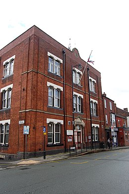
 틴델리 타운홀 | |
| 면적 | |
| • 1894 | 2690에이커(10.9km2) |
| • 1974 | 5,375에이커(21.75km2) |
| 인구 | |
| • 1911 | 15,582 |
| • 1961 | 16,813 |
| 역사 | |
| • 생성됨 | 1894 |
| • 폐지됨 | 1974 |
| • 성공자 | 위건 주의 도시 |
| 상태 | 도시구 |
| • HQ | 틴델리 타운홀 |
Tyldesley um Shakerley Urban District와 그 후계자 Tyldesley Urban District는 1894년부터 1974년까지 영국 랭커셔의 지방 정부 지역이었다.
역사
Tyldesley cum Shakerley의 읍은 역사적으로 Leigh의 큰 교회 교구에 있었고 1837년에 결성된 Leigh Poor Law Union의 일원이었다.[1][2]
1863년 Tyldesley cum Shakerley 지방정부구(Tyldesley clocal government District)는 읍이 1858년 지방정부법을 채택하면서 만들어졌다.그 도시를 통치하기 위해 지방 이사회가 구성되었다.1894년 지방정부법은 이 지역을 도시지역으로 재구성했고, 틴델리 컴 샤커리 도시구의회가 지방 이사회를 대체했다.도시 구의회는 15명의 위원으로 구성되었으며, 5개 구역을 대표하는 북, 동, 남, 서, 샤커리였다.[3] 경계에 대한 유일한 변화는 1933년 랭커셔(맨체스터와 지구) 검토령으로 이웃 리 농촌 지구에서 애슬리 시민구단이 추가되고 도시구가 틴데슬리 도시구로 개칭되면서였다.[4]1974년 Tyldesley Urban District는 1972년 지방정부법에 의해 폐지되었고 그 이전의 지역은 그레이터 맨체스터로 이전되어 위건의 메트로폴리탄 자치구의 일부가 되었다.
Tyldesley의 마을 회관은 원래 시의회의 창고와 소방서 맞은편의 Lower Eliot 가에 있었다.1924년 1881년에 문을 연 마을의 자유당 클럽은 시의회에서 마을 회관으로 사들였다.Tyldesley UDC는 1902년 Astley Street에 Tyldesley Park를 개원하고,[5] 1909년 카네기 도서관의 제공을 담당했으며, Sale Lane, Mosley Common, Shakerley에 있는 의회 주택 소유지를 담당했다.
참조
인용구
- ^ Greater Manchester Gazetteer, Greater Manchester County Record Office, Place Names T to W, archived from the original on 18 July 2011, retrieved 7 March 2010
- ^ Leigh, workhouses.org.uk, archived from the original on 5 June 2011, retrieved 3 April 2010
- ^ Farrer, William; Brownbill, J (editors) (1907), "Tyldesley with Shakerley", A History of the County of Lancaster, Volume 3, Victoria County History, pp. 439–445, retrieved 7 March 2010
{{citation}}:first2=일반 이름 포함(도움말) - ^ Great Britain Historical GIS Project (2004), "Tyldesley UD through time. Census tables with data for the Local Government District", A vision of Britain through time, University of Portsmouth, archived from the original on 4 June 2011, retrieved 7 March 2010
- ^ 룬(1953), 페이지 148.
참고 문헌 목록
- Lunn, John (1953), A Short History of the Township of Tyldesley, Tyldesley Urban District Council


