타이브로니
Tybroughney티베라기니 티오브라 파흐나 | |
|---|---|
시립 교구, 타운랜드 | |
 티베라기니 아일랜드 내 소재지 | |
| 좌표:52°20′42″n 7°21′46″w/52.344866°N 7.3626745°W좌표: 52°20°42°N 7°21°46°W / 52.344866°N 7.366745°W/ | |
| 나라 | |
| 지방 | 라인스터 |
| 자치주 | 킬케니 |
| 자치구 | 필타운[1] |
| 선거구분 | 화이트처치[2] |
| 지역 | |
| • 합계 | 4.644km2(1.793평방마일) |
| 시간대 | UTC+0(WET) |
| • 여름 (DST) | UTC-1(IST(WEST)) |
| 참조 | [3] |
Tibberaghny(아일랜드어: Tiobra Fhachna[4])는 아일랜드 킬케니 주 이버크의 남작에 있는 시민 교구이다.이 교구는 [5]티베라흐니라고도 불리는 단일 마을로 구성되어 있다.수이르 강의 북쪽 둑에 위치하고 있으며,[4] 링가운 강은 서쪽의 티퍼리 주와 분리되어 있습니다.
이름.
티오브라 파흐나라는 이름은 7세기에 [6]리스모어 수도원에 있었던 "성 파흐트나의 우물"이라는 의미이다.다양한 영어 철자법에는 Tibberaghny,[4] Tiberaghny,[7] Tipperaghny,[8] Tybroughny,[6][8] Tybroughny, Tibroughny,[7][4][7] Tibrachny가 포함됩니다.
역사
성 파흐트나 우물은 폐허가 된 옛 교구 [9]교회 근처에 마을 이름이 붙여진 신성한 우물입니다.성모돔녹은 6세기에 이 지역에서 은둔자로 살았다고 전해졌으며 [10][11]그의 축제일인 2월 13일에 성모돔녹이 그곳에서 기념되었다.이 교회는 노르만인의 아일랜드 침공 전에 세워졌고, 이 교구는 이전에는 오소리 [12]교구가 아닌 리스모르 교구에 속해 있었다.교회 마당에 있는 기둥은 켈트식 하이크로스 스타일로 조각되어 있는데,[9][13] 이 기둥의 잔재일 수 있다.아일랜드 교회에서 교구는 [14]1821년까지 화이트처치 교구로 통합되었고, 1833년에는 두 교구가 모두 [8][15]피드다운의 혜택을 받는 5개의 시민 교구 중 하나가 되었다.아일랜드 가톨릭 교회에서는 템플럼 [8]교구의 일부이다.
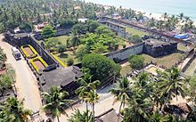
그 장소는 중세 바다를 항해하는 [6]선박들이 수이르 강 상류로 접근할 수 있는 한계점에 있다.바이킹 정착촌은 [6]980년에 파괴되었다.영국의 존 왕자는 노르만 침공 직후인 1185년 워터포드 [6]북쪽 국경을 지키기 위해 이곳에 성을 건설했다.존의 성은 15세기에 [6]지어진 현존하는 타이브로니 성 터에 지어졌을 수도 있고,[8][16] 근처에 지금은 텅 빈 높이에 모트와 베일리가 지어졌을 수도 있다.이 교구는 1536년까지 티퍼리주에 있었으나 1649년에 [17]킬케니주로 넘어갔다.
인구.
인구 조사는 1911년까지 도시별로 기록된 인구를 기록했습니다.
| 연도 | 1841 | 1851 | 1861 | 1871 | 1881 | 1891 | 1901 | 1911 |
|---|---|---|---|---|---|---|---|---|
| 인구. | 278 | 247 | 210 | 190 | 147 | 128 | 104 | 71 |
운송
Carrick-on-Suir와 Piltown 사이의 N24 도로 구간은 도시 지역의 북쪽을 관통합니다.더 남쪽에는 리메릭-로슬레어 철도 노선이 있으며, Carrick-on-Suir 역과 Waterford 역 사이에 있습니다.(더 가까운 Fiddown 역은 1964년에 폐쇄되었습니다.)[9][20]
각주
레퍼런스
- ^ "S.I. No. 53/2014 - County of Kilkenny Local Electoral Areas and Municipal Districts Order 2014". Irish Statute Book. Retrieved 29 June 2015.
- ^ a b General topographical index of Ireland, 1901. Command papers. Vol. Cd.2071. Dublin: HMSO. 1904. p. 869.
- ^ "Map with Tibberaghny highlighted". Google Maps. Retrieved 29 June 2015.
- ^ a b c d "Tiobra Fhachna/Tibberaghny (parish)". Placenames Database of Ireland. Retrieved 29 June 2015.
- ^ "Tiobra Fhachna/Tibberaghny (townland)". Placenames Database of Ireland. Retrieved 29 June 2015.
- ^ a b c d e f "Tybroughney Castle - Bastion of Romans and saints and now restored by the Dowleys". Kilkenny People. 10 October 2012. Retrieved 29 June 2015.
- ^ a b c Abstract of Answers and Returns pursuant to Act for taking Account of Population of Ireland. Command papers. Vol. 22, xxiv, 393. HMSO. 1824. pp. 71, note (y).
- ^ a b c d e Lewis, Samuel (1837). "Tipperaghney". A Topographical Dictionary of Ireland. Retrieved 29 June 2015.
- ^ a b c Crawford, Henry S. (30 September 1908). "Description of a Carved Stone at Tybroughney, Co. Kilkenny". The Journal of the Royal Society of Antiquaries of Ireland. Fifth Series, Vol. 38 (3): 270–277. JSTOR 25513927.
- ^ Bunson, Matthew; Bunson, Margaret; Bunson, Stephen (2003). "Modomnoc". Our Sunday Visitor's Encyclopedia of Saints. Our Sunday Visitor Publishing. p. 592. ISBN 9781931709750. Retrieved 30 June 2015.
- ^ "St Aidan, Bishop and Patron of Ferns". The Irish Ecclesiastical Record. Browne and Nolan. 7 (73): 394. 1871.
- ^ Power, P. (30 June 1938). "Some Old Churches of Decies". The Journal of the Royal Society of Antiquaries of Ireland. Seventh Series, Vol. 8 (1): 56, fn.1. JSTOR 25510095.
- ^ Kelly, Dorothy (1992). "The High Crosses of Ireland: A Review Article". The Journal of the Royal Society of Antiquaries of Ireland. 122: 69. JSTOR 25509022.
- ^ "County Kilkenny: Barony of Iverk". Abstract of Answers and Returns pursuant to Act for taking Account of Population of Ireland. Sessional papers. Vol. 22 xxiv 577. 1824. pp. 44–45, note (y). Retrieved 30 June 2015.
- ^ "Return of Number of Churches in each Benefice or Union in Ireland". Sessional papers No.400. EPPI. 18 June 1833. pp. 14 No.34. Retrieved 30 June 2015.
- ^ Orpen, Goddard H. (31 December 1909). "Motes and Norman Castles in Ossory". The Journal of the Royal Society of Antiquaries of Ireland. 39 [Fifth Series, Vol. 19] (4): 324. JSTOR 25514022.
- ^ Empey, C. A. (1971). "The Cantreds of the Medieval County of Kilkenny". The Journal of the Royal Society of Antiquaries of Ireland. Royal Society of Antiquaries of Ireland. 101 (2): 131. JSTOR 25549764.
- ^ "HISTPOP.ORG - Browse > Census > 1881 > Ireland > Area, population and number of houses, Vol. I, Ireland, 1881 Page 342". Retrieved 30 June 2015.
- ^ "HISTPOP.ORG - Browse > Census > 1911 > Ireland > Area, houses, and population, Leinster, Ireland, 1911 Page 15". Retrieved 30 June 2015.
- ^ "Written Answers. - River Suir Bridge". Dáil Éireann debates. 29 March 1977. Retrieved 30 June 2015.