무산담 반도
Musandam Peninsula| جَزِيْرَة مُسَنْدَم رَأْس مُسَنْدَم | |
|---|---|
 우주에서 본 반도. 녹색으로 표시된 북쪽(상단)의 알카삽은 이 거짓 색채 이미지에서 주변 바위의 더욱 은은한 무지개 톤과 대비된다. 카삽이라는 용어는 토양의 다산을 가리킨다. | |
| 좌표: 좌표: 25°54′N 56°12′E / 25.900°N 56.200°E/ | |
| 오만과 아랍에미리트의 행정 구역 | 무산담 주(오만) 라스 알카이마 (UAE) |
The Musandam Peninsula (Arabic: جَزِيْرَة مُسَنْدَم \ رَأْس مُسَنْدَم, romanized: Jazīrat Musandam / Raʾs Musandam), locally known as Ruus Al Jibal (Arabic: رُؤُوْس ٱلْجِبَال, romanized: 루주스 알 지바엘 산맥의 머리들)[3]은 아라비아 반도의 북동쪽 지점을 이루는 반도다. 페르시아 만과 오만 만 사이에 있는 호르무즈 해협 남쪽에 위치해 있다.[4] 시후족이 거주하고 있으며, 무산담 총독으로서 오만이 주로 통치하고 있으며, 라스 알 카이마, 디브바 일부 등 아랍에미리트가 통치하는 일부 지역이 있다.[1][2]
기후, 지질학, 지리학
육지 특징으로는 서하르 산맥을 들 수 있다. 이들은 하자르 산맥의 최북단이기 때문에 이들 산맥과 반도를 루슈스 알 지바울(아랍어: رُؤوسسسسس roman, 로마자로 표기)이라고 한다. 산의 머리들).[1][2] 와디스는 Bih의 그것까지 포함한다.[5][6]
아랍에미리트에서 가장 높은 지점은 해발 1,934m(6,345ft)의 라스 알카이마 인근 제벨자이스(Jebel Jais)에 위치해 있지만,[7] 그 봉우리가 오만 쪽에 있기 때문에 자발 이비르(Jabal Yibir)는 1527m(0.949mi)의 아랍에미리트에서 가장 높은 봉우리를 차지하고 있다.[8]
겨울에는 특히 야나스 자이스의 산지(아랍어: نسن; 25; 25°44″12 56N 56°5)가 상당히 서늘할 수 있다.′56″E / 25.73667°N 56.09889°E/ ) 및 Yibir.[9][10]

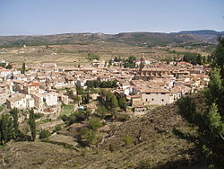
1971년 12월 무산담 산경

자발 치휘의 루우스 알 지발 보기

금자르 산지, 1908년

.jpg)


| .jpg)
 | |||||||||||||||||||||||||||||||||||||||||||||||||||||||


동식물
Fauna는 루스 알 지발 도마뱀붙이,[11] 아라비아 타흐르, 카라칼을 포함한다. 아라비아 표범이 아직 존재하는지 알 수 없다.[1][2]

무산담 주 즈하이만의 아프리카 군주 나비(다나우스 크리시푸스)

푸른바스커잠자리 (우로테미스 에드워드시이)

커먼 마이나 (아크리다테레스 트리스티스)

집참새(패서내과)
.jpg)
.jpg)
.jpg)
.JPG)
_(12801641984).jpg)
참고 항목
참조
- ^ a b c d Edmonds, J.-A.; Budd, K. J.; Al Midfa, A. & Gross, C. (2006). "Status of the Arabian Leopard in United Arab Emirates" (PDF). Cat News (Special Issue 1): 33–39.
- ^ a b c d Spalton, J. A. & Al-Hikmani, H. M. (2006). "The Leopard in the Arabian Peninsula – Distribution and Subspecies Status" (PDF). Cat News (Special Issue 1): 3–47.
- ^ Thomas, B. (March 1927). Travels in Oman. Visit of B. Thomas to the Musandam Peninsula. 1928. Notes on Shihuh dialects & people, also Kumzaris' [10r]. British Library: India Office Records and Private Papers. p. 9.
- ^ Diba, B. A. (2011). Is Iran legally permitted to close Strait of Hormuz to countries that impose sanctions against Iran's oil?. Cupertino, California: Payvand Iranian-American Website.
- ^ Lancaster, Fidelity; Lancaster, William (2011). Honour is in Contentment: Life Before Oil in Ras Al-Khaimah (UAE) and Some Neighbouring Regions. Berlin, New York: Walter de Gruyter. pp. 3–598. ISBN 978-3-1102-2339-2.
- ^ Allen, Calvin H., Jr. (2016-02-05). "1: Land and People". Oman: the Modernization of the Sultanate. Abingdon, New York: Routledge. pp. 1–8. ISBN 978-1-3172-9164-0.
- ^ "Jebel Jais". Jebel Jais Ras Al Khaimah. Retrieved 5 December 2017.
- ^ "Jabal Yibir". Dangerousroads.org. Retrieved 2019-02-12.
- ^ Al Serkal, Mariam M. (2019-03-10). "UAE to see cold days ahead, temperatures drop to 2.6°C". Gulf News. Retrieved 2019-03-17.
- ^ Al Serkal, Mariam M. (2019-02-28). "UAE to get 5 days of rain and "significant drop in temperature"". Gulf News. Retrieved 2019-03-17.
- ^ Simó-Riudalbas, M.; Metallinou, M.; De Pous, P.; Els, J.; Jayasinghe, S.; Péntek-Zakar, E.; Wilms, Thomas; Al-Saadi, Saleh; Carranza, Salvador (2017-08-02), "Cryptic diversity in Ptyodactylus (Reptilia: Gekkonidae) from the northern Hajar Mountains of Oman and the United Arab Emirates uncovered by an integrative taxonomic approach", PLOS ONE, 12 (8): e0180397, Bibcode:2017PLoSO..1280397S, doi:10.1371/journal.pone.0180397, PMC 5540286, PMID 28767644, e0180397