카제룬 현
Kazerun County카제룬 현 페르시아어: | |
|---|---|
자치주 | |
 카제룬의 풍경 | |
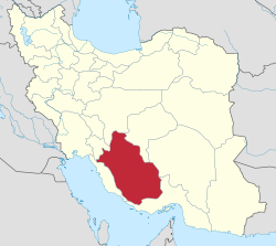
 파르스 주 카제룬 군의 위치 | |
 이란의 파르스 지방 위치 | |
| 좌표 : 29°29′N 51°39′E / 29.483°N 51.650°E[1] | |
| 나라 | |
| 지방 | 파르스 |
| 자본의 | 카제룬 |
| 구 | 중부와 예루살렘과 발라데, 케싯과 코나르다흐테와 카마라지, |
| 인구. (2016)[2] | |
| • 토탈 | 266,217 |
| 시간대 | UTC+3:30 (IRST) |
| Kazerun County는 GEOnet Names Server, 이 링크에서 고급 검색 상자를 열고 "Unique Feature Id" 양식에 "9206551"을 입력한 후 "Search Database"를 클릭하면 찾을 수 있습니다. | |
카제룬 현(페르시아어: شهرستان کازرون)은 이란 파르스 지방에 있습니다. 수도는 카제룬 시입니다.
2006년 인구 조사에서 이 지역의 인구 수는 58,036가구 258,097명이었습니다.[3] 다음의 인구 조사는 2011년 67,262 가구의 254,704명을 집계했습니다.[4] 2016년 기준으로 이 지역의 인구 수는 총 266,217명입니다.[2]
행정 구역
3개의 연속적인 인구 조사에 의한 카제룬 현의 행정 구역의 인구 역사와 구조 변화는 다음 표와 같습니다. 최근의 인구 조사는 6개의 구, 14개의 농촌 구, 6개의 도시를 보여줍니다.[2]
2018년 쿠마레 향, 솜한 향, 나우단 향, 콰미예 향이 쿠체나르 현에서 분리되었습니다.[5]
| 행정 구역 | 2006[3] | 2011[4] | 2016[2] |
|---|---|---|---|
| 센트럴 디스트릭트 | 128,945 | 133,860 | 142,057 |
| 애너스티안 RD | |||
| 발리안 RD | 17,089 | 17,468 | 17,476 |
| Dasht-e Barm RD | |||
| 데리스 RD | 20,503 | 20,818 | 21,785 |
| 샤퍼RD | 6,759 | 5,889 | 6,113 |
| 카제룬(도시) | 84,594 | 89,685 | 96,683 |
| 셰나르샤히잔 구 | 42,975 | 43,399 | 45,638 |
| 애너스티안 RD1 | 11,070 | 9,610 | 9,628 |
| 솜한RD2 | 8,171 | 8,434 | 9,092 |
| emi미예(시) | 23,734 | 25,355 | 26,918 |
| 제레발라데 구 | 37,315 | 34,234 | 35,524 |
| 다딘 RD | 8,556 | 6,962 | 7,341 |
| 향료 RD | 9,873 | 8,658 | 8,220 |
| 제레르 알디 | 14,950 | 14,371 | 13,991 |
| 발라샤르 (도시)3 | 3,936 | 4,243 | 5,972 |
| 케쉬트 구 | 14,528 | 15,275 | |
| 부라키 RD | 3,368 | 3,685 | |
| 엠마자데 모하마드 RD | 2,052 | 1,991 | |
| 케쉬트 (도시) | 9,108 | 9,599 | |
| 코나르타흐테 구4 | 30,227 | 10,717 | 11,273 |
| 카마라즈 RD | 4,528 | 4,171 | 4,406 |
| 코나르타흐테흐 RD5 | 8,677 | 1,068 | 786 |
| 케쉬트 (도시) | 10,332 | ||
| 코나르타흐테 (도시) | 6,690 | 5,478 | 6,081 |
| 쿠마레 구 | 18,635 | 17,156 | 16,079 |
| Dasht-e Barm RD1 | 6,690 | 5,941 | 6,135 |
| Kuhmareh RD2 | 9,356 | 8,641 | 7,052 |
| 노우단(도시)2 | 2,589 | 2,574 | 2,892 |
| 총 | 258,097 | 254,704 | 266,217 |
| RD: 농촌 지역 2016년 인구조사[5] 이후 중부지구의 1일부가 되었습니다. 2016년 인구조사[5] 이후 쿠체나르 현의 2일부가 됨 3구 발라데[6] 4케쉬트카마라즈[7] 구 5케쉬트[7] 구 | |||
지리적 위치
동쪽으로는 시라즈 현, 북쪽으로는 쿠체나르 현, 서쪽과 남쪽으로는 부셰르 주, 남동쪽으로는 파라슈반드 현과 접합니다.[8][9]
Wikimedia Commons에는 Kazerun County와 관련된 미디어가 있습니다.
대학 및 고등 교육 센터
Kazerun에서는 명성, 연구 성과 및 동문 영향력을 기준으로 Kazerun 내 최고의 두 대학이 순위를 매깁니다.[10]
1. 살만 파르시 카제룬 대학교
2. 카제룬 이슬람 아자드 대학교
참고문헌
- ^ OpenStreetMap contributors (21 September 2023). "Kazerun County" (Map). OpenStreetMap. Retrieved 21 September 2023.
- ^ a b c d "Census of the Islamic Republic of Iran, 1395 (2016)". AMAR (in Persian). The Statistical Center of Iran. p. 07. Archived from the original (Excel) on 6 April 2022. Retrieved 19 December 2022.
- ^ a b "Census of the Islamic Republic of Iran, 1385 (2006)". AMAR (in Persian). The Statistical Center of Iran. p. 07. Archived from the original (Excel) on 20 September 2011. Retrieved 25 September 2022.
- ^ a b "Census of the Islamic Republic of Iran, 1390 (2011)" (Excel). Iran Data Portal (in Persian). The Statistical Center of Iran. p. 07. Retrieved 19 December 2022.
- ^ a b c Jahangiri, Ishaq (10 July 2018). "Letter of approval regarding country divisions of Kazerun County of Fars province". Qavanin (in Persian). Ministry of Interior, Board of Ministers. Archived from the original on 21 September 2023. Retrieved 21 September 2023.
- ^ "The name of the city of Baladeh in Kazerun County was officially changed to Valashahr". Khabar Farsi (in Persian). Ministry of Interior, Board of Ministers. Archived from the original on 22 September 2023. Retrieved 22 September 2023.
- ^ a b Davodi, Parviz (9 October 2013). "Letter of approval regarding the changes and reforms of divisions in Fars province". Qavanin (in Persian). Ministry of Interior, Political and Defense Commission. Archived from the original on 21 September 2023. Retrieved 21 September 2023.
- ^ Foundation, Encyclopaedia Iranica. "Welcome to Encyclopaedia Iranica". iranicaonline.org. Retrieved 28 January 2023.
- ^ "Where is the geographical location of Kazerun?". Bing. Retrieved 28 January 2023.
- ^ "2 Best Universities in Kazerun [2023 Rankings]". EduRank.org - Discover university rankings by location. 21 November 2019. Retrieved 28 January 2023.


