케나드사
Kénadsa케나드사 ﻗﻨﺎدﺳﺔ | |
|---|---|
코뮌과 타운 | |
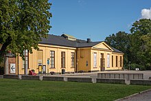
.jpg) 케나드사의 눈 | |
 베차르 주 내 케나드사 코뮌의 위치 | |
 케나드사 알제리 내 케나드사의 위치 | |
| 좌표:31°32˚N 2°25˚W/31.533°N 2.417°W좌표: 31°32′N 2°25′W / 31.533°N 2.417°W/ | |
| 나라 | |
| 주 | 베차르 주 |
| 구 | 케나드사 구 |
| 정부 | |
| • 시장 | 모하메드 메트라니 |
| 면적 | |
| • 합계 | 2,770 km2 (1,070 sq mi) |
| 표고 | 784m(2,572ft) |
| 인구 (2008)[2] | |
| • 합계 | 13,492 |
| • 밀도 | 4.9/km2(13/sq mi) |
| 시간대 | UTC+1(CET) |
케나드사는 알제리 남서부의 사하라 사막에 있는 마을이자 코뮌으로 베차르 주 케나드사 구의 수도다.2008년 현재 케나드사의 인구는 [2]1만3492명으로 1998년 1만1667명보다 증가했으며,[3] 연평균 성장률은 1.5%에 이른다.그 공동체의 면적은 2,770 평방 킬로미터 (1,070 평방 미)이다.[1]
케나드사 근처에 큰 장파방송국이 있다.
지리
케나드사는 베차르 서쪽의 평평한 바위 하마다에서 784미터(2,572피트)의 높이에 있다.와디 오에드 메스워는 마을에서 서쪽으로 약 6km(3.7mi) 떨어진 곳에 위치하고 있으며, 크시 코우(Ksi Ksou)의 지역인 아바들라 인근 오에드 기르(Oued Guir)와 만난다.
기후.
케나드사는 뜨거운 사막 기후(Köppen: BWh)를 가지고 있으며,[4] 극도로 더운 여름과 온화한 겨울, 일년 내내 강수량이 거의 없다.
| 케나드사의 기후 데이터 | |||||||||||||
|---|---|---|---|---|---|---|---|---|---|---|---|---|---|
| 월 | 얀 | 2월 | 3월 | 4월 | 5월 | 준 | 줄리 | 8월 | 9월 | 10월 | 11월 | 12월 | 연도 |
| 평균 높은 °C(°F) | 15.9 (60.6) | 19.2 (66.6) | 22.5 (72.5) | 27.1 (80.8) | 31.4 (88.5) | 36 (97) | 40.5 (104.9) | 39.4 (102.9) | 34.3 (93.7) | 27.5 (81.5) | 20.4 (68.7) | 16.8 (62.2) | 27.6 (81.7) |
| 일평균 °C(°F) | 8.9 (48.0) | 12 (54) | 15.4 (59.7) | 19.9 (67.8) | 24.1 (75.4) | 28.8 (83.8) | 33 (91) | 32.2 (90.0) | 27.4 (81.3) | 20.7 (69.3) | 14.2 (57.6) | 9.9 (49.8) | 20.5 (69.0) |
| 평균 낮은 °C(°F) | 2 (36) | 4.8 (40.6) | 8.4 (47.1) | 12.7 (54.9) | 16.8 (62.2) | 21.6 (70.9) | 25.5 (77.9) | 25 (77) | 20.5 (68.9) | 14 (57) | 8 (46) | 3.1 (37.6) | 13.5 (56.3) |
| 평균 강수량 mm(인치) | 9 (0.4) | 8 (0.3) | 9 (0.4) | 8 (0.3) | 5 (0.2) | 4 (0.2) | 1 (0.0) | 3 (0.1) | 7 (0.3) | 12 (0.5) | 12 (0.5) | 10 (0.4) | 88 (3.6) |
| 출처: Climate-Data.org, 고도: 750m[4] | |||||||||||||
이코노미

케나드사에서 농업은 중요한 산업이다.이 코뮈니케는 총 1,850헥타르(4,600에이커)의 경작지를 보유하고 있지만 관개용지는 150헥타르(370에이커)에 불과하다.[5]총 6만7000개의 대추야자(대추야자)가 공단에 심어져 있다.[6]2009년 현재 양 3757마리, 염소 4592마리, 낙타 1507마리, 소 163마리가 있다.또한 22개 건물에 4천 마리의 닭이 있었다.[7]
케나드사에는 약간의 관광이 있다; 볼거리로는 모래언덕, 야자수 숲, 오래된 까르와 요새, 그리고 외드 메스워 건너편의 댐이 있다.[8]케나드사에는 호텔이 없기 때문에 케나드사를 방문하는 사람들은 일반적으로 베샤르에 머문다.[9]
케나드사 인근에는 유연탄밭도 있다.그것들은 원래 1907년에 발견되었지만 1917년에야 채굴 활동이 시작되었다.생산량은 1940년대에 정점을 찍었고 이후 알제리 동부의 석유와 가스전과의 경쟁으로 인해 감소해왔다.인근에는 납, 망간, 철광석 등의 퇴적물도 있지만 이것들은 대부분 사용되지 않고 있다.[10]
인프라 및 주택
케나드사 인구의 100%가 식수와[11] 하수도로 연결돼 있으며 97%(2,707개 건물 포함)가 전기에 접근할 수 있다.[12][13]그 마을에는 두 개의 주유소가 있다.[14]
케나드사는 총 2,613채의 주택을 보유하고 있으며, 이 중 2,142채가 입주해 있어 입주 건물당 6.3명의 입주율을 보이고 있다.[15]
교통
케나드사는 서쪽으로는 메리드자와 동쪽으로는 베샤르를 잇는 지방도에 놓여 있다.케나드사는 베차르에서 20km(12mi), 메리드자에서 60km(37mi) 떨어져 있다.[16]
코뮌에는 총 64.4km(40.0mi)의 도로가 있다.[17]
교육
초등학교는 4개교로 48개교 등 65개교실이 운영되고 있다.[18]총 2,562명의 학생들이 있다.[19]
인구의 7.2%가 3차 교육을 받았으며, 또 다른 22.6%는 중등교육에 참가하였다.[20]전체 문해율은 84.6%로 남성 91.2%, 여성 78.2%로 나타났다.[21]
건강
케나드사는 5개의 객실 관리 시설과 산부인과 병동을 갖추고 있으며, 다른 건강 관리 시설 거주자들은 베샤르로 이동해야 한다.[22]
문화
케나드사는 350석의 영화관을 가지고 있다.[23]
케나드사에서 태어난 저명한 작가로는 야스미나 카드라, 말리카 모케드뎀, 피에르 라비 등이 있다.
종교
케나드사는 3개의 모스크를 운영하고 있으며, 다른 2개의 모스크는 건설 중이다.[24]
지역
이 공동체는 세 개의 지역으로 구성되어 있다.[25]
- 케나드사
- 바라지 조프 토바
- 마스키
참조
- ^ a b "Population, Area and Density per Commune" (in French). Official Website of the Wilaya of Bechar. Archived from the original on 22 February 2014. Retrieved 16 March 2013.
- ^ a b "Population: Béchar Wilaya" (PDF) (in French). Office National des Statistiques Algérie. Archived from the original (PDF) on 16 May 2013. Retrieved 13 February 2013.
- ^ "Algeria Communes". Statoids. Retrieved 9 March 2013.
- ^ a b "Climate: Kenadsa - Climate graph, Temperature graph, Climate table". Climate-Data.org. Retrieved 5 November 2013.
- ^ "Distribution of Agricultural Land" (in French). Official Website of the Wilaya of Bechar. Archived from the original on 10 July 2014. Retrieved 9 March 2013.
- ^ "Plant Productions" (in French). Official Website of the Wilaya of Bechar. Archived from the original on 20 August 2014. Retrieved 9 March 2013.
- ^ "Animal Production" (in French). Official Website of the Wilaya of Bechar. Archived from the original on 20 August 2014. Retrieved 9 March 2013.
- ^ "Tourist Sites and Monuments" (in French). Official Website of the Wilaya of Bechar. Archived from the original on 4 March 2016. Retrieved 9 March 2013.
- ^ "Census of Hotels" (in French). Official Website of the Wilaya of Bechar. Archived from the original on 23 January 2016. Retrieved 9 March 2013.
- ^ "Kenadsa (town and coalfields, Algeria)". Encyclopædia Britannica. Retrieved 10 March 2013.
- ^ "Drinking Water" (in French). Official Website of the Wilaya of Bechar. Archived from the original on 9 July 2014. Retrieved 9 March 2013.
- ^ "Sewerage Networks" (in French). Official Website of the Wilaya of Bechar. Archived from the original on 10 July 2014. Retrieved 9 March 2013.
- ^ "Electrification" (in French). Official Website of the Wilaya of Bechar. Archived from the original on 9 July 2014. Retrieved 9 March 2013.
- ^ "Fuel Distribution" (in French). Official Website of the Wilaya of Bechar. Archived from the original on 10 July 2014. Retrieved 9 March 2013.
- ^ "Housing" (in French). Official Website of the Wilaya of Bechar. Archived from the original on 4 March 2016. Retrieved 9 March 2013.
- ^ "Presentation" (in French). Site Officiel de la Wilaya de Béchar. Archived from the original on 16 February 2013. Retrieved 19 February 2013.
- ^ "Density Kilometres" (in French). Official Website of the Wilaya of Bechar. Archived from the original on 29 April 2014. Retrieved 9 March 2013.
- ^ "School Infrastructure" (in French). Official Website of the Wilaya of Bechar. Archived from the original on 29 April 2014. Retrieved 9 March 2013.
- ^ "Number of Pupils" (in French). Official Website of the Wilaya of Bechar. Archived from the original on 4 March 2016. Retrieved 9 March 2013.
- ^ "Structure relative de la population résidente des ménages ordinaires et collectifs âgée de 6 ans et plus selon le niveau d'instruction et la commune de résidence" (PDF) (in French). Office National des Statistiques Algérie. Archived from the original (PDF) on 17 May 2013. Retrieved 13 February 2013.
- ^ "Taux d'analphabétisme et taux d'alphabétisation de la population âgée de 15 ans et plus, selon le sexe et la commune de résidence " (PDF) (in French). Office National des Statistiques Algérie. Archived from the original (PDF) on 16 May 2013. Retrieved 13 February 2013.
- ^ "Health Facilities by Commune" (in French). Official Website of the Wilaya of Bechar. Archived from the original on 29 April 2014. Retrieved 9 March 2013.
- ^ "Cinemas and Museums" (in French). Official Website of the Wilaya of Bechar. Archived from the original on 23 January 2016. Retrieved 9 March 2013.
- ^ "Mosques and Koranic Rooms" (in French). Official Website of the Wilaya of Bechar. Archived from the original on 4 March 2016. Retrieved 9 March 2013.
- ^ "Décret n° 84-365, fixant la composition, la consistance et les limites territoriale des communes. Wilaya d'El Oued" (PDF) (in French). Journal officiel de la République Algérienne. 19 December 1984. p. 1489. Archived from the original (PDF) on 21 October 2013. Retrieved 2 March 2013.
.svg)