하토 레이 센트럴
Hato Rey Central하토 레이 센트럴 | |
|---|---|
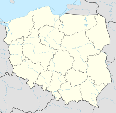
 노란색으로 표시된 하토 레이 센트럴의 위치. | |
| 좌표:18°25′19″n 66°03′02″w/18.421854°N 66.05052°W좌표: 18°25′19″N 66°03′02″W / 18.421854°N 66.05052°W[1] | |
| 영연방 | |
| 시 | |
| 면적 | |
| • 합계 | 1.04 sq mi(2.7 km2) |
| • 육지 | 1.03 sq mi(2.7 km2) |
| • 물 | 0.01 sq mi(0.03km2) |
| 표고 | 23피트(7m) |
| 인구 (2010) | |
| • 합계 | 16,640 |
| • 밀도 | 16,1987.3/sq mi(6,237.6/km2) |
| 2010년 인구 조사 | |
하토 레이 센트럴은 푸에르토리코 산후안 시의 18개 바리오 중 하나이다.평방 마일당 인구 밀도가 16,155.3이다.국토면적은 1.03제곱 mi이고 2010년 인구총조사 인구는 16,640명이다.[3]
하토 레이 센트럴은 1951년 산후안과 합병되기 전까지 리오 피에드라스 구 시의 바리오였다.
서쪽으로는 하토 레이 노르트, 남쪽으로는 바리오 우니베르시다드, 동쪽으로는 오리엔테, 북쪽으로는 산투르체(Santurce)로 경계를 이룬다.카뇨 마르틴 페냐는 하토 레이 센트럴과 산투르스를 분리한다.
인구통계학
| 역사인구 | |||
|---|---|---|---|
| 인구조사 | Pop. | %± | |
| 1980 | 23,246 | — | |
| 1990 | 22,504 | −3.2% | |
| 2000 | 20,867 | −7.3% | |
| 2010 | 16,640 | −20.3% | |
| 미국 십수년 인구[4] 조사 1899년 (1990년 ~[5] 1900년) 1910년[6] 1930-1950[7] 1980-2000[8] 2010[9] | |||
바리오의 인구는 16,640명으로 인구밀도는 평방마일당 16,155명이다.[3]
구
하토 레이 센트럴(Hato Rey Central)의 바리오(Barrio)는 북쪽부터 남쪽까지 [10]4개의 서브바리오로 더 나뉜다.[11]
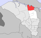
라스 몬하스

시우다드누에바
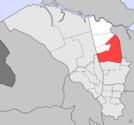
퀸타나
.png)
.png)
.png)
.png)
랜드마크 및 관심장소
- 마르틴 페냐 다리(하토 레이 노르테와 공유), 하토 레이 센트럴과 산투르스를 잇는 아트 데코 스타일의 다리.
- 산후안의 중심 상권인 밀라 데 오로.
- 푸에르토리코 폴리테크닉 대학의 메인 캠퍼스.
교통
트렌 우르바노 역은 기술적으로 하토 레이 센트럴에 위치해 있지 않지만, 피녜로, 도메네치, 루즈벨트, 하토 레이 지하철 역은 바리오와 매우 가까운 곳에 위치해 있다(일부 경우에는 심지어 한 발짝도 떨어져 있다).이 지역은 또한 메트로폴리탄 버스 당국(AMA)이 운행하고 있다.
갤러리

라스 몬하스 구
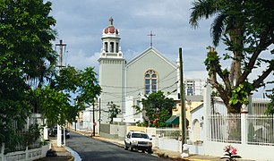
플로랄 공원 구역의 에스피리투 산토 패리쉬

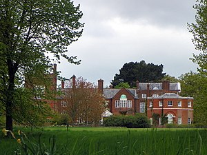
푸에르토리코 폴리테크닉 대학교

폴리테크닉 대학교 도서관


참고 항목
참조
- ^ a b "US Gazetteer 2019". US Census. US Government.
- ^ 미국 지질조사국 지리적 이름 정보 시스템:하토 레이 센트럴 바리오
- ^ a b Puerto Rico: 2010:population and housing unit counts (PDF). U.S. Dept. of Commerce, Economics and Statistics Administration, U.S. Census Bureau. 2010.
- ^ "U.S. Decennial Census". United States Census Bureau. Archived from the original on February 13, 2020. Retrieved September 21, 2017.
- ^ "Report of the Census of Porto Rico 1899". War Department Office Director Census of Porto Rico. Archived from the original on July 16, 2017. Retrieved September 21, 2017.
- ^ "Table 3-Population of Municipalities: 1930 1920 and 1910" (PDF). United States Census Bureau. Archived (PDF) from the original on August 17, 2017. Retrieved September 21, 2017.
- ^ "Table 4-Area and Population of Municipalities Urban and Rural: 1930 to 1950" (PDF). United States Census Bureau. Archived (PDF) from the original on August 30, 2015. Retrieved September 21, 2014.
- ^ "Table 2 Population and Housing Units: 1960 to 2000" (PDF). United States Census Bureau. Archived (PDF) from the original on July 24, 2017. Retrieved September 21, 2017.
- ^ Puerto Rico:2010:population and housing unit counts.pdf (PDF). U.S. Dept. of Commerce Economics and Statistics Administration U.S. Census Bureau. 2010. Archived (PDF) from the original on 2017-02-20. Retrieved 2019-08-02.
- ^ "US Census definition of "subbarrio"". factfinder.com. US Census. Archived from the original on 12 February 2019. Retrieved 5 January 2019.
- ^ "Archived copy" (PDF). Archived from the original (PDF) on 2017-07-24. Retrieved 2019-02-11.
{{cite web}}: CS1 maint: 타이틀로 보관된 사본(링크)
이 푸에르토리코 산후안 지역 기사는 단조롭다.위키피디아를 확장하여 도울 수 있다. |