텔이츠하크
Tel Yitzhak텔이츠하크 תֵּל יִצְחָק | |
|---|---|
 | |
 텔이츠하크 | |
| 좌표: 32°15′8.64″N 34°52′8.76″E / 32.2524000°N 34.8691000°E좌표: 32°15′8.64″N 34°52′8.76″E / 32.2524000°N 34.8691000°E/ | |
| 나라 | 이스라엘 |
| 구 | 중앙 |
| 의회 | 호프 하샤론 |
| 소속 | 하오베드 하치오니 |
| 설립됨 | 1938 |
| 설립자: | 갈리시아인 유대인 |
| 인구 (2019)[1] | 1,021 |
텔 이츠하크(헤브루: תֵּלל lit lit lit lit lit, light. 이츠하크 언덕)은 이스라엘 중부에 있는 키부츠다. 네탄야 남동쪽 해안 평야에 위치하며 호프 하샤론 지역 평의회의 관할에 속한다. 2019년에는 1,021명의 인구를 가지고 있었다.[1]
역사
포레그 강의 습지와 접해 있는 텔이츠하크 지역은 중후반 청동기 시대(17~13세기), 비잔틴 시대(4~7세기), 오스만 후기(19~20세기 초) 등 구석기 시대부터 간헐적으로 거주하고 있다.[2]
키부츠는 1938년 갈리시아에서 온 시오니스트 장군에[3] 의해 탑과 스타케이드 정착 운동의 일환으로 설립되었다. 갈리시아에 있는 하노아르 하치오니의 지도자 이츠하크 슈타이거의 이름을 따서 지은 것이다.

하레츠 신문사, 텔 이츠하크
유대인 대학살 연구와 기념의 중심지인 마수아는 키부츠에 설립되었다.[4]
자연보호구역
키부츠의 남서쪽은 샤론 평원이 원산지인 동식물군을 보호하기 위해 1968년에 설립된[5] 8두남 자연보호구역이다.[6] 플로라에는 세라토니아 규혈아, 칼리코토메 빌로사, 티멜라에아 히르수타, 프라시움 마지우스, 아나기리스, 라반둘라 스토아스가 포함된다.
역사적 이미지

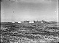
1938년 감시탑의 텔 이츠하크 건설

텔 이츠하크 성벽 건설, 1938년 7월
텔 이츠하크 1939

텔 이츠하크 1944년 1:20,000 (오른쪽 하단 사분면:텔 이츠하크)


참조
- ^ a b "Population in the Localities 2019" (XLS). Israel Central Bureau of Statistics. Retrieved 16 August 2020.
- ^ Marom, Roy (2008). From Time Immemorial: Chapters in the History of Even Yehuda and its Region in Light of Historical and Archaeological Research (Hebrew) \ מימי קדם קדמתה: פרקים בתולדות אבן יהודה וסביבתה לאור המחקר ההיסטורי והארכיאולוגי.
- ^ Dov Levin (2000). The Litvaks: A Short History of the Jews in Lithuania. Yad Vashem Jerusalem. p. 162. ISBN 9781571812643.
- ^ Berenbaum, Michael; Peck, Abraham J., eds. (2002). The Holocaust and History: The Known, the Unknown, the Disputed, and the Reexamined. Bloomington, Indiana: Indiana University Press. p. 797. ISBN 0-253-21529-3.
- ^ "List of National Parks and Nature Reserves" (PDF) (in Hebrew). Israel Nature and Parks Authority. Archived from the original (PDF) on October 7, 2009. Retrieved 2010-09-27.
- ^ "Tel Yitzhak Nature Reserve" (in Hebrew). iNature.info. Retrieved 2010-10-13.