퀸즐랜드 주
Shorncliffe, Queensland| 숀클리프 브리즈번, 퀸즐랜드 주 | |||||||||||||||
|---|---|---|---|---|---|---|---|---|---|---|---|---|---|---|---|
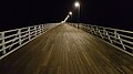
.jpg) 저녁에 숀클리프 부두 | |||||||||||||||
 숀클리프 | |||||||||||||||
| 좌표 | 27°19′38″s 153°04′46§ E/27.3272°S 153.0794°E좌표: 27°19°38°S 153°04°46°E / 27.3272°S 153.0794°E/ (시외 | ||||||||||||||
| 인구. | 1,870 (2016년 인구조사)[1] | ||||||||||||||
| • 밀도 | 1,250/km2(3,230/150mi) | ||||||||||||||
| 우편 번호 | 4017 | ||||||||||||||
| 지역 | 1.5km2(0.6평방마일) | ||||||||||||||
| 시간대 | 미학(UTC+10:00) | ||||||||||||||
| 위치 | 브리즈번 GPO 21km(13마일) NNE | ||||||||||||||
| LGA | 브리즈번 시 (Deagon Ward)[2] | ||||||||||||||
| 주의 유권자 | 샌드게이트 | ||||||||||||||
| 연방 부문 | 릴리 | ||||||||||||||
| |||||||||||||||
Shorncliffe는 호주 [3]퀸즐랜드주 브리즈번시에 있는 북동부 해안 교외입니다.그것은 모레톤 베이의 일부인 브램블 베이의 해안에 있다.2016년 인구조사에서 [1]숀클리프의 인구는 1,870명이었다.교외는 역사적인 쇼른클리프 부두와 쇼른클리프와 이웃한 샌드게이트 사이의 해안선을 따라 걷는 길인 러버스 워크로 방문객들을 유혹합니다.
지리

Shorncliffe는 Brisbane의 북동쪽 교외, Moreton Bay의 일부인 Bramble Bay에 위치하고 있습니다.
Shorncliffe는 북쪽, 북동쪽, 동쪽은 브램블 베이에, 남동쪽, 남쪽, 남서쪽은 배추트리크(27°195454sS 153°0)에 접해 있다.5 µ00 ºE / 27.3316°S 153.0832°E / )[4] : 양배추트리 포인트 (27°19 † † S 153 †16 †E / 27.3286 153.0877에서 만으로 들어갑니다.유일한 육상 경계는 인근 교외인 Sandgate로 가는 것이며 Shorncliffe로 가는 모든 육상 교통은 Sandgate를 [6]경유해야 합니다.
Railway Avenue의 Shorncliffe 기차역(27°193737sS 153°0)45050eE / 27.3269°S 153.0806°E / (은 숀클리프 철도선 (원래 샌드게이트 철도선)[7]의 종점이다.
역사

원주민들은 이 지역을 넓은 [8]바다를 뜻하는 워라라고 불렀다.
양배추나무는 로버트 딕슨의 1842년 모레톤만 [9]조사에 등장한다.
이 마을은 영국 [10][11]켄트의 해변 마을인 샌드게이트의 이름을 따서 이 지역의 초기 측량가였던 제임스 버넷에 의해 샌드게이트라는 이름이 붙여졌다.켄트에 있는 샌드게이트는 인접한 절벽 꼭대기에 숀클리프 육군 캠프라는 군사 캠프를 가지고 있었다.버넷은 그 절벽의 유사성 때문에 켄트에 있는 캠프의 이름을 따서 숀클리프라고 명명했다.역사적으로 숀클리프는 샌드게이트(처음에는 독립된 샌드게이트 타운으로, 1925년부터 브리즈번 시 교외로) 내의 동네로 간주되었다.1975년 8월 11일, 숀클리프는 [12]브리즈번 시 내에서 독립된 교외가 되었다.
최초의 숀클리프 부두는 1879년에 지어졌다.브리즈번에서 샌드게이트로 오는 페리를 끌어들여 숀클리프에 승객을 내리기 위해 현지 호텔주인 윌리엄 디곤에 의해 지어졌다.그것은 1883년부터 1884년까지 지어진 더 긴 부두로 대체되었고, 이것은 [8]썰물 때 도킹하기 쉽도록 더욱 확장되었다.비록 Shorncliffe로 가는 마지막 페리가 1928년에 있었지만,[13] 그것은 여전히 행락객들에게 인기가 있었다.

1879년 12월,[14][15] 존 캐머런에 의해 샌드게이트 마을의 할당물들이 경매에 부쳐졌다.경매 광고를 하는 지도에는 금요일, 윤다, 케이트 거리에 접해 있는 할당량이 나와 있는데, 지금은 숀클리프에 있습니다.경매 광고를 하는 지도에 따르면 이용 가능한 토지는 8, 9, 10번 구역의 1~14번 구역과 7번 구역, 3번 구역인 샌드게이트 [16]타운의 일부라고 나와 있다.
영국교회는 윤다 거리 모퉁이 신호열(27°19′24sS 153°0)에 지어졌다45050eE / 27.3234°S 153.0806°E / (성 니콜라)), 당시 개발도시의 [17]중심.1880년 12월 12일 일요일 매튜 [18]헤일 주교에 의해 개장되어 헌정되었다.가로 35피트, 세로 20피트(10.7, 세로 6.1m)의 목재 교회로 150명을 수용할 수 있었다.건축가 FDG 스탠리가 설계하고 시공사인 Woodward와 Brisbane의 [19][20]Betts가 시공했습니다.1886년 9월, 그것은 바닷가 [21]마을에서 흔한 관습인 선원과 뱃사람들의 수호성인인 성 니콜라에게 바칠 것이라고 발표되었습니다.1887년에 그것은 블록의 건물의 방향을 바꾸는 것을 수반하는 증축되었고 그래서 챈슬은 원래의 동쪽이 아닌 남쪽으로 향했습니다.1930년에 지하도는 벽돌로 둘러싸여 교회 벽을 형성했다.그 [22]교회는 1988년에 폐교되었다.퀸즐랜드 정부는 이 교회를 매입해 숀클리프 주립학교에 편입시켰지만 이후 광범위한 흰개미 피해로 철거했다.스테인드글라스 창문은 보존되어 지금은 샌드게이트에 [23]있는 성 마거릿 성공회에 있다.
Shorncliffe 유아학교는 1919년 1월 28일 경찰서 옆 오래된 법원 주택에 개교했다.8세까지의 어린이를 대상으로 하고 있습니다.1928년 숀클리프 주립학교로 개교하여 완전한 초등학교 서비스를 [24][25]제공하였다.
샌드게이트 골프 클럽은 1922년 11월 25일 9홀 코스의 공식 개장으로 시작되었으며, 샌드게이트 시의회로부터 골프 코스가 지속적인 [26][27][28]이익을 가져다 줄 것이라고 믿었기 때문에 명목상의 임대료를 받고 21년간 이 부지를 임대하였다.
세인트 패트릭 대학은 1952년 [24]1월 21일에 개교했다.
1990년 6월 호주의 연합교회는 분달, 브라이튼, 샌드게이트, 숀클리프의 신도들을 합병하기로 결정했다.디곤에 있는 그들의 새로운 샌드게이트 연합 교회는 1994년 [29]11월 20일 일요일에 문을 열었다.
2011년 인구조사에서 숀클리프 인구는 1,914명으로 여성 49.3%, 남성 50.7%였다.숀클리프 인구의 중앙 연령은 41세로 호주 인구의 중앙 연령을 4세 웃돌았다.숀클리프에 사는 사람들의 78%가 호주에서 태어났고, 그 다음으로 흔한 출생 국가는 영국 5.6%, 뉴질랜드 5%, 스코틀랜드 0.8%, 미국 0.7%, 아일랜드 0.7%였다.92.4%의 사람들이 집에서 영어만 사용했고 다음으로 흔한 언어는 독일어 0.8%, 프랑스어 0.5%, 일본어 0.4%, 네덜란드어 0.3%, 세르비아어 [citation needed]0.3%였다.
2012년 3월, Shorncliffe 부두는 해양 굴착공에 의한 피해가 발견되고 엔지니어링 보고서에 의해 [13][30]부두를 구할 수 없다는 것이 밝혀짐에 따라 공공 안전을 위해 폐쇄되었다.브리즈번 시의회는 그것을 철거하고 오래된 부두와 거의 동일하게 설계된 새 부두로 교체했다.새 부두는 2016년 [31][32]3월 25일 개장했다.
2016년 인구조사에서 [1]숀클리프의 인구는 1,870명이었다.
유산 목록
Shorncliffe에는 다음과 같은 많은 유산 목록이 있습니다.
- 8 올패스 퍼레이드:머스그레이브 하우스
- 74 올패스 퍼레이드:캐버샴 왕가
- 17 금요일 거리:코티지
- 20 금요일 거리:숀클리프 주립 학교
- 19 Jetty Street: 전 Baxter's Oister Saloon
- 팜 애비뉴 30번지:하우스
- 16 파크 퍼레이드:숀클리프 로지
- 22 파크 퍼레이드:하우스
- 34 파크 퍼레이드:해딩턴 왕가
- 60 파크 퍼레이드:세인트패트릭스 칼리지
- 65 파크 퍼레이드:무라파크
- 피어 애비뉴 65번지:시뷰 호텔
- 2 철도 퍼레이드:Shorncliffe 기차역 및 오버브릿지
- 숀클리프 퍼레이드 154 & 스완 스트리트 71 : 솔트우드
- 선데이 스트리트 58번지'켈소'
- 11 Swan Street:하우스 "아르도비"
- 20 워프 스트리트: 구 드류 레지던스
- 92 윤다 거리:홀랜드 하우스
교육
Shorncliff State School은 Yundah Street(27°19 (2519S 153°045151eE3237° 153.0809E/-3237 153.( School)[54][55]에 있는 공립 초등학교입니다.2018년, 이 학교에는 345명의 학생이 등록되어 있으며, 29명의 교사(정규직 23명)와 12명의 비교직 직원(정규직 [56]8명)이 있다.
세인트 패트릭스 칼리지(St Patrick's College)는 60 파크 퍼레이드(27°192424sS 153°0)에 있는 가톨릭 초중등(5~12) 남학생 학교입니다.5 †E / 27.3234°S 153.0834°E / 패트릭)[54][57]2018년, 이 학교의 재학생 수는 1,325명, 교사 97명(95명, 비교직원 70명(정규직 62명)[56]이었다.
Shorncliffe에는 공립 중학교가 없다.가장 가까운 공립 중등학교는 서쪽으로 [6]디곤에 있는 Sandgate District State High School입니다.
시설.

샌드게이트 골프장은 올패스 [58]퍼레이드에 있습니다.
퀸즐랜드 컨트리 부녀회 샌드게이트 지부는 95 올패스 [59]퍼레이드에 있는 자원봉사 해양 구조 센터에서 만난다.
명소

Shorncliffe는 해안선, 호주에서 가장 긴 레크리에이션용 교각 중 하나인 Shorncliffe 부두, Shorncliffe와 인근 Sandgate 사이의 해안선을 따라 걷는 길인 Lovers Walk, 개들이 떨어져 있는 Moora Park와 Beach로 유명한 브리즈번 여행지이다.
이벤트
때때로 Shorncliffe는 "Blue Water Festival"을 포함한 다양한 축제를 개최하는데, 이 축제는 "Backbury Tree Creek"의 개막부터 브리즈번과 글래드스톤 요트 경주가 시작됩니다.
갤러리
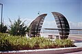
숀클리프

숀클리프
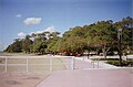
숀클리프

숀클리프의 중심가
뉴숀클리프 부두


레퍼런스
- ^ a b c Australian Bureau of Statistics (27 June 2017). "Shorncliffe (SSC)". 2016 Census QuickStats. Retrieved 20 October 2018.
- ^ "Deagon Ward". Brisbane City Council. Brisbane City Council. Archived from the original on 9 March 2017. Retrieved 12 March 2017.
- ^ "Shorncliffe – suburb in City of Brisbane (entry 41704)". Queensland Place Names. Queensland Government. Retrieved 7 July 2020.
- ^ "Cabbage Tree Creek – watercourse in City of Brisbane (entry 5610)". Queensland Place Names. Queensland Government. Retrieved 7 July 2020.
- ^ "Cabbage Tree Head – cape in City of Brisbane (entry 5631)". Queensland Place Names. Queensland Government. Retrieved 7 July 2020.
- ^ a b "Queensland Globe". State of Queensland. Retrieved 20 July 2020.
- ^ "Shorncliffe – railway station in the City of Brisbane (entry 30772)". Queensland Place Names. Queensland Government. Retrieved 20 July 2020.
- ^ a b Gregory, Helen; Dianne Mclay (2010). Building Brisbane's History: Structure, Sculptures, Stories and Secrets. Warriewood, New South Wales: Woodslane Press. p. 150. ISBN 9781921606199.
- ^ Dixon, Robert (1842). "Robert Dixon's 1842 Survey of Moreton Bay". Queensland Government. Archived from the original on 20 July 2020. Retrieved 20 July 2020.
- ^ "Sandgate – suburb in City of Brisbane (entry 41703)". Queensland Place Names. Queensland Government. Retrieved 26 January 2020.
- ^ Gregory, Helen; Dianne Mclay (2010). Building Brisbane's History: Structure, Sculptures, Stories and Secrets. Warriewood, New South Wales: Woodslane Press. ISBN 9781921606199.
- ^ "Shorncliffe – suburb in the City of Brisbane (entry 41704)". Queensland Place Names. Queensland Government. Retrieved 17 July 2020.
- ^ a b Daryl Passmore (22 April 2012). "Shorncliffe Pier protest gains speed with pledge from Lord Mayor Graham Quirk". The Sunday Mail. News Queensland. Archived from the original on 23 May 2022. Retrieved 4 June 2012.
- ^ "Classified Advertising". The Brisbane Courier. Vol. XXXIV, no. 3, 901. Queensland, Australia. 18 November 1879. p. 4. Retrieved 29 October 2019 – via National Library of Australia.
- ^ "ABSTRACT OF SALES BY AUCTION THIS DAY". The Brisbane Courier. Vol. XXXV, no. 3, 912. Queensland, Australia. 1 December 1879. p. 2. Archived from the original on 23 May 2022. Retrieved 29 October 2019 – via National Library of Australia.
- ^ "Plan of subdivisions 1 to 14, of allotments 8, 9, 10 and part of 7, Sec. 3, town of Sandgate". 1879. hdl:10462/deriv/459792.
{{cite journal}}:Cite 저널 요구 사항journal=(도움말) - ^ "Town of Sandgate". Queensland Government (Map). 1976. Archived from the original on 29 July 2020. Retrieved 29 July 2020.
- ^ "The Brisbane Courier". The Brisbane Courier. Vol. XXXV, no. 4, 231. Queensland, Australia. 11 December 1880. p. 4. Archived from the original on 28 September 2020. Retrieved 29 July 2020 – via National Library of Australia.
- ^ "CHURCH OF ENGLAND SANDGATE". The Telegraph. No. 2, 523. Queensland, Australia. 13 December 1880. p. 2. Archived from the original on 28 September 2020. Retrieved 29 July 2020 – via National Library of Australia.
- ^ "St Margaret's Anglican Church". Brisbane Heritage Register. Brisbane City Council. Retrieved 29 July 2020.
- ^ "Local Items". Moreton Mail. Vol. 1, no. 38. Queensland, Australia. 25 September 1886. p. 5. Archived from the original on 28 September 2020. Retrieved 29 July 2020 – via National Library of Australia.
- ^ Anglican Church of Southern Queensland. "Closed Churches". Archived from the original on 3 April 2019. Retrieved 3 July 2020.
- ^ "St Nicolas Anglican Church". St Nicholas Center. Archived from the original on 29 July 2020. Retrieved 29 July 2020.
- ^ a b Queensland Family History Society (2010), Queensland schools past and present (Version 1.01 ed.), Queensland Family History Society, ISBN 978-1-921171-26-0
- ^ "History". Shorncliffe State School. 13 February 2020. Archived from the original on 20 July 2020. Retrieved 20 July 2020.
- ^ "Sandgate Golf Club". Archived from the original on 23 October 2014. Retrieved 23 October 2014.
- ^ "GOLF". The Brisbane Courier. National Library of Australia. 11 November 1922. p. 17. Archived from the original on 23 May 2022. Retrieved 23 October 2014.
- ^ "GOLF". The Brisbane Courier. National Library of Australia. 18 November 1922. p. 17. Archived from the original on 23 May 2022. Retrieved 23 October 2014.
- ^ "Sandgate Uniting Church". Churches Australia. Archived from the original on 4 August 2020. Retrieved 13 September 2021.
- ^ Bill Johnston (21 March 2012). "Report to decide Shorncliffe pier's fate". Northside Chronicle. Quest Newspapers. Archived from the original on 28 March 2012. Retrieved 4 June 2012.
- ^ "Shorncliffe Pier Renewal Project". Brisbane City Council. Archived from the original on 30 December 2014. Retrieved 30 December 2014.
- ^ Johnston, Bill (5 April 2016). "Shorncliffe Pier opens with glaring spelling error". Quest Community Newspapers. Archived from the original on 10 March 2022. Retrieved 9 April 2016.
- ^ "Musgrave House (entry 601499)". Queensland Heritage Register. Queensland Heritage Council. Retrieved 6 July 2013.
- ^ "Musgrave House". Brisbane Heritage Register. Brisbane City Council. Retrieved 20 July 2020.
- ^ "Caversham". Brisbane Heritage Register. Brisbane City Council. Retrieved 20 July 2020.
- ^ "17 Friday Street, Shorncliffe". Brisbane Heritage Register. Brisbane City Council. Retrieved 20 July 2020.
- ^ "Shorncliffe State School". Brisbane Heritage Register. Brisbane City Council. Retrieved 20 July 2020.
- ^ "Baxter's Oyster Saloon (former)". Brisbane Heritage Register. Brisbane City Council. Retrieved 20 July 2020.
- ^ "30 Palm Avenue, Shorncliffe". Brisbane Heritage Register. Brisbane City Council. Retrieved 20 July 2020.
- ^ "Shorncliffe Lodge". Brisbane Heritage Register. Brisbane City Council. Retrieved 20 July 2020.
- ^ "22 Park Parade, Shorncliffe". Brisbane Heritage Register. Brisbane City Council. Retrieved 20 July 2020.
- ^ "Haddington". Brisbane Heritage Register. Brisbane City Council. Retrieved 20 July 2020.
- ^ "St Patrick's College". Brisbane Heritage Register. Brisbane City Council. Retrieved 20 July 2020.
- ^ "Moora Park". Brisbane Heritage Register. Brisbane City Council. Retrieved 20 July 2020.
- ^ "Seaview Hotel". Brisbane Heritage Register. Brisbane City Council. Retrieved 20 July 2020.
- ^ "Shorncliffe Railway Station & Overbridge". Brisbane Heritage Register. Brisbane City Council. Retrieved 20 July 2020.
- ^ "Saltwood (entry 600291)". Queensland Heritage Register. Queensland Heritage Council. Retrieved 6 July 2013.
- ^ "Saltwood". Brisbane Heritage Register. Brisbane City Council. Retrieved 20 July 2020.
- ^ "Kelso". Brisbane Heritage Register. Brisbane City Council. Retrieved 20 July 2020.
- ^ "Ardovie". Brisbane Heritage Register. Brisbane City Council. Retrieved 20 July 2020.
- ^ "Drew Residence (former) (entry 602024)". Queensland Heritage Register. Queensland Heritage Council. Retrieved 6 July 2013.
- ^ "Drew Residence (former)". Brisbane Heritage Register. Brisbane City Council. Retrieved 20 July 2020.
- ^ "Holland House". Brisbane Heritage Register. Brisbane City Council. Retrieved 20 July 2020.
- ^ a b "State and non-state school details". Queensland Government. 9 July 2018. Archived from the original on 21 November 2018. Retrieved 21 November 2018.
- ^ "Shorncliffe State School". Archived from the original on 18 March 2020. Retrieved 21 November 2018.
- ^ a b "ACARA School Profile 2018". Australian Curriculum, Assessment and Reporting Authority. Archived from the original on 27 August 2020. Retrieved 28 January 2020.
- ^ "St Patrick's College". Archived from the original on 26 January 2019. Retrieved 21 November 2018.
- ^ "Contact Us". Sandgate Golf Club. Archived from the original on 23 October 2014. Retrieved 23 October 2014.
- ^ "Branch Locations". Queensland Country Women's Association. Archived from the original on 26 December 2018. Retrieved 26 December 2018.
외부 링크
- "Shorncliffe". Queensland Places. Centre for the Government of Queensland, University of Queensland.
- "Shorncliffe". BRISbites. Brisbane City Council. Archived from the original on 23 July 2008.
- "Shorncliffe". Our Brisbane. Brisbane City Council. Archived from the original on 7 September 2007.

