모시 강 농촌시
Rural Municipality of Mossey River모시 강 | |
|---|---|
| 모시 강 농촌시 | |
 | |
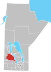
매니토바 주의 모시 강 위치 | |
| 좌표: 51°45′18″N 99°57′59″w / 51.75500°N 99.96639°W좌표: 51°45′18″N 99°57′59″W / 51.75500°N 99.96639°W/ | |
| 나라 | 캐나다 |
| 주 | 매니토바 |
| Incorporated | 1906년 5월 1일 |
| 아말감산 | 2015년[1] 1월 1일 |
| 정부 | |
| • 리브 | 론 코스티신[2] |
| 면적 | |
| • 육지 | 1,123.94km2(433.96 sq mi) |
| 인구 (2016) | |
| • 합계 | 1,145 |
| 시간대 | UTC-6(CST) |
| • 여름(DST) | UTC-5(CDT) |
| 웹사이트 | mosseyrivermunicipality |
모시 강 농촌 시 는 위니페고시스 호수의 남쪽 끝에 위치한 캐나다 매니토바 파크랜드 지역의 농촌 시이다.
시군을 흐르는 강인 모시 강의 이름을 따서 명명되었다.[3]
역사
모시 강의 농촌 자치시는 1906년 5월 1일에 통합되었다.[3] 2015년 1월 1일, 인구 1,000명 미만의 자치단체는 2015년까지 1개 이상의 인접 자치단체와 합병하도록 하는 「시립 아말감화법」의 규정에 따라 위니펙사스 마을과 합병하였다.[4][1][5] 마니토바 정부는 1997년 지방자치제를 통합하기 위한 최소 인구 요건인 1,000명을 충족시키기 위해 이 합병들을 시작했다.[6]
커뮤니티
참조
- ^ a b "The Municipal Amalgamations Act (C.C.S.M. c. M235): Village of Winnipegosis and Rural Municipality of Mossey River Amalgamation Regulation" (PDF). Government of Manitoba. Retrieved October 26, 2014.
- ^ http://www.mosseyrivermunicipality.com/p/municipal-office
- ^ a b "Manitoba Communities: Mossey River (Rural Municipality)". Manitoba Historical Society. Retrieved May 24, 2020.
- ^ https://web2.gov.mb.ca/laws/regs/current/_pdf-regs.php?reg=27/2014
- ^ "The Municipal Amalgamations Act (C.C.S.M. c. M235)". Government of Manitoba. October 2, 2014. Retrieved October 27, 2014.
- ^ "Speech from the Throne: At the Opening of the Second Session of the 40th Legislature of the Province of Manitoba". Government of Manitoba. November 19, 2012. Retrieved October 27, 2014.


