메켄보렌
Meckenbeuren메켄보렌 | |
|---|---|
 성당메리 | |
 국장 | |
보덴세크레이스 지구 내 메켄베우렌의 위치   | |
 메켄보렌  메켄보렌 | |
| 좌표:47°42′00″N 09°33′45″E/47.700°N 9.56250°E좌표: 47°42′00″N 09°33′45″E / 47.70000°N 9.56250°E/ 9 | |
| 나라 | 독일. |
| 주 | 바덴뷔르템베르크 |
| 관리 지역 | 튀빙겐 |
| 구 | 보덴세크레이스 |
| 정부 | |
| • 시장 (2017–25) | 엘리자베스 쿠겔[1] |
| 면적 | |
| • 합계 | 31.90km2(12.32제곱 mi) |
| 표고 | 435m(1,427ft) |
| 인구 (2020-12-31)[2] | |
| • 합계 | 13,621 |
| • 밀도 | 430/km2(1,100/sq mi) |
| 시간대 | UTC+01:00(CET) |
| • 여름(DST) | UTC+02:00(CEST) |
| 우편번호 | 88074 |
| 전화 코드 | 07542 |
| 차량등록 | FN |
| 웹사이트 | www.meckenbeuren.de |
메켄보렌은 남부 독일 바덴뷔르템베르크에 있는 보덴세 지구의 시이다.라벤스부르크에서 남쪽으로 10km(6마일), 콘스탄스 호수에서 프리드리히샤펜에서 북동쪽으로 8km(5마일) 떨어진 곳에 위치해 있다.
지리
위치
메켄베우렌은 프리드리히샤펜에서 북쪽으로 약 8km, 라벤스부르크에서 남쪽으로 10km 떨어진 콘스탄스 호수 근처의 하류 슈센탈 계곡에 위치해 있다.
구
The municipality of Meckenbeuren includes, in addition to the core town of Obermeckenbeuren (since 1810), the former municipalities incorporated in 1937 and today's districts of Brochenzell and Liebenau (with the hamlets of Brugg, Hegenberg, Hirschach, Knellesberg, Langentrog, Schwarzenbach, Senglingen and Weiler, the farms of Berg, Buch, Furt, Hasenwinkel, Hohenreute, Holzbauer, Hungersberg, Kratzerach, Laufenen, Lohner, Madenreute, Mühlebach, Ottmarsreute, Rebholz, Regulator, Reuter, Sandgrub, Stengele, Straß, Untertennennenmoos and the houses Habacht) as well as the village of Kehlen, which was incorporated in 1972 (with the villages Kehlen and Reute, the hamlets of Buch, Gerbertshaus, Gu첸하우스, 홀츠루트, 로크브뤼케, 샘멜레쇼펜, 사센, 쉬르텐, 슈펜위스, 시브랏쇼우스, 시글리쇼펜, 안뜰, 그로부치, 헤첼푸르트, 쉰델호프, 그리고 슈벨베르의 집들).
주요 관광지
- 라벤스버거 스필랜드 : 리베나우 지구의 25헥타르 유원지
- 브로첸첼 지구의 혹시슈로스(Humpis Castle)에 있는 혹시스뮤지엄(Humpis Museum)
갤러리
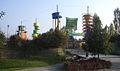
라벤스버거 스필랜드(주변 공원)

브로첸첼 지구의 혹시클로즈
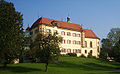
슈로스 리베나우 (리베나우 성)


쌍둥이 도시
| 위키미디어 커먼즈에는 메켄빈과 관련된 미디어가 있다. |
참조
- ^ 슈타츠안자이거의 아크투엘레 왈레르게비시스는 2021년 9월 11일에 접속했다.
- ^ "Bevölkerung nach Nationalität und Geschlecht am 31. Dezember 2020" [Population by nationality and sex as of December 31, 2020] (CSV). Statistisches Landesamt Baden-Württemberg (in German). June 2021. Retrieved 17 October 2021.


