롱포르마쿠스
Longformacus| 롱포르마쿠스 | |
|---|---|
 마을로 들어서다 | |
 롱포르마쿠스 스코틀랜드 국경 내의 위치 | |
| OS 그리드 참조 | NT693572 |
| 평의회 | |
| 부관영역 | |
| 나라 | 스코틀랜드 |
| 소버린 주 | 영국 |
| 포스트타운 | 던스 |
| 우편 번호 구 | TD11 |
| 경찰 | 스코틀랜드 |
| 불 | 스코틀랜드의 |
| 구급차 | 스코틀랜드의 |
| 영국 의회 | |
| 스코틀랜드 의회 | |

롱포르마쿠스(Scottish Gaelic: Longphort Mhacais)는 스코틀랜드의 스코틀랜드 국경 지역에 있는 베르윅셔에 있는 작은 마을이다.[1] 그것은 던스에서 북서쪽으로 약 10킬로미터(6.2 mi) 떨어진 램머무어 언덕에 있다. 염료수는 마을을 통과해 동쪽으로 흐르며 근처의 화이트사더 물과 합류한다.
근처에는 룬클라이나 주름에[2][3] 고대 요새가 세워져 있던 흔적과 마티니 스톤즈 동굴이 있다.[2][3]
가에타노 도니제티가 작사하고 월터 스콧 경의 '람머무어의 신부'를 원작으로 한 오페라 루치아 디 람머무어는 람머무어를 배경으로 하고 마을의 옛 이름인 라커마코스(Lockermacus)가 스콧의 소설에 언급되어 있다.[4]
스코틀랜드 남부를 가로지르는 장거리 노선인 서던 업랜드 웨이(Southern Upland Way)가 마을을 통과하고, 모팻에서 콕번스파스로 가는 월터 스콧 웨이 경은 롱포마쿠스를 통과한다.
어원
롱포르마쿠스는 '마카스의 진영'[5]이라는 뜻의 게일릭 롱포트 마하카이에서 유래되었다. '맥커스 땅에 있는 교회'라는 뜻의 란 포티르 마쿠스에서 유래한 것도 제안되었다.[6]
역사
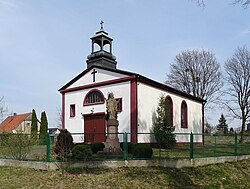
.jpg)

롱포르마쿠스 교회는 1243년 3월 11일 주교 다비드 드 버넘에 의해 헌납되었다. 1667년 합창단은 폐허가 되었고, 교회 자체는 "매우 폐허가 되었다." 그것은 1730년에 옛 기초 위에 다시 세워졌고, 1895년에 철저한 개보수가 이루어졌다. 우리 숙녀의 우물은 마을에서 동쪽으로 약 4분의 1마일 떨어진 염료수 위에 있다. 교구는 오랫동안 매딩턴에 단결되었으나, 1666년에 해체되었다. 롱포르마쿠스와 엘렘은 1712년에 통합되었고, 엘렘 교회는 사용되지 않았다.[9][10] 전직 장관이 제련했던 지역에 구리 광석이 있었지만 대규모 생산은 성공하지 못했다.[11][12]
롱포르마카스 출신
- 알렉산더 크리스티슨 FRSE[13] 교수
- 토마스 오드, 롱포르마쿠스 장관의 아들, 서커스 기수.[14]
참고 항목
근처에 크랜쇼, 애비 세인트 바탄스, 본클, 프레스턴, 스코틀랜드 국경, 화이트사더 워터, 던스 등이 있다.[15]
참조
- ^ "OS 25 inch Map 1841-1952". zoomable map with Bing transparency overlay. National Library of Scotland. Retrieved 10 October 2017.
- ^ a b Groome, Francis H. "Longformacus". Ordnance Gazetteer of Scotland. Gazetteer for Scotland. Retrieved 27 March 2018.
- ^ a b First Report and Inventory of Monuments and Constructions in the County of Berwick (PDF). HMSO. 1909. p. 43.
- ^ Scott, Walter, Sir (1800). The heart of Midlothian; The bride of Lammermoor. Boston: Dana Estes & company. p. 380. Retrieved 31 December 2019.
- ^ "Scottish Parliament - Placenames K-O" (PDF).
- ^ "Place-names of Scotland". 1892.
- ^ Riddell, Henry (1834). The new statistical account of Scotland. Vol. 2. Edinburgh and London: William Blackwood and Sons. pp. 93-98. Retrieved 30 December 2019.
- ^ Robson, James (1896). The churches and churchyards of Berwickshire. Kelso: Rutherford. pp. 171-174. Retrieved 30 December 2019.
- ^ Scott, Hew (1917). Fasti ecclesiae scoticanae; the succession of ministers in the Church of Scotland from the reformation. Vol. 2. Edinburgh: Oliver and Boyd. p. 24. Retrieved 15 April 2019.
 이 글은 공개 도메인에 있는 이 출처의 텍스트를 통합한다..
 - ^ Rutherfurd, J. and J. H. (1866). The southern counties' register and directory; containing much useful and interesting information, and very complete lists connected with the counties of Roxburgh, Berwick, and Selkirk. Kelso: J. and J.H.Ruthderfurd, etc. pp. 662–666. Retrieved 31 December 2019.
- ^ Ord, Selby (1791). The statistical account of Scotland. Vol. 1. Edinburgh: Printed and sold by William Creech. pp. 69-71. Retrieved 31 December 2019.
- ^ Francis Hindes, Groome (1895). Ordnance gazetteer of Scotland : a survey of Scottish topography, statistical, biographical and historical. Vol. 4. London: W. Mackenzie. p. 555. Retrieved 31 December 2019.
- ^ https://www.royalsoced.org.uk/cms/files/fellows/biographical_index/fells_indexp1.pdf[bare URL]
- ^ Baird, William (1898). Annals of Duddingston and Portobello. Edinburgh: Andrew Elliot. pp. 329-332. Retrieved 31 December 2019.
- ^ Slater, Isaac (1886). Slater's (later Pigot and Co's) Royal national commercial directory and topography of Scotland. Manchester: Isaac Slater. pp. 331-332. Retrieved 31 December 2019.
- ^ "Longformacus". CANMORE. Royal Commission on the Ancient and Historical Monuments of Scotland. Retrieved 11 May 2010.
외부 링크
| 위키미디어 커먼즈에는 롱포마쿠스와 관련된 미디어가 있다. |
| 일반 | |
|---|---|
| 국립도서관 | |