캐나다의 가장 긴 강 목록
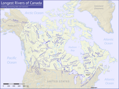
List of longest rivers of Canada캐나다에서 가장 긴 강 중에는 최소 600km(370mi)의 47개의 하천이 있다. 컬럼비아 강과 같은 일부 강의 경우 아래 표에 열거된 길이는 오로지 주줄기의 길이일 뿐이다. 매켄지 같은 다른 사람의 경우, 주목한 바와 같이 주줄기와 하나 이상의 상류 지류의 길이를 합친 것이다. 주요 줄기가 100km(62mi) 이하인 매니토바 호수와 위니펙 호수를 연결하는 짧은 연결 고리인 다우핀(Dauphin)과 같은 하천은 대상에서 제외됐다. 미시시피강과 같은 강들도 제외되는데, 이 강들의 주요 줄기는 일부 지류가 캐나다로 들어가도 들어가지 않는다.
이 목록에 있는 9개의 강이 국제 경계를 넘거나 그 강을 형성한다. 4 - 유콘, 컬럼비아, 포르쿠파인, 쿠테나이 - 캐나다에서 시작되어 미국으로 흘러들어간다. 파이브 - 밀크, 펜드 도레이유, 세인트 로렌스, 레드, 세인트 존 - 미국에서 시작되어 캐나다로 흘러간다. 이 중 밀크와 쿠테나이는 두 차례 국제 국경을 넘고, 밀크는 미국을 떠나 다시 입국하고, 쿠테나이는 캐나다에 다시 입국한다.[1] 이들 9개 강의 배수 분지는 양국으로 확장되며, 게다가 프레이저, 아시니보바인, 사우스 사스카처원, 사스카처원, 넬슨, 위니펙 등 6개 강의 배수 분지는 캐나다 내에서 통째로 흘러도 미국으로 확장된다.
소식통들은 다양한 정밀도로 수문학적 양을 보고한다. 생물학자 겸 작가인 루스 패트릭은 방류량이 많은 강들의 표를 설명하면서 방류, 배수 구역, 길이에 대한 데이터는 그녀가 상담한 작가들 사이에 매우 다양하다고 썼다. 그는 "현재와 같은 자료표를 강의 일반적인 순위를 보여주는 것으로 간주하고 수치의 사소한 차이(10~20%)를 너무 중요시하지 않는 것이 가장 현명한 방법인 것 같다"고 말했다.[2]
테이블
아래 표의 데이터에 대한 주요 출처는 캐나다 아틀라스(The Atlas of Canada)이다. 다른 출처는 언급된 바와 같다. 방전(방전)은 언급된 것을 제외하고 입안의 흐름을 말한다. 미국의 주들은 이탤릭체로 나타난다. 약어는 다음과 같다: "킬로미터"의 경우 "km", "마일"의 경우 "mi", "s"의 경우 "s", "m"의 경우 "ft"이다.
| 키 | |||||
|---|---|---|---|---|---|
참고 항목
참고 및 참조
- 메모들
- ^ 언급된 것을 제외하고, 소스 좌표는 The Atlas of Canada에 내장된 지형 지도 검색 엔진을 통해 도출되었다.[4]
- ^ 핀레이 강 머리로.[7]
- ^ 니수틀린 강의 우두머리에게. 전체 길이 3185km(1979mi)[7] 중 1149km(714mi)가 캐나다에 있다.
- ^ 캐나다에서는 약 39%인 32만3800km2(125,000mi2)와 미국에서는 약 61%인 51만5400km2(19만9000mi2)로 갈라졌다.[7]
- ^ 미네소타 세인트루이스 강 머리로.[7]
- ^ 캐나다에서는 83만9200km2(약 32만4000mi2)와 미국에서는 50만5000km2(19만5000mi2)로 갈라진다.[7]
- ^ 보우 강 머리로.[7]
- ^ 캐나다에서는 약 77%인 69만900평방킬로미터(26만6800평방미터)와 미국에서는 약 23%인 201만1400평방킬로미터(7만7800평방미터)로 갈라졌다. 두 나라의 총계는 넬슨 강에 유입되는 아시니보네, 레드, 위니펙, 서스캐처원 강에 대한 미국의 유역 미분수를 합산해 도출한 것이다.[7]
- ^ 노예강 주줄기의 길이에 평화강 길이(입구에서 핀레이강 두류까지 측정)를 더하여 도출한다.[7]
- ^ 전체의 40%인 약 801km(498mi)가 캐나다에 있다.[7]
- ^ 캐나다 102,800km(392,700mi2)와 미국 56만8,500km2(21만9,500mi2)로 갈라진다.[7]
- ^ 보우 강 머리로.[7]
- ^ 캐나다의 334,100 km2 (129,000 sq mi) (약 99.5 퍼센트)와 미국의 1,800 km2 (690 sq mi) (약 0.5 퍼센트) 사이에서 갈라진다.[7]
- ^ 핀레이 강 머리로.[7]
- ^ 처칠 호수의 머리까지.[7]
- ^ 보우 강 머리로.[7]
- ^ 캐나다의 144,300 km2 (55,700 sq mi) (약 99 퍼센트)와 미국의 1,8002 km (690 sq mi) (약 1 퍼센트)로 갈라진다.[7]
- ^ 캐나다의 경우 232,300km2(약 89,700평방mi)와 미국의 경우2 800km(310평방mi)로 갈라진다.[7]
- ^ 북아메리카의 강은 15만4880 평방 킬로미터의 분지 크기를 나열하지만 여기에는 아타바스카 호수, 피스-아타바스카 삼각주, 폰드 뒤 라크 강의 분지 및 호수로 흘러드는 다른 하천들이 포함된다.[26]
- ^ 캐나다의 16,600 km (622,600 mi2) (약 88%)와 미국의 212,400 km (82,300 mi) (약 12%)로 갈라진다.[7]
- ^ 밀크리버 유역협의회에 따르면 캐나다를 가로지르는 180km(110mi)의 강줄기가 흐른다. 이는 강 전체 길이의 약 18%에 달한다.[32]
- ^ 캐나다의 경우 2만1600km2(8300mi2)에서 미국의 경우 3만9600km2(1만5300mi2)로 갈라진다.[7]
- ^ 캣 강 머리로.[7]
- ^ Hat Island에서 1968–69년, 73년, 75–84년 데이터를 바탕으로, 입으로부터 약 200 킬로미터(120 mi) 떨어진 곳에 위치한다.[35] 캐나다 아틀라스 지형도에 포함된 측정 도구로 추정된 구강으로부터의 거리.[4]
- ^ 검은 버치 강 머리로.[7]
- ^ 1973–74년, 77–79년,[37] 입구에서 약 40km(25mi) 떨어진 석회암 래피드에서 83–84년 데이터를 근거로 한다.[38]
- ^ 머스크록스 호수의 머리까지.[7]
- ^ 255km(158mi) 또는 캐나다의 약 29%와 미국의 635km(395mi) 또는 약 71%로 나뉜다.[44]
- ^ 캐나다의 138,600 km2 (53,500 sq mi) (약 48%)와 미국의 148,900 km2 (57,500 sq mi) (약 52%)로 갈라진다.[7]
- ^ 카니아피스카우 강 머리로.[7]
- ^ 아스후아니피 강 머리로.[7]
- ^ 이것은 입보다는 입으로부터 약 100 킬로미터(62 mi) 떨어진 지점에 대한 평균 방전이다.[50]
- ^ 마조리호 출구에서 게이지로 측정하여 입구에서 약 50km(31mi) 떨어져 있다. km3/[52]yr를 m3/s로 변환하여 유도된 흐름 캐나다 아틀라스 지형도에 포함된 측정 도구로 추정된 구강으로부터의 거리.[4]
- ^ 파이어스틸 강 머리로.[7]
- ^ 캐나다의 약 78%인 10만6,500평방킬로미터(41,100평방미터)와 미국의 약 22%인 29,300평방킬로미터(11,300평방미터)로 갈라진다.[7]
- ^ 캐나다에서는 약 52퍼센트인 37,700 평방 킬로미터 (14,600 평방 미터)와 미국에서는 약 48퍼센트인 12,600 평방 킬로미터 (4,900 평방 미터)로 갈라진다.
- ^ 메기케인 강 머리로.[7]
- ^ 테미스카미 강 머리로.[7]
- ^ 아타와피스카트 호수의 우두머리에게.[7]
- ^ 1967-80년, 출처 82-84년의 데이터를 바탕으로 하구가 아닌 아타우피스카트 호수.[59]
- ^ 에나다이 호수의 머리로.[7]
- ^ 캐나다의 약 52%인 61,400 평방 킬로미터(23,700 평방 미터)와 미국의 약 48%인 56,500 평방 킬로미터(21,800 평방 미터)로 나누어져 있다.[7]
- ^ 실버 보우 크릭의 우두머리에게. 입구에서 펜드오릴 호수의 머리까지의 거리를 더하여 도출한 길이(토포 지도에 약 220km(140mi)[66]에서 클라크 포크 강과 그 두수 지류인 실버 보우 크릭(Silver Bow Creek)의 길이까지 약 480km(300mi)로 표시되어 있다.[67] 이 중 3% 정도인 22km(14mi)만 캐나다에 있다.[68]
- ^ 캐나다의 1,600 평방 킬로미터(620 평방 미)와 미국의 약 98%인 65,000 평방 킬로미터(25,000 평방 미)로 나누어져 있다.[68]
- ^ 페리본카 강 머리로.[7]
- ^ 칸와트 강 아래의 게이지로 측정되며, 앤더슨 강 어귀에서 약 150km(93mi) 떨어져 있다. km3/[52]yr를 m3/s로 변환하여 유도된 흐름 캐나다 아틀라스 지형도에 포함된 측정 도구로 추정된 구강으로부터의 거리.[4]
- ^ 오길비 강의 머리로.[7]
- ^ 캐나다의 35,000 평방 킬로미터 (14,000 평방 미) (약 63 퍼센트)와 미국의 19,700 평방 킬로미터 (7,600 평방 미) (약 37 퍼센트)로 갈라진다.[7]
- 참조
- ^ The Road Atlas. Chicago, Illinois: Rand McNally & Company. 2008. ISBN 978-0-528-93961-7.
- ^ Patrick, Ruth (1995). Rivers of the United States: Volume II: Chemical and Physical Characteristics. New York: John Wiley & Sons. p. 24. ISBN 0-471-10752-2.
- ^ a b c 다른 언급이 없는 한 캐나다 아틀라스로부터
- ^ a b c d "The Atlas of Canada, Advanced Search". Natural Resources Canada. Archived from the original on August 25, 2011. Retrieved May 18, 2011.
- ^ 달리 명시되지 않은 한 입에서 측정
- ^ "Mackenzie River, Northwest Territories". The Atlas of Canada. Natural Resources Canada. Archived from the original on October 6, 2012. Retrieved May 18, 2011.
- ^ a b c d e f g h i j k l m n o p q r s t u v w x y z aa ab ac ad ae af ag ah ai "Rivers". The Atlas of Canada. Natural Resources Canada. Archived from the original on February 2, 2007. Retrieved May 15, 2011.
- ^ "Yukon River". Geographic Names Information System. United States Geological Survey. March 31, 1981. Retrieved February 4, 2011.
- ^ 벵케와 쿠싱, 페이지 796
- ^ "Saint Lawrence River". The Atlas of Canada. Natural Resources Canada. Archived from the original on July 6, 2011. Retrieved February 3, 2011.
- ^ "Saint Louis River". Geographic Names Information System. United States Geological Survey (USGS). January 11, 1980. Retrieved May 19, 2011.
- ^ "Nelson River, Manitoba". The Atlas of Canada. Natural Resources Canada. Archived from the original on June 8, 2011. Retrieved May 16, 2011.
- ^ "Slave River, Northwest Territories". The Atlas of Canada. Natural Resources Canada. Archived from the original on October 6, 2012. Retrieved May 30, 2011.
- ^ 843 페이지 벤케와 쿠싱
- ^ "Columbia River". Geographic Names Information System. United States Geological Survey. November 28, 1980. Retrieved August 5, 2010.
- ^ 646페이지의 벤케와 쿠싱
- ^ "Saskatchewan River, Manitoba". The Atlas of Canada. Natural Resources Canada. Retrieved May 16, 2011.[영구적 데드링크]
- ^ "Peace River, Alberta". The Atlas of Canada. Natural Resources Canada. Retrieved May 16, 2011.[영구적 데드링크]
- ^ 844페이지의 벤케와 쿠싱
- ^ "Churchill River, Manitoba". The Atlas of Canada. Natural Resources Canada. Retrieved May 8, 2011.[영구적 데드링크]
- ^ "South Saskatchewan River, Saskatchewan". The Atlas of Canada. Natural Resources Canada. Retrieved May 7, 2011.[영구적 데드링크]
- ^ "Fraser River, British Columbia". The Atlas of Canada. Natural Resources Canada. Archived from the original on October 6, 2012. Retrieved May 25, 2011.
- ^ "North Saskatchewan River, Saskatchewan". The Atlas of Canada. Natural Resources Canada. Retrieved May 16, 2011.[영구적 데드링크]
- ^ "Ottawa River, Ontario". Natural Resources Canada. Retrieved May 16, 2011.[영구적 데드링크]
- ^ "Athabasca River, Alberta". The Atlas of Canada. Natural Resources Canada. Retrieved May 16, 2011.[영구적 데드링크]
- ^ a b 845페이지 벵케와 쿠싱
- ^ "Liard River, Northwest Territories". The Atlas of Canada. Natural Resources Canada. Retrieved May 12, 2011.[영구적 데드링크]
- ^ 815페이지 벤케와 쿠싱
- ^ 842 페이지 벤케와 쿠싱
- ^ "Assiniboine River, Manitoba". The Atlas of Canada. Natural Resources Canada. 누락 또는 비어 있음
url=(도움말) - ^ a b "Milk River". Geographic Names Information System. United States Geological Survey (USGS). April 4, 1980. Retrieved February 5, 2011.
- ^ "Milk River State of the Watershed Report, Part 3" (PDF). Milk River Watershed Council. 2008. Archived from the original (PDF) on September 30, 2018. Retrieved February 19, 2011.
- ^ 475페이지의 벤케와 쿠싱
- ^ "Albany River, Ontario". The Atlas of Canada. Natural Resources Canada. Archived from the original on June 8, 2011. Retrieved May 16, 2011.
- ^ SAGE: Center for Sustainability and the Global Environment (February 13, 2010). "Severn". River Discharge Database. University of Wisconsin. Archived from the original on July 23, 2011. Retrieved May 23, 2011.
- ^ "Severn River, Ontario". The Atlas of Canada. Natural Resources Canada. Archived from the original on October 10, 2012. Retrieved May 22, 2011.
- ^ SAGE: Center for Sustainability and the Global Environment (February 13, 2010). "Severn". River Discharge Database. University of Wisconsin. Archived from the original on July 23, 2011. Retrieved May 23, 2011.
- ^ Dymond, J.R.; Scott, W.B. (November 21, 1941). "Fishes of the Patricia Portion of the Kenora District, Ontario". Copeia. American Society of Ichthyologists and Herpetologists. 1941 (4): 243. doi:10.2307/1437471. JSTOR 1437471.
- ^ "Back River, Nunavut". The Atlas of Canada. Natural Resources Canada. Archived from the original on June 8, 2011. Retrieved May 4, 2011.
- ^ Marsh, James. "Back River". The Canadian Encyclopedia. Historica Dominion Institute. Archived from the original on June 8, 2011. Retrieved May 3, 2011.
- ^ "Thelon River, Nunavut". The Atlas of Canada. Natural Resources Canada. Retrieved May 5, 2011.[영구적 데드링크]
- ^ "La Grande Rivière" (in French). Gouvernement du Québec. Retrieved May 16, 2011.
- ^ "Red River". The Atlas of Canada. Natural Resources Canada. Archived from the original on July 6, 2011. Retrieved January 17, 2011.
- ^ "Red River of the North: A Water Trail Guide" (PDF). Minnesota Department of Natural Resources. 2010. Retrieved May 29, 2011.
- ^ "Red River of the North". Geographic Names Information System. United States Geological Survey (USGS). January 1, 2000. Retrieved May 29, 2011.
- ^ 벵케와 쿠싱, 페이지 896
- ^ "Rivière Koksoak" (in French). Gouvernement du Québec. Retrieved May 16, 2011.
- ^ "Churchill River, Newfoundland and Labrador". The Atlas of Canada. Natural Resources Canada. Archived from the original on August 17, 2011. Retrieved May 13, 2011.
- ^ "Coppermine River, Nunavut". The Atlas of Canada. Natural Resources Canada. Archived from the original on October 6, 2012. Retrieved May 25, 2011.
- ^ a b "Coppermine River: Overview of the Hydrology and Water Quality" (PDF). Indian and Northern Affairs Canada. July 13, 2010. pp. 1–5. Retrieved May 3, 2011.[영구적 데드링크]
- ^ "Dubawnt River, Nunavut". The Atlas of Canada. Natural Resources Canada. Archived from the original on October 6, 2012. Retrieved May 22, 2011.
- ^ a b "List of Arctic RIMS Discharge Stations". University of New Hampshire. Retrieved May 22, 2011.
- ^ "Winnipeg River, Manitoba". The Atlas of Canada. Natural Resources Canada. Retrieved May 15, 2011.[영구적 데드링크]
- ^ 벵케와 쿠싱, 페이지 898
- ^ "Kootenay River, British Columbia". The Atlas of Canada. Natural Resources Canada. Archived from the original on October 6, 2012. Retrieved May 19, 2011.
- ^ "Rivière Rupert". The Atlas of Canada. Natural Resources Canada. Archived from the original on July 1, 2012. Retrieved May 26, 2011.
- ^ "Rivière Eastmain". The Atlas of Canada. Natural Resources Canada. Archived from the original on July 7, 2012. Retrieved May 26, 2011.
- ^ "Attawapiskat River, Ontario". The Atlas of Canada. Natural Resources Canada. 누락 또는 비어 있음
url=(도움말) - ^ SAGE: Center for Sustainability and the Global Environment (February 13, 2010). "Attawapiskat". River Discharge Database. University of Wisconsin. Archived from the original on July 23, 2011. Retrieved May 23, 2011.
- ^ "Kazan River, Nunavut". The Atlas of Canada. Natural Resources Canada. 누락 또는 비어 있음
url=(도움말) - ^ "Red Deer River, Alberta". The Atlas of Canada. Natural Resources Canada. Archived from the original on October 6, 2012. Retrieved May 27, 2011.
- ^ "Grande rivière de la Baleine, Quebec". The Atlas of Canada. Natural Resources Canada. Archived from the original on July 7, 2012. Retrieved May 27, 2011.
- ^ "Porcupine River". Geographic Names Information System. United States Geological Survey. January 1, 2000. Retrieved May 21, 2011.
- ^ 802페이지의 벤케와 쿠싱
- ^ "Pend-d'Oreille River, British Columbia". The Atlas of Canada. Natural Resources Canada. Archived from the original on December 3, 2012. Retrieved June 6, 2011.
- ^ United States Geological Survey. "Hope, Idaho, quadrangle". TopoQuest. Retrieved June 6, 2011.
- ^ Merriam Webster's Geographical Dictionary (3rd ed.). Springfield, Massachusetts: Merriam-Webster, Inc. 1998. p. 258. ISBN 0-87779-546-0.
- ^ a b Swain, L.G. (August 2007). "Canada–British Columbia Water Quality Monitoring Agreement: Water Quality Assessment of Pend d'Oreille River at Waneta (1980–2006)" (PDF). British Columbia Ministry of Environment. p. 1. Archived from the original (PDF) on June 5, 2011. Retrieved June 6, 2011.
- ^ "Silver Bow Creek". Geographic Names Information System. United States Geological Survey. April 4, 1980. Retrieved June 6, 2011.
- ^ "Waneta Hydroelectric Expansion Project EAC Application" (PDF). Government of British Columbia. May 2006. p. 12. Retrieved June 8, 2011.
- ^ "Hay River, Northwest Territories". The Atlas of Canada. Natural Resources Canada. Archived from the original on October 6, 2012. Retrieved May 29, 2011.
- ^ 848페이지의 벤케와 쿠싱
- ^ "Saguenay River, Quebec". The Atlas of Canada. Natural Resources Canada. Archived from the original on October 6, 2012. Retrieved May 23, 2011.
- ^ "Anderson River, Northwest Territories". The Atlas of Canada. Natural Resources Canada. Archived from the original on October 6, 2012. Retrieved May 22, 2011.
- ^ "Peel River, Northwest Territories". The Atlas of Canada. Natural Resources Canada. Archived from the original on October 6, 2012. Retrieved May 19, 2011.
- ^ 벵케와 쿠싱, 페이지 850
- ^ "Stewart River, Yukon". The Atlas of Canada. Natural Resources Canada. Archived from the original on October 6, 2012. Retrieved May 25, 2011.
- ^ 벵케와 쿠싱, 페이지
- ^ "Horton River, Northwest Territories". The Atlas of Canada. Natural Resources Canada. Archived from the original on October 6, 2012. Retrieved May 22, 2011.
- ^ Giberson, Donna J.; Shaverdo, Helena V. (Fall 2003). "Update on the survey of aquatic insects from Keewatin and Mackenzie project: The predaceous water beetles (Coleoptera: Adephaga: Dytiscidae and Gyrinidae)". Newsletter of the Biological Survey of Canada (Terrestrial Arthropods). University of Alberta. 22 (2). Retrieved May 27, 2011.
- ^ "English River, Ontario". The Atlas of Canada. Natural Resources Canada. Archived from the original on October 6, 2012. Retrieved May 22, 2011.
- ^ "Pelly River, Yukon". The Atlas of Canada. Natural Resources Canada. April 2, 2004. Archived from the original on October 6, 2012. Retrieved May 18, 2011.
인용된 작품
- 벤크, 아서 C, 쿠싱, 콜버트 E, 리버스 오브 북아메리카 매사추세츠주 벌링턴: 엘스비에 학회지. ISBN 0-12-088253-1
