칸투르크
Kanturk칸투르크 첸 토어크 | |
|---|---|
도시 | |
 칸투르크 성 | |
| 좌표:52°10′30″n 8°54°0°W/52.17500°N 8.90000°W | |
| 나라 | 아일랜드 |
| 지방 | 먼스터 |
| 자치주 | 코크 주 |
| 인구. (2016년)[1] | 2,350 |
| 시간대 | UTC+0(WET) |
| • 여름 (DST) | UTC-1(IST(WEST)) |
Kanturk (아일랜드어: Ceann Toirc, '수아의 머리'[2][3]라는 뜻)는 아일랜드 코크주의 북서쪽에 있는 마을이다.알루아([4]Allow)강과 달로(Dallow)강이 합류하는 지점에 있으며, 이 강은 블랙워터 강으로 흘러들어갑니다.코크, 블래니, 리머릭에서 약 50km(31마일) 떨어져 있으며 N72 주요 도로 바로 북쪽에 있으며 말로에서 15km(9마일), 킬러니에서 약 40km(25마일) 떨어져 있다.칸투르크는 코크 북서달 선거구에 속해 있다.
역사
칸투르크 인근 고대 정착지의 증거는 쿨라코사네, 쿠라그, 그린네, [5]구르티나르의 주변 마을들에 있는 링포트, 성스러운 우물 및 풀라흐트 피아드 유적지를 포함한다.이 마을의 영어 이름인 칸투르크는 [2][6]멧돼지의 머리(또는 곶)를 뜻하는 아일랜드어 Ceann Toirc 또는 Ceann Tuirc에서 유래했다.
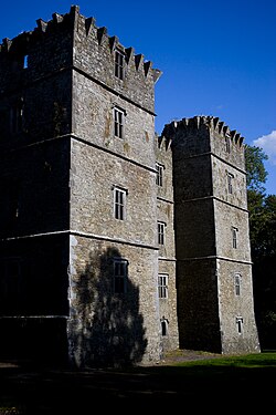
마을의 남쪽, 팔 이스트 타운랜드에는 칸투르크 성이 있습니다.지역적으로 올드 [7]코트로 알려진 이 요새화된 집은 아일랜드의 [8][9]플랜테이션 기간 동안 영국 정착민들에 대한 방어책으로 맥도날드 맥카시를 위해 1601년에 지어졌다.이 건물은 높이 4층, 길이 28m, 폭 11m의 석회암 건물로 5층 높이 29m의 4개의 탑이 있다.그 성은 결코 완전히 [10][4]완성되지 않았다.1618년 작업은 중단되었는데, 이는 현지 영국 정착민들이 건물이 너무 크고 요새화되어 그들을 [11]공격할 기지로 사용될 수 있다는 것을 우려했기 때문이라고 한다.이에 따라 영국 추밀원은 건축공사를 중단하라고 명령했다.칸투르크 성은 지난 몇 세기 동안 여러 번 주인이 바뀌어 지금은 안타이스가 소유하고 [12]있으며 국가 [10]기념물로 지정되어 있다.
2015년 현재 [13]코크 카운티 보호 구조물 기록에는 32개의 건물 또는 구조물이 등록되어 있다.여기에는 18세기 [14][15]말에서 19세기 초까지 거슬러 올라가는 마을의 다리들이 다수 포함되어 있다.칸투르크의 더 큰 종교 및 행정 건물들은 이전 시장(1810년),[16] 법원([17]1825년), 아일랜드 교회([18]1858년), 로마 가톨릭 교회(1867년)[19]를 포함한 19세기 초중반으로 거슬러 올라간다.
이코노미 및 어메니티
동네 크림 가게인 North Cork Creameries는 1928년에 설립되어 카제인 분말과 다른 우유 [20][21]제품을 생산한다.

칸투르크 도서관은 대출 시설, 신문, 참고서, 인터넷 접속, 문화 행사 [22][23]등을 제공한다.
칸투르크 타운 파크는 타운 쇼핑 센터에서 조금 떨어져 있습니다."통합석" 기념비는 공원 입구 근처에 있습니다.공원에는 참나무, 너도밤나무, 밤나무, 재나무, 어린이 놀이터, 문화 전시물, 달루아 [citation needed]강변 산책로가 있습니다.
이 마을의 학교들은 많은 국립 초등학교와 두 개의 남녀공학 중등학교를 포함한다.중등 학교인 Colaiste Revisa와 Scoil Mhuire는 [24][25]각각 500명과 270명 이상의 학생이 등록되어 있습니다.
스포츠
Kanturk GAA 클럽에는 남녀 모두 미성년자부터 중급자까지 허링 팀과 축구 팀이 있습니다.지역 경기장은 마을 바로 외곽의 킬로에 위치해 있다.Kanturk RFC는 Knocknacolan에 있는 럭비 유니온 클럽입니다.1927년에 창단된 이 클럽은 전 아일랜드 리그에 참가하고 있다.밀로드에는 18홀 골프장이 있는데, 밀링 가공이 이루어지곤 했습니다.지역 축구장은 여러 팀을 수용할 수 있는 시설을 갖추고 있다.Kanturk는 또한 아일랜드 [26]섬에 단 3개의 야외 250m 벨로드롬을 가진 사이클 클럽을 가지고 있다.
칸투르크에는 마을을 흐르는 강을 유지하는 송어 낚시 클럽이 있다.Newmarket에서 Dalua 강은 마을 중앙에 있는 Allow(프리마운트 강)로 흐릅니다.마을에서 남쪽으로 2km(1마일) 더 가면 브로젠 강이 허용강으로 흐릅니다.Allow 호는 연어 낚시로 유명한 블랙워터 강으로 합류하며, N72 Mallow에서 Killarney 로드에 있는 Leaders Bridge에서 하류 3km(2mi) 지점에 있습니다.칸투르크 송어잡이협회는 세계 파리낚시선수권대회에 [27][28]과거 회원들이 참가하는 등 여러 차례 국제무대에 모습을 드러낸 바 있다.
운송
| 연도 | Pop. | ±% |
|---|---|---|
| 1831 | 1,349 | — |
| 1841 | 4,388 | +225.3% |
| 1851 | 3,131 | −28.6% |
| 1861 | 2,285 | −27.0% |
| 1871 | 1,964 | −14.0% |
| 1881 | 1,859 | −5.3% |
| 1891 | 1,689 | −9.1% |
| 1901 | 1,583 | −6.3% |
| 1911 | 1,518 | −4.1% |
| 1926 | 1,630 | +7.4% |
| 1936 | 1,555 | −4.6% |
| 1946 | 1,577 | +1.4% |
| 1951 | 1,632 | +3.5% |
| 1956 | 2,005 | +22.9% |
| 1961 | 1,985 | −1.0% |
| 1966 | 1,938 | −2.4% |
| 1971 | 2,063 | +6.4% |
| 1981 | 1,976 | −4.2% |
| 1986 | 1,870 | −5.4% |
| 1991 | 1,777 | −5.0% |
| 1996 | 1,666 | −6.2% |
| 2002 | 1,651 | −0.9% |
| 2006 | 1,915 | +16.0% |
| 2011 | 2,263 | +18.2% |
| 2016 | 2,350 | +3.8% |
| [4][29][30][31][32][33] | ||
칸투르크는 칸투르크에서 6km(4mi) 떨어진 인근 반테어 역이 운행한다.1889년 4월 1일에 문을 열었고, 1947년 1월 27일에 승객 수송을 위해 문을 닫았고,[34] 1963년 2월 4일에 완전히 닫았다.
칸투르크를 운행하는 버스 노선은 말로까지 평일 운행이 포함되며, 그 중 하나는 코르크까지 계속 운행된다.토요일에는 말로우를 경유하여 코크로 가는 단일 버스가 운행됩니다.칸투르크는 일요일에는 버스로 운행하지 않는다.
Kanturk는 Kerry 공항에서 51km(32mi), Cork 공항에서 60km(37mi)가 조금 넘는 거리에 있습니다.
사람
이 지역의 저명한 인사는 다음과 같습니다.
- 배리 옐버튼, 제1대 에이번모어 자작(1736~1805), 정치인, 판사
- 태디 퀼(1860~1932), 역사적 갈퀴
- 패트릭 기니(1862년-1913년), 1910년부터 1913년까지 농업운동가이자 민족주의 의원
- 필립 프랜시스 존슨(1835년-1926년), 정치인, 노동운동가, 지역 호텔 경영자
- D. D. 쉬한 B.L.(1874년-1948년), 1901년부터 1918년까지 노동운동가이자 의회 의원
- 한나 쉬쉬-스케핑턴(1877년-1946년), 참의원 및 작가
- 션 P. 키팅(1903년-1976년), IRA 멤버로 뉴욕시 부시장이 되었다.
- 팻 오칼라한 박사(1905~1991년), 올림픽 금메달 2회 획득
- 파드라이그 A. 오 시오차인(1905년-1995년), 작가이자 아일랜드 언어 활동가
- 에델 퀸(1907년-1944년), 선교사 1994년 '경건'으로 선언
「 」를 참조해 주세요.
메모들
- ^ "Census 2016 Sapmap Area - Settlements - Kanturk". CSO. 2016. Archived from the original on 19 August 2018. Retrieved 18 August 2018.
- ^ a b "Ceann Toirc / Kanturk". logainm.ie. Irish Placenames Database. Retrieved 27 October 2020.
- ^ "S.I. No. 395/2012 - Placenames (County Cork) Order 2012". Irish Statute Book. Office of the Attorney General. 2012. Retrieved 24 June 2022.
- ^ a b c Lewis, Samuel (1837). "Kanturk". A Topographical Dictionary of Ireland. Dublin. Archived from the original on 30 October 2020. Retrieved 27 October 2020.
- ^ Archaeological Inventory of County Cork. Volume 4: North Cork. Dublin: Government Stationery Office. 2000.
- ^ Joyce, Patrick Weston (1869). The origin and history of Irish names of places, Volume 1. Dublin: McGlashan & Gill. p. 429.
Kanturk, in Cork, is written by the Four Masters, Ceann-tuirc, the head or hill of the boar
- ^ "The Old Court: The Story of Kanturk Castle". Archived from the original on 2 January 2017. Retrieved 28 November 2015.
- ^ "Learning Zone - Primary School Students - Looking at Places - Kanturk Castle". askaboutireland.ie. Archived from the original on 16 April 2012. Retrieved 27 May 2013.
- ^ "Historic Kanturk - An Overview". kanturk.ie. Archived from the original on 4 November 2017.
- ^ a b Heritage Castles of County Cork (PDF) (Report). Cork County Council. 2017. pp. 138–139. Archived (PDF) from the original on 30 October 2020. Retrieved 27 October 2020.
- ^ "An Abandoned Project". theirishaesthete.com. 7 December 2015. Archived from the original on 1 November 2020. Retrieved 28 October 2020.
- ^ "Our Work - Properties - Kanturk Castle, Co. Cork". antaisce.org. An Taisce. Archived from the original on 31 October 2020. Retrieved 28 October 2020.
- ^ "Section 3 (Settlements and other locations) Kanturk". Kanturk Electoral Area Local Area Plan, Second Edition, January 2015 (PDF) (Report). Cork County Council. 2015. p. 35. Retrieved 24 June 2022.
Throughout the town as a whole, there are also 32 buildings or other structures entered in the Record of Protected Structures
- ^ "Kanturk Bridge, William O'Brien Street, Main Street, Kanturk, County Cork". buildingsofireland.ie. National Inventory of Architectural Heritage. Archived from the original on 30 October 2020. Retrieved 27 October 2020.
- ^ "Brogeen Bridge, Kanturk, County Cork". buildingsofireland.ie. National Inventory of Architectural Heritage. Archived from the original on 30 October 2020. Retrieved 27 October 2020.
- ^ "Kanturk Credit Union, Strand Street, Kanturk, County Cork". buildingsofireland.ie. National Inventory of Architectural Heritage. Archived from the original on 30 October 2020. Retrieved 27 October 2020.
- ^ "Court House, Church Street, Kanturk, County Cork". buildingsofireland.ie. National Inventory of Architectural Heritage. Archived from the original on 30 October 2020. Retrieved 27 October 2020.
- ^ "Saint Peter's Church, Freemount Road, Egmont Place, Kanturk, County Cork". buildingsofireland.ie. National Inventory of Architectural Heritage. Archived from the original on 30 October 2020. Retrieved 27 October 2020.
- ^ "Church of the Immaculate Conception, Church Street, Kanturk, County Cork". buildingsofireland.ie. National Inventory of Architectural Heritage. Archived from the original on 30 October 2020. Retrieved 27 October 2020.
- ^ "It truly is dairy gold for North Cork Creameries". The Corkman. Independent News & Media. 2 November 2019. Archived from the original on 30 October 2020. Retrieved 27 October 2020.
- ^ "North Cork Creameries reveal details of merger with co-op". The Corkman. Independent News & Media. 10 February 2018. Archived from the original on 30 October 2020. Retrieved 27 October 2020.
- ^ "Kanturk Library Homepage". Archived from the original on 14 November 2016. Retrieved 13 February 2020.
- ^ "Permanent library for Kanturk after three-year delay". irishexaminer.com. Irish Examiner. 11 September 2020. Archived from the original on 30 October 2020. Retrieved 27 October 2020.
- ^ "Whole School Evaluation Report - Coláiste Treasa, Kanturk, County Cork" (PDF). education.ie. Department of Education. 8 May 2014. Archived (PDF) from the original on 30 October 2020. Retrieved 27 October 2020.
- ^ "Whole School Evaluation Report - Scoil Mhuire, Kanturk, Co Cork" (PDF). education.ie. Department of Education. 7 December 2012. Archived (PDF) from the original on 13 October 2020. Retrieved 27 October 2020.
- ^ "Our 'drome of dreams". The Corkman. Independent News & Media. 23 September 2012. Archived from the original on 30 October 2020. Retrieved 27 October 2020.
There are two other tracks in Ireland, one which is in Dublin and which is 440 metres and the other is in Belfast
- ^ "Michael hooks a bronze beauty at world c'ships in South Africa". The Corkman. Independent News & Media. 2 March 2019. Archived from the original on 30 October 2020. Retrieved 27 October 2020.
- ^ "Kanturk man to join Irish team for World C'ships". The Corkman. Independent News & Media. 16 September 2000. Archived from the original on 30 October 2020. Retrieved 27 October 2020.
- ^ "Census for post 1821 figures". Archived from the original on 9 March 2005. Retrieved 1 August 2009.
- ^ "histpop.org". Archived from the original on 7 May 2016. Retrieved 13 February 2020.
- ^ "nisranew.nisra.gov.uk". Archived from the original on 17 February 2012. Retrieved 28 January 2010.
- ^ Lee, JJ (1981). "On the accuracy of the Pre-famine Irish censuses". In Goldstrom, J. M.; Clarkson, L. A. (eds.). Irish Population, Economy, and Society: Essays in Honour of the Late K. H. Connell. Oxford, England: Clarendon Press.
- ^ Mokyr, Joel; O Grada, Cormac (November 1984). "New Developments in Irish Population History, 1700–1850". The Economic History Review. Volume. 37 (4): 473–488. doi:10.1111/j.1468-0289.1984.tb00344.x. hdl:10197/1406. Archived from the original on 4 December 2012.
- ^ "Kanturk station" (PDF). Railscot – Irish Railways. Archived (PDF) from the original on 26 September 2007. Retrieved 16 October 2007.
외부 링크
좌표: 52°10°30°N 8°54°0°W / 52.17500°N 8.90000°W /


