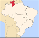
이라세마, 로라이마
Iracema, Roraima이라체마 | |
|---|---|
| 좌표: 2°10′55″n 61°2′27″w / 2.18194°N 61.04083°W좌표: 2°10′55″N 61°2′27″W / 2.18194°N 61.04083°W | |
| 나라 | 브라질 |
| 지역 | 북쪽 |
| 주 | 로라이마 |
| 정부 | |
| • 시장 | 자이로 앙드레 리베이로 수사 (PMDB) |
| 면적 | |
| • 합계 | 14,413 km2 (5,565 sq mi) |
| 인구 (2020 [1]) | |
| • 합계 | 12,296 |
| • 밀도 | 0.85/km2(2.2/sq mi) |
| 시간대 | UTC-04:00(BRT-1) |
이라세마(포르투갈어 발음: [iɾaˈsẽmɐ])는 브라질 로라이마 주의 중서부에 위치한 시이다. 인구는 12,296명(2020년), 면적은 14,413km²이다.[2] Iracema는 농업 공동체로 시작했다. 1994년에 독립된 지방자치단체가 되었다.[3] 이 마을은 BR-174 고속도로에 위치해 있으며 폭포로 유명하다.[4]
참조
- ^ IBGE 2020
- ^ "IBGE Cidades Roraima Iracema". cidades.ibge.gov.br. Retrieved 2016-06-15.
- ^ "Iracema". IBGE (in Portuguese). Retrieved 15 April 2021.
- ^ "Cachoeiras na Amazônia: deleite para os olhos e purificação para as almas". OLiberal (in Portuguese). Retrieved 15 April 2021.
| 위키미디어 커먼즈에는 이라세마(로라이마)와 관련된 미디어가 있다. |


