건너사이드
Gunnerside| 건너사이드 | |
|---|---|
 계곡 남쪽의 포병대가 | |
  건너사이드 | |
| OS 그리드 참조 | SD951982 |
| • 런던 | 210 mi (340 km) SE |
| 민교구 | |
| 구 | |
| 쉬레 현 | |
| 지역 | |
| 나라 | 잉글랜드 |
| 주권국 | 영국 |
| 포스트타운 | 달링턴 |
| 우편번호 지구 | DL11 |
| 다이얼 코드 | 01748 |
| 경찰 | 노스요크셔 주 |
| 불 | 노스요크셔 주 |
| 구급차 | 요크셔 |
| 영국 의회 | |
거너사이드는 영국 노스요크셔 리치몬드셔 지역에 있는 마을이다.B6270 도로는 무커 동쪽 2마일(3km), 그린튼 [1][2]서쪽 6마일(10km)입니다.이 마을은 요크셔 데일스 국립공원의 스왈데일 지역에 있는 스왈레강과 그 지류인 거너사이드 벡 사이에 있다.
역사
스왈레 계곡(스왈레데일)과 직각으로 북쪽으로 뻗어 있는 작은 계곡인 건너사이드 길(Ghyl)은 19세기 [5]후반까지 스왈레데일의 주요 납 광산 산업의 현장이었다.가너사이드 길 또는 가너사이드 벡이라고도 불리는 좁은 계곡을 가로지르는 벡은 로건의 시트와 워터 [6]크랙 사이에서 솟아올라 5마일(8km)을 달려 가너사이드 뉴 [7]브릿지 자리에 있는 스왈레 강으로 흘러들어갑니다.이 다리는 B6270을 마을 남쪽 스왈레 강 위로 운반한다; 19세기 동안 [8]홍수로 인해 여러 번 재건되었다.현재의 구조물은 1892년 경으로 거슬러 올라가 현재 [9]2등급이다.
Gunnerside에는 감리교 예배당, 비상근 우체국, 그리고 일하는 대장간/박물관이 있습니다.이 예배당은 1789년에 설립되었지만 [10]1866년에 재건되었다.이 구조물은 이제 등급 II [11]목록에 있습니다.마을의 사거리 북쪽에 있는 개인 건물은 중세 옥수수 제분소와 20세기 초 버스 [12]차고지였다.
마을 초등학교는 리스와 거너사이드 [13]학교의 두 곳 중 하나이다.2013년 마지막 Ofsted 검사에서 초등학교는 [14]양호 등급을 받았습니다.거너사이드 Ghyl의 발치에는 킹스 헤드 공공 주택이 있다.
지역의 고용 중심지는 시계 제작, 언덕 농사, 사냥감 관리 및 건설이며, 후자는 주로 전통적인 석조 밭 담장, 집, 축사 유지에 관한 것입니다.
주목받는 사람들

군너사이드 뉴브릿지 인근 목초지에 있는 돌 축사
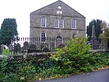
감리교회


「 」를 참조해 주세요.
레퍼런스
- ^ "Descriptive Gazetteer Entry for Gunnerside". visionofbritain.org.uk. Retrieved 17 June 2021.
- ^ "Genuki: In 1822, the following places were in the Parish of Grinton:, Yorkshire (North Riding)". www.genuki.org.uk. Retrieved 17 June 2021.
- ^ Fleming, Andrew (1999). "3;Small-scale communities and the landscape of Swaledale". In Ucko, Peter; Layton, Robert (eds.). The archaeology and anthropology of landscape : shaping your landscape (1 ed.). London: Routledge. p. 69. ISBN 9780415117678.
- ^ Ekwall, Eilert (1960). The concise Oxford dictionary of English place-names (4 ed.). Oxford: Clarendon Press. p. 399. ISBN 0-19-869103-3.
- ^ "Gunnerside Gill lead mines". www.outofoblivion.org.uk. Retrieved 17 June 2021.
- ^ 1897년, 페이지 265
- ^ "Gunnerside Gill from Source to River Swale". environment.data.gov.uk. Retrieved 17 June 2021.
- ^ 정확히 1897년, 페이지 253
- ^ Historic England. "Gunnerside New Bridge (Grade II) (1179749)". National Heritage List for England. Retrieved 17 June 2021.
- ^ "Parishes: Grinton British History Online". www.british-history.ac.uk. Retrieved 17 June 2021.
- ^ Historic England. "Methodist Chapel (Grade II) (1130790)". National Heritage List for England. Retrieved 17 June 2021.
- ^ "Gunnerside corn mill". www.outofoblivion.org.uk. Retrieved 17 June 2021.
- ^ Philby, Charlotte (19 September 2009). "The lost villages of Britain: Can our rural communities survive in the 21st century?". The Independent. Retrieved 9 October 2017.
- ^ "Gunnerside Methodist Primary School URN: 121542". reports.ofsted.gov.uk. Retrieved 17 June 2021.
- ^ Brown, Douglas. "Close, John [called Poet Close]". Oxford Dictionary of National Biography (online ed.). Oxford University Press. doi:10.1093/ref:odnb/5704. (구독 또는 영국 공공도서관 회원권 필요)
- ^ "Knut Haugland". The Telegraph. 28 December 2009. Retrieved 9 October 2017.
원천
- Speight, Harry (1897). Romantic Richmondshire: Being a complete account of the history, antiquities and scenery of the picturesque valleys of the Swale and Yore. London: E Stock. OCLC 252008733.
외부 링크
 | Wikimedia Commons에는 Gunnerside와 관련된 미디어가 있습니다. |
- 마을 건물 지도
- Gunnerside.info
- Gunnerside Gill and Swinner Gill Walk (웹 아카이브)
- 포신측 매장 기록
- 군너사이드 학교