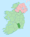
플래그마운트
Flagmount플래그마운트 안 리크 가르브 | |
|---|---|
타운랜드 | |
| 좌표:52°39′38″N 7°05′42″w/52.66057°N 7.095022°W좌표: 52°39′38″N 7°05′42″W / 52.66057°N 7.095022W/ | |
| 나라 | 아일랜드 |
| 주 | 레인스터 |
| 카운티 | 킬케니 주 |
| 부조리의 | 고우란 |
| 시민 교구 | 고우란 |
| 시간대 | UTC+0(WET) |
| • 여름(DST) | UTC-1(IST/서쪽) |
| 아일랜드 그리드 참조 | S615562 |
플래그마운트(Irish:An Leac Gharbh, '거대한 평평한 돌이나 바위'라는 뜻)는 고우란의 변리 안에 위치한 두 개의 타운랜드와 아일랜드 킬케니 카운티의 R712 국민경선도로(옛 N10 국민경선로)에 위치한 두 개의 타운랜드의 조합이다.그것은 고란 시민 교구에 위치해 있다.
총면적 452에이커(1.83km2)의 플래그마운트 남북으로 나뉜다.[1][2][3]
역사
에일리에 있는 엘리 오캐롤(Ely O'Carroll)의 O Cearbhaill(오세르빌) 부분의 최남단 영토였다.[4]
교통
플래그마운트를 통과하는 더블린과 워터포드 사이의 M9 고속도로는 2010년 9월에 개통되었다.고속도로 상공을 가로지르는 새 다리는 2010년 3월에 개통되었다.
참고 항목
메모들
- ^ "An Leac Gharbh Theas/Flagmount South". logainm.ie. Government of Ireland.
- ^ Census (1861). General Alphabetical Index to the Townlands and Towns, Parishes, and Baronies of Ireland: Based on the Census of Ireland for the Year 1851. Genealogical Publishing Com. pp. 451–452. ISBN 9780806310527.
- ^ "An Leac Gharbh Thuaidh/Flagmount North". logainm.ie. Government of Ireland.
- ^ (Cronnelly 1865, 페이지 397)
참조
- Cronnelly, Richard Francis (1865). Irish Family History; being an historical and genealogical account of the Gaedhals, from the earliest period to the present time; compiled from authentic sources. Dublin: N. H. Tallon and Company. p. 397.
추가 읽기
- Baily (1901). Baily's Magazine of Sports & Pastimes. Vinton.
- Baily (1904). Baily's Magazine of Sports & Pastimes.
- Bassett, George Henry (1884). Kilkenny city and country guide and directory. p. 61.
- Bowen, Muriel (1955). Irish hunting. Kerryman Ltd. p. 130.
- Carville, Geraldine (1979). Norman splendour: Duiske Abbey, Graignamanagh. Blackstaff Press. p. 32. ISBN 9780856401718.
- Commons, Great Britain Parliament House of (1906). Untenanted Lands (Ireland).: A Return of Untenanted Lands in Rural Districts ... A. Thom & Company, Limited. p. 134.
- Commons, Great Britain Parliament House of (1912). Parliamentary Papers, House of Commons and Command. H.M. Stationery Office.
- Inspectorate, Great Britain Mines (1903). Quarries: List of Quarries (under the Quarries Act, 1894) in the United Kingdom of Great Britain and Ireland, and the Isle of Man. H.M. Stationery Office.
- Commissioners (1849). Second Report Commissioners for Inquiring into the number and Boundaries of Poor-Law Unions and Electoral Divisions in Ireland. William Clowes and Sons. p. 45.
- Morris, Maurice O'Connor (1878). Hibernia Venatica. Chapman and Hall. pp. 228, 325.
Flagmount.
- Commissioners, Ireland Commissioners appointed for taking the Census of the Population of (1901). Census of Ireland, 1901: General Topographical Index Consisting of an Alphabetical Index to the Townlands and Towns of Ireland, and Indices to the Parishes, Baronies, Poor Law Unions ... District Electoral Divisions, Dispensary ... Districts, County Districts, County Electoral Divisions, and Parliamentary Divisions of Ireland. H.M. Stationery Office.
- Kilkenny County (1801). The presentments of the grand jury. Lent assizes, 1801 (-Spring assizes, 1824).
- County Kilkenny (1838). The presentments of the grand jury. [Continued as] At a general assizes ... the following presentments were made. Aug. 1824, Mar. 1826-July 1843. Oxford University. pp. 139, 155.
- Hunt, Kilkenny (1897). Memoir of the Kilkenny Hunt. Hodges Figgis. pp. 70, 78, 86.
- RSAI, Royal Society of Antiquaries of Ireland (1912). The Journal of the Royal Society of Antiquaries of Ireland. Royal Society of Antiquaries of Ireland. p. 4.}
- Carrigan, William (1905). The history and antiquities of the diocese of Ossory. Sealy, Bryers & Walker. p. 416.
Flagmount.
- Commons, Great Britain Parliament House of (1906). Untenanted Lands (Ireland).: A Return of Untenanted Lands in Rural Districts ... A. Thom & Company, Limited.
- General Alphabetical Index to the Townlands and Towns, Parishes, and Baronies of Ireland: Based on the Census of Ireland for the Year 1851. Genealogical Publishing Com. 1851. ISBN 9780806310527.
- Government (2003). "Placenames (Co. Kilkenny) Order 2003" (PDF). coimisineir.ie.
- "Changes to Garda Station areas in Kilkenny and Carlow (2009)" (PDF). garda.ie. 2009.
외부 링크
- "An Leac Gharbh Thuaidh/Flagmount North". logainm.ie. Government of Ireland.
- "An Leac Gharbh Theas/Flagmount South". logainm.ie. Government of Ireland.
- "Gowran Civil Parish, County Kilkenny, Tithe Applotments". www.connorsgenealogy.com.
- "Griffiths Valuation of Ireland - Gowran, County Kilkenny". www.failteromhat.com.


