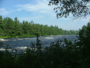
이스트 브랜치 페놉스코트 강
East Branch Penobscot River| 이스트 브랜치 페놉스코트 강 | |
|---|---|
 | |
| 위치 | |
| 나라 | 미국 |
| 물리적 특성 | |
| 출처 | |
| • 위치 | 메인 주 |
| • 고도 | 1,000피트(300m) |
| 입 | |
• 위치 | 페놉스코트 강 |
• 좌표 | 45°36′32″N 68°32′02″w / 45.60889°N 68.53389°W좌표: 45°36′32″N 68°32′02″W / 45.60889°N 68.53389°W |
• 고도 | 240피트(70m) |
| 길이 | 75마일(180km) |
| 분지형상 | |
| 지류 | |
| • 왼쪽 | 세보이스 강 |
이스트 브랜치 페놉스코트 강은 메인주 페놉스코트 강의 75.3마일(121.2km)[1]의 지류다. 피스카타키스 군과 페놉스코트 군에서 흐른다.
코스
소스로부터(46°16′01″N 69°1)2′08″W / 46.2670°N 69.2023°W) in Maine Township 7, Range 11, WELS, in Piscataquis County, the river runs 17 miles (27 km)[1] southeast through the North Maine Woods to Grand Lake Matagamon reservoir, in the northeast corner of Baxter State Park. 그랜드 레이크 댐에서 남쪽으로 48마일(77km)[1] 떨어진 페노브스코트 카운티 메드웨이의 웨스트 브랜치 페노브스코트 강과 합류한다.
마타가몬호
| 마타가몬 호 | |
|---|---|
| 좌표 | 46°10′25″n 68°50′33″w / 46.17361°N 68.84250°W |
| 최대 길이 | 8mi(13km)[2] |
| 표면적 | 4,868에이커 (1,970 ha)[3] |
| 최대 깊이 | 95피트(29m)[4] |
| 수량 | 80,878 에이커피트(99,762,000m3)[3] |
| 지표면 표고 | 653피트(199m)[5] |
그랜드 호수 마타가몬 또는 마타가몬 호는 그랜드 호수 댐이 압류한 동부 지부의 저수지다. 이 댐은 퍼스트 레이크의 출구에 건설되었고, 제2 레이크를 포함하도록 상류로 확장된 넓은 저지대 땅이 범람했다.
댐이 조성한 얕은 수생지는 송어보다는 황어, 낙어, 긴코오스흡입기에 더 적합하다.[4]
참고 항목
참조
- ^ a b c 미국 지질조사국(U.S. Geological Survey. National Hydrography Dataset 고해상도 유동선 데이터. WebCite에 보관된 2012-04-05 국가 지도, 2011년 6월 22일에 액세스
- ^ The Maine Atlas and Gazetteer (Thirteenth ed.). Freeport, Maine: DeLorme Mapping Company. 1988. pp. 51&57. ISBN 0-89933-035-5.
- ^ a b Maine Depts. of Environmental Protection and Inland Fisheries & Wildlife (2005-08-04). "Maine Lakes: Morphometry and Geographic Information". Senator George J. Mitchell Center for Environmental and Watershed Research, The University of Maine. Archived from the original on 2006-09-03. Retrieved 2008-07-31.
- ^ a b "Matagamon Lake" (PDF). Maine Department of Inland Fisheries and Game. State of Maine. Archived from the original (PDF) on 1 February 2017. Retrieved 4 May 2016.
- ^ 미국 지질조사국 지명정보시스템: 그랜드 레이크 마타고몬
- "East Branch Penobscot River". Geographic Names Information System. United States Geological Survey. 30 September 1980. Retrieved 2010-05-23.
- USGS의 메인 스트림플로 데이터
- 환경보호국의 메인 유역 데이터


