카리톤
Carrieton| 카리톤 사우스오스트레일리아 주 | |||||||||||||||
|---|---|---|---|---|---|---|---|---|---|---|---|---|---|---|---|
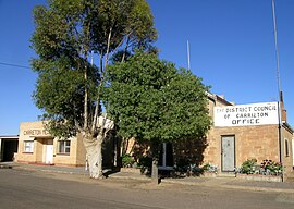
 캐리튼 기념관과 의회 사무실입니다. | |||||||||||||||
| 좌표 | 32°25′34″s 138°314444eE/32.426072°S 138.529015°E좌표: 32°25°34°S 138°31°44°E / 32.426072°S 138.529015°E / [1] | ||||||||||||||
| 인구. | 51 (2016년 [2][a]인구조사) | ||||||||||||||
| 설립된 | 1879년 4월 10일 (시) 1999년 12월 16일 (장소)[4][5] | ||||||||||||||
| 우편 번호 | 5432[6] | ||||||||||||||
| 승진 | 440 m (1,444 피트)[citation needed] | ||||||||||||||
| 시간대 | ACST(UTC+9:30) | ||||||||||||||
| • 여름 (DST) | ACST(UTC+10:30) | ||||||||||||||
| 위치 | 애들레이드 북쪽 327.8km(204마일) | ||||||||||||||
| LGA | 오로루카리에톤 구의회[1] | ||||||||||||||
| 지역 | 요크와 미드노스[1] | ||||||||||||||
| 자치주 | 달호시[1] | ||||||||||||||
| 주의 유권자 | 스튜어트[7] | ||||||||||||||
| 연방 부문 | 회색[8] | ||||||||||||||
| |||||||||||||||
| |||||||||||||||
| 각주 | 인접[1] 지역 | ||||||||||||||
캐리톤은 사우스오스트레일리아의 플린더스 산맥에 위치한 작은 마을입니다.이곳은 남쪽으로 오로루 마을과 북쪽으로 크래독 마을 사이에 위치해 있습니다.
1877년 옌야리 윔(Yanyarrie Whim)으로 처음 문을 연 이 마을은 우체국 건설과 함께 1888년 저보이스 주지사의 딸 루시 [10]캐롤라인의 이름을 따 캐리톤으로 개명했다.
철도
이 마을은 1881년 12월에 개업한 피터버러-쿠른 철도 노선에 있었으며, 1등급 역이 운행했다.큰 물품 창고와 페틀러의 오두막도 지어졌다.
1969년 사우스오스트레일리아 철도가 철도를 [citation needed]폐지하면서 여객 서비스가 중단되었다.
철도 교통량이 감소하면서 철도 운행이 점차 중단되었고, 마지막 역장은 1971년 7월 1일 철수하였다.이 철도는 1981년에 폐선되어 [11]1986년에 철거되었다.
식민지의 역사
Carrieton은 학교(1882년), 경찰서(1884년), 성 라파엘로 로마 가톨릭 교회(1889년 큰 노회), 작은 감리교(1882년), 성공회(1888년), 철도역(1885년)[12]을 1500파운드를 들여 취득했다.
최근 이력
이 도로는 R. M. Williams가 많은 연관성이 있는 지역을 인정하여 RM Williams Way로 개명되었다.카리톤은 종종 '검 그리스' 국가로 불린다.이 마을은 지역 잡화점, 호텔, 우체국, 숙박 시설을 통해 서비스되며, Orroroo Carrieton 구의회의 일부입니다.최근,[when?] 1월에 큰 폭우가 내린 후, Carrieton을 둘러싼 많은 개울들이 파괴되었다.캐리톤에서 북쪽으로 10km 떨어진 얀야리 크리크 위의 다리는 특히 역청 덩어리가 강을 따라 사라지면서 손상되었다.Yanyarrie Creek는 첫 번째 우회로가 [citation needed]몇 주 후에 또 다른 갑작스러운 홍수로 인해 다시 파괴된 후 우회로를 통해 복구되었습니다.
카리톤 로데오
캐리톤은 매년 선포일에 열리는 호주 프로 로데오 협회 행사인 캐리톤 로데오의 본고장이다.2012년 [13][failed verification]12월 28일 창립 60주년 기념대회를 열었다.
레퍼런스
- 메모들
- 인용문
- ^ a b c d e "Search results for 'Carrieton, LOCB' with the following datasets being selected - 'Suburbs and Localities', 'Postcode', 'Counties', 'Hundreds', 'Local Government Areas', 'SA Government Regions', 'Land Development Plan Zone Categories' and 'Gazetteer'". Location SA Map Viewer. Government of South Australia. Retrieved 14 February 2018.
- ^ Australian Bureau of Statistics (27 June 2017). "State Suburb of Carrieton". 2016 Census QuickStats. Retrieved 14 February 2018.
- ^ "Search results for 'Moockra, LOCB' with the following datasets being selected - 'Suburbs and Localities', 'Local Government Areas' and 'Gazetteer'". Location SA Map Viewer. Government of South Australia. Retrieved 14 February 2018.
- ^ "Untitled proclamation under the Crown Lands Consolidation Act re the Town of Carrieton" (PDF). The South Australian Government Gazette. South Australian Government. 10 April 1879. p. 1071. Retrieved 14 February 2018.
- ^ "GEOGRAPHICAL NAMES ACT 1991, Notice to Assign Boundaries and Names to Places" (PDF), The South Australian Government Gazette: 3429, 16 December 1999, retrieved 14 February 2018
- ^ 캐리턴 우편번호 호주 우편
- ^ "Electoral district of Stuart". Electoral Commission SA. Retrieved 12 February 2018.
- ^ "Federal electoral division of Grey" (PDF). Australian Electoral Commission. Retrieved 12 February 2018.
- ^ a b c "Climate statistics for HAWKER (nearest station)". Bureau of Meteorology. Retrieved 14 February 2018.
- ^ Manning, G; 1990년 Manning's Place Name of South Australia ISBN 05437687505
- ^ Evans, J 2009; Quorn Railmac 간행물 ISBN 978-1-86477-066-X로 진행
- ^ Manning, Geoff. "Y" (PDF). South Australian Place names. State Library of South Australia. p. 6. Retrieved 11 December 2017.
- ^ "Archived copy". Archived from the original on 28 July 2013. Retrieved 2013-07-08.
{{cite web}}: CS1 maint: 제목으로 아카이브된 복사(링크)


