보일 (바론)
Boyle (barony)보일 마니스티르나 부일 (이리시) | |
|---|---|
 러프 키 보기 | |
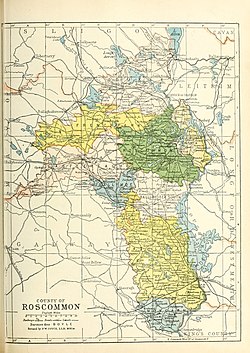
 1900년 로즈커먼 카운티의 바라니 지도; 보일은 북쪽의 분홍색이다. | |
| 소버린 주 | 아일랜드 공화국 |
| 주 | 코나흐트 |
| 카운티 | 로스커먼 |
| 면적 | |
| • 합계 | 328.46km2 (1968.82 sq mi) |
보일(Irish:Mainistir na Buille[1])은 아일랜드 공화국 로스커먼 카운티에 있는 바론이다.[2][3]
어원
보일 바론은 보일 마을의 이름을 따서 지어졌고, 그 이름은 보일 수도원의 이름을 따서 지어졌다. 그것은 보일 강의 이름을 따서 지어졌다.
지리
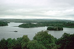
보일 바로니는 로스커먼 카운티의 북쪽 끝에 위치하고, 루프가라, 컬루 산맥, 러프 애로우에 의해 슬리고 카운티에서 분리되며, 러프 앨런과 섀넌 강에 의해 레이트림 카운티에서 분리된다.그것은 Lough Key를 포함하고 있다.[4]
역사
보일 바론은 고대 게일 왕국 마그 루아르그 안 다그다(모일루르그)에 느슨하게 대응하고 있는데, 다그다 선로의 평판이다.
1585년 코나흐트 구성에서 보일 바론은 여왕(당시 엘리자베스 1세)이나 아일랜드 교회에 속한 부분을 제외하고 맥 디아르마다의 소유로 확정되었다.[5]
정산 목록
다음은 보일의 정착지 목록이다.
참조
- ^ "Mainistir na Búille/Boyle". Logainm.ie.
- ^ "BOYLE, a corporate, market, and post-town, and a parish". www.libraryireland.com.
- ^ Weld (Isaac), Royal Dublin Society; Younger.), Isaac WELD (the (28 December 2018). "Statistical Survey of the County of Roscommon, drawn up under the direction of the Dublin Society. [With an appendix.]" – via Google Books.
- ^ Donlevy, Bryan (1 August 1792). "A map of Carrowreagh in the barony of Boyle and County of Roscommon as set by Arthur French. A scale of 40 perches to an inch. Surveyed in August 1792. By [illegible] Donleavy. Table of reference showing names of some tenants". catalogue.nli.ie.
- ^ "Perrot's Composition of the Barony of Boyle". www.irelandxo.com.


