'아라
'Ara'아라
| |
|---|---|
 65번 고속도로 남쪽 언덕에서 찍은 서쪽의 파노라마 풍경. | |
 '아라  '아라 | |
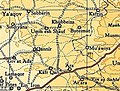
| 좌표: 32°30′20″n 35°04′41″E / 32.50556°N 35.07806°E좌표: 32°30′20″N 35°04′41″E / 32.50556°N 35.07806°E/ | |
| 격자위치 | 157/212 PAL |
| 나라 | |
| 구 | |
| 이름 의미 | "쿠르베트 아라": '아라(개인 이름)[1]의 파멸 |
아라(Hebrew: :עָָ; 아랍어: :عار)는 와디아라 계곡에 위치한 이스라엘 북부 하이파 구에 있는 마을이다. 1985년부터 '아라는 아라라 지방의회의 일원이 되었다. 65번 고속도로 북쪽, 아라라와 크파르카라 사이에 있다. 인구 4600명(2004년 기준)은 거의 전적으로 이슬람교도다.
역사
마을에서는 하얀 모자이크 포장지와 함께 매장 동굴이 출토되었다.[2]
이곳에서는 청동2B와 앞쪽 토기의 유적이 발견되었다.[3]
매장된 동굴 중 일부는 청동기 시대 중후기와 로마 시대로 거슬러 올라간다.[4] 비잔틴 램프, 유리 꽃병, 도자기 등도 발견되었다.[2][4]
이 마을에서는 우마야드 시대의 건물이 발굴되었다. 그것은 같은 시기에 만들어진 많은 도자기와 유리 항아리를 포함했다.[5]
오스만 시대
'아라는 팔레스타인의 나머지 국가들과 마찬가지로 1517년 오스만 제국에 편입되었고, 1596년 인구조사에서 마을은 라준 리와 샤라의 나히야에 있는 것으로 세무서에 나타났다. 무슬림 2가구의 인구를 가지고 있었으며 밀, 보리, 덩굴, 염소나 벌통에 25%의 고정 세율을 지불했다. 총 1,800에이커의 양봉업.[6]
1882년 PEF의 서팔레스타인 서베이서치는 "우물이 있는 눈에 띄는 마운드에 폐허의 흔적"[7]을 지적했다.
영국 위임 통치 시대
1922년 영국 정부 당국에 의해 실시된 팔레스타인 인구조사에서 '아라는 372명의 인구를 가지고 있었고, 모든[8] 이슬람교도들이 있었다.
이는 1931년 인구조사 당시 115채의 점유 주택에서 673채의 무슬림으로 늘어났다.[9]
1945년 통계에서 '아라'는 아라와 함께 집계되었는데, 무슬림 인구가 2,290명인데,[10] 그 중 800명이 '아라'에 있었다.[11]

'아라 1942년 1시 2만
'아리아 1945년 1시 25만


이스라엘
참조
참고 문헌 목록
- Abu Hamid, Amani (2010-11-17). "Kh. 'Ara (South) Final Report" (122). Hadashot Arkheologiyot – Excavations and Surveys in Israel. Cite 저널은 필요로 한다.
journal=(도움말) - Barron, J.B., ed. (1923). Palestine: Report and General Abstracts of the Census of 1922. Government of Palestine.
- Conder, C.R.; Kitchener, H.H. (1882). The Survey of Western Palestine: Memoirs of the Topography, Orography, Hydrography, and Archaeology. 2. London: Committee of the Palestine Exploration Fund.
- Dauphin, Claudine (1998). La Palestine byzantine, Peuplement et Populations. BAR International Series 726 (in French). III : Catalogue. Oxford: Archeopress. ISBN 0-860549-05-4.
- Department of Statistics (1945). Village Statistics, April, 1945. Government of Palestine.
- Hütteroth, Wolf-Dieter; Abdulfattah, Kamal (1977). Historical Geography of Palestine, Transjordan and Southern Syria in the Late 16th Century. Erlanger Geographische Arbeiten, Sonderband 5. Erlangen, Germany: Vorstand der Fränkischen Geographischen Gesellschaft. ISBN 3-920405-41-2.
- Massarwa, Abdallah (2010-07-12). "Khirbat 'Ara" (122). Hadashot Arkheologiyot – Excavations and Surveys in Israel. Cite 저널은 필요로 한다.
journal=(도움말) - Massarwa, Abdallah (2010-10-03). "Khirbat 'Ara Final Report" (122). Hadashot Arkheologiyot – Excavations and Surveys in Israel. Cite 저널은 필요로 한다.
journal=(도움말) - Mills, E., ed. (1932). Census of Palestine 1931. Population of Villages, Towns and Administrative Areas. Jerusalem: Government of Palestine.
- Palmer, E.H. (1881). The Survey of Western Palestine: Arabic and English Name Lists Collected During the Survey by Lieutenants Conder and Kitchener, R. E. Transliterated and Explained by E.H. Palmer. Committee of the Palestine Exploration Fund.
- Zertal, A. (2016). The Manasseh Hill Country Survey: From Nahal ‘Iron to Nahal Shechem. 3. Brill. ISBN 9004312307.

