사우스오스트레일리아 주
Tantanoola, South Australia| 탄타눌라 사우스오스트레일리아 주 | |||||||||||||||
|---|---|---|---|---|---|---|---|---|---|---|---|---|---|---|---|
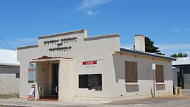
 우체국 | |||||||||||||||
| 좌표 | 37°41′51″s 140°27°20°E/37.697439°S 140.45519°E좌표: 37°41°51°S 140°27°20°E / 37.697439°S 140.455519°E / [1] | ||||||||||||||
| 인구. |
| ||||||||||||||
| 설립된 | 1879년 7월 10일 (타운) 1995년 2월 23일 (장소)[4][5] | ||||||||||||||
| 우편 번호 | 5280[6] | ||||||||||||||
| 승진 | 25 m (82 ft) (철도역)[7] | ||||||||||||||
| 시간대 | ACST(UTC+9:30) | ||||||||||||||
| • 여름 (DST) | ACDT(UTC+10:30) | ||||||||||||||
| 위치 | |||||||||||||||
| LGA | |||||||||||||||
| 지역 | 석회암 해안[8] | ||||||||||||||
| 자치주 | 회색[1] | ||||||||||||||
| 주의 유권자 | 맥킬롭[9] | ||||||||||||||
| 연방 부문 | 바커[10] | ||||||||||||||
| |||||||||||||||
| |||||||||||||||
| 각주 | 인접[1] 지역 | ||||||||||||||
탄타눌라는 사우스오스트레일리아 지방에 있는 마을이다.그 이름은 박나무/덤불나무 언덕 또는 캠프를 뜻하는 원주민 단어 tentunola에서 유래했다.탄타눌라는 1879년 7월 10일 저보이스 주지사에 의해 그의 딸 루시 캐롤라인의 이름을 따 '루시에통'으로 명명되었다.1888년 10월 4일 로빈슨 주지사에 의해 '탄타눌라'로 바뀌었다.2006년 인구조사에서 탄타눌라의 인구는 [12]255명이었다.
탄타눌라는 와트레인지 의회 지방정부 지역, 맥킬롭과 마운트감비어 사우스오스트레일리아 하원의원 선거구, 바커 하원의원 선거구에 있다.
이 초등학교는 학생보다 교원이 많은 희극적인 상황으로 인해 2020년 7월에 폐교되었다.나머지 학생들은 밀리센트와 감비에르 산의 인근 학교로 전학을 갔다.
역사
탄타눌라 마을은 애들레이드에서 남동쪽으로 425km 떨어진 힌드마르시 백도에 위치해 있으며 한때 마유라 역의 일부였다.1878년에 건설되어 1957년 좁은 궤도에서 넓은 궤도로 전환되어 1995년 4월에 화물운송을 중단한 후 2006년 7월 1일에 라즈톤 해안 철도 관광객을 위한 승객들이 탄타눌라에서 [citation needed]감비에르 산까지 128년에 걸쳐 있는 두 번째 중요한 도시였다.
역사적인 탄타눌라 역은 사우스 오스트레일리아 유산 [13]등록부에 등록되어 있습니다.
탄타눌라호랑이
탄타눌라는 19세기 후반에 이 지역을 스토킹한 것으로 추정되는 유령 고양이인 탄타눌라 호랑이로 알려져 있다.1895년 8월, 한 동물이 토마스 존 도노반에게 총을 맞았는데, 그것은 신비로운 포식자로 믿어졌다.그 동물은 고양이라기보다는 늑대에 가까운 것으로 밝혀졌다.나중에, 그것이 어떻게 남호주에 도착했는지는 많은 이론의 주제가 되었지만, 아라비아 늑대로 판명되었다.그것은 현재 보존되어 Tantanoola Hotel(구어로는 Tantanoola Tiger [14]Hotel이라고도 함)에 전시되어 있다.돌로마이트 동굴을 볼 수 있는 탄타눌라 동굴 보존 공원이 근처에 있습니다.
호주 국립도서관이 펴낸 '앵그리 펭귄: 맥스 해리스의 시집'에 수록된 '탄타눌라 호랑이'라는 제목의 시를 썼다.[15][16]
포옹
철도 노선을 따라 북서쪽으로 가는 다음 역은 Snuggy였다.아늑함은 별개의 마을로 인식되지 않지만 밀리센트로 향하는 탄타눌라의 일부입니다.이 지역에는 3개의 디젤 동력 가스 터빈이 있는 Snuggy 발전소와 킴벌리-클라크 우드칩과 제지 펄프 공장이 포함됩니다.펄프 공장은 1992년에 취역했지만 2011년에 [17]조업을 중단했다.그것은 [18]2012년 11월에 철거되었다.
「 」를 참조해 주세요.
레퍼런스
- ^ a b c d e "Search results for 'Tantanoola, LOCB' with the following datasets being selected - 'Suburbs and Localities', 'Government Towns', 'Counties', 'Local Government Areas', 'SA Government Regions', 'Land Development Plan Zone Categories' and 'Gazetteer'". Location SA Map Viewer. Government of South Australia. Retrieved 25 November 2018.
- ^ Australian Bureau of Statistics (27 June 2017). "Tantanoola (UCL)". 2016 Census QuickStats. Retrieved 21 February 2018.
- ^ Australian Bureau of Statistics (27 June 2017). "Tantanoola (SSC)". 2016 Census QuickStats. Retrieved 21 February 2018.
- ^ Morgan, William (10 July 1878). "Untitled proclamation re the Town of Lucieton" (PDF). The South Australian Government Gazette. Government of South Australia. p. 70. Retrieved 25 November 2018.
- ^ Kentish, P.M. (23 February 1995). "GEOGRAPHICAL NAMES ACT, 1991 Notice to Assign Boundaries to a Place" (PDF). The South Australian Government Gazette. South Australian Government. p. 678. Retrieved 15 May 2018.
- ^ a b c "Postcode for Tantanoola, South Australia". Postcodes Australia. Retrieved 21 February 2018.
- ^ "Search results for 'Tantanoola, LOCB' with the following datasets being selected - 'Suburbs and Localities', 'Gazetteer' and 'Railway'". Location SA Map Viewer. Government of South Australia. Retrieved 25 November 2018.
- ^ "Limestone Coast SA Government region" (PDF). The Government of South Australia. Retrieved 10 October 2014.
- ^ "District of MacKillop Background Profile". Electoral Commission SA. Retrieved 29 March 2016.
- ^ "Federal electoral division of Barker" (PDF). Australian Electoral Commission. Retrieved 28 March 2016.
- ^ a b c "Monthly climate statistics: Summary statistics Mount Gambier Aero (nearest weather station)". Commonwealth of Australia , Bureau of Meteorology. Retrieved 27 November 2018.
- ^ Australian Bureau of Statistics (25 October 2007). "Tantanoola (L) (Urban Centre/Locality)". 2006 Census QuickStats. Retrieved 29 October 2011.
- ^ "Tantanoola Railway Station & Goods Shed". South Australian Heritage Register. Department of Environment, Water and Natural Resources. Retrieved 26 August 2016.
- ^ "Tantanoola". Wattle Range Council. Archived from the original on 28 September 2007. Retrieved 31 May 2007.
- ^ "Harris Poetry". ernmalley.com. 28 December 2007. Retrieved 13 September 2008.
- ^ "Angry Penguin: Selected Poems of Max Harris". nla.gov.au. 11 September 2000. Retrieved 13 September 2008.
- ^ "Kimberly-Clark Corporation: A Proud History". Kimberly-Clark. Retrieved 16 May 2016.
- ^ Tasha Impey (5 November 2012). "Explosive end for Tantanoola pulp mill". ABC South East SA. Retrieved 16 May 2016.


