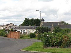
럼퍼드, 팔커크
Rumford, Falkirk| 럼퍼드 | |
|---|---|
 럼퍼드 니콜턴 로드 | |
팔커크 시의회 지역 내 위치 | |
| 인구 | 810(중간 에스트)[1] |
| OS 그리드 참조 | NS934771 |
| 시민 교구 | |
| 평의회 | |
| 부관영역 | |
| 나라 | 스코틀랜드 |
| 소버린 주 | 영국 |
| 포스트타운 | 팔키르크 |
| 우편 번호 구 | FK2 |
| 디알링 코드 | 01324 |
| 영국 의회 | |
| 스코틀랜드 의회 | |
| 웹사이트 | falkirk.gov.uk |
럼포드는 스코틀랜드의 포커크 시의회 지역에 있는 매디스톤과 브라이튼스 사이의 작은 마을이다.
이 마을은 1990년대 후반과 2000년대 초반에 큰 폭의 확장을 거치면서 1991년 인구조사 이후 인구가 기하급수적으로 늘어나 275명 내외로 기록되었다.[2]2001년과 2011년 검열에서 포커크 의회는 각각 421명과[2] 884명으로 집계했다.[3]
참고 항목
참조
- ^ "Mid-2020 Population Estimates for Settlements and Localities in Scotland". National Records of Scotland. 31 March 2022. Retrieved 31 March 2022.
- ^ a b "Insight 2001 Census, No. 3 - 2001 Census population of wards and settlements" (PDF). Falkirk Council. Retrieved 18 January 2018.
- ^ "Insight 2011 Census, No. 6 - Settlement Population and Household Estimates" (PDF). Falkirk Council. Retrieved 18 January 2018.
외부 링크
| 위키미디어 커먼즈에는 스코틀랜드 럼포드 관련 매체가 있다. |


