오하이오 애슐랜드 카운티 루글 타운쉽
Ruggles Township, Ashland County, Ohio오하이오 애슐랜드 카운티 루글 타운쉽 | |
|---|---|
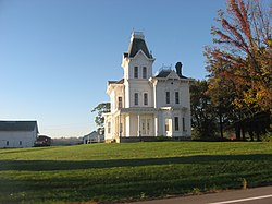
 읍내 유서 깊은 크리텐덴 농가. | |
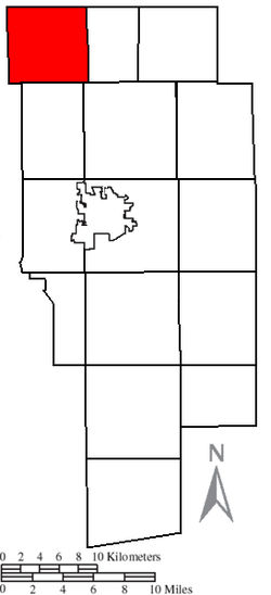
 애슐랜드 카운티의 러글 타운쉽 | |
| 좌표:41°2′23″N 82°23′2″w/41.03972°N 82.38389°W좌표: 41°2′23″N 82°23′2″W / 41.03972°N 82.389°W/ | |
| 나라 | 미국 |
| 주 | 오하이오 주 |
| 카운티 | 애슐랜드 |
| 면적 | |
| • 합계 | 26.0 sq mi(67.4km2) |
| • 육지 | 25.8 sq mi(66.9km2) |
| • 물 | 0.2 sq mi(0.5 km2) |
| 표고 | 1,086ft(331m) |
| 인구 (2010) | |
| • 합계 | 905 |
| • 밀도 | 35/sq mi(13.5/km2) |
| 시간대 | UTC-5(동부(EST)) |
| • 여름(DST) | UTC-4(EDT) |
| FIPS 코드 | 39-68966[2] |
| GNIS 피쳐 ID | 1085714[1] |
러글 타운쉽은 미국 오하이오 주 애슐랜드 카운티의 15개 타운쉽 중 하나이다.2010년 인구 조사 기준 인구는 905명이다.[3]
지리
카운티의 북서쪽 구석에 위치하며, 다음과 같은 읍과 접한다.
- 휴런 카운티 뉴런던 타운쉽 - 북부
- 로레인 카운티, 로체스터 타운쉽 - 북동쪽 코너
- 트로이 타운쉽 - 동쪽
- 오렌지 타운쉽 - 남동쪽
- 클리어 크릭 타운쉽 - 남쪽
- 리치랜드 카운티 버틀러 타운쉽 - 남서쪽
- 후론 군 그리니치 타운쉽 - 서부
- 휴런 카운티 피치빌 타운쉽 - 북서쪽 코너
루글 타운쉽에는 어떤 자치체도 없다.
이름과 역사
주 전역에 걸쳐 있는 유일한 루글 타운쉽이다.[4]
이 읍은 파이어랜드라고 알려진 지역에 포함되며, 원래는 인접한 후론 군의 일부였다.1808년 코네티컷 랜드 컴퍼니가 보유했던 측량사 알몬 루글(Almon Luleges)의 이름으로 후론 카운티 최초의 카운티 레코더다.[5][6][7]
Huron County was established by the Ohio General Assembly on February 7, 1809, and at the time comprised present-day Erie County (except a small part in the northwest), Huron County, Ruggles Township in Ashland County, Danbury Township in Ottawa County, and part of Catawba Island Township in Ottawa County[8] - in short, the entire Firelands.
루글 타운쉽은 1846년 2월 24일 휴런, 로레인, 리치랜드, 웨인 카운티 일부에서 형성되면서 애슐랜드 카운티에 추가되었다.[9]
루글 타운쉽에는 국가역사유적지표에 등재된 역사적인 농장인 크리텐덴 농가가 있다.[10]
정부
이 마을은 3명으로 구성된 이사회에 의해 운영되며, 이사회는 홀수 년부터 다음 1월 1일부터 시작되는 4년 임기의 11월에 선출된다.2명은 대통령 선거 후 연도에, 1명은 그 전 해에 선출된다.또한 선거 전 11월에 실시되는 선거 후인 4월 1일부터 4년 임기를 시작하는 선출된 읍면동 재정담당관도 있다.[11]재무관직이나 이사회에서의 결원은 나머지 신탁사들이 채운다.
참조
- ^ a b "US Board on Geographic Names". United States Geological Survey. 2007-10-25. Retrieved 2008-01-31.
- ^ "U.S. Census website". United States Census Bureau. Retrieved 2008-01-31.
- ^ "Geographic Identifiers: 2010 Demographic Profile Data (G001): Ruggles township, Ashland County, Ohio". U.S. Census Bureau, American Factfinder. Archived from the original on February 12, 2020. Retrieved July 8, 2013.
- ^ "Detailed map of Ohio" (PDF). United States Census Bureau. 2000. Retrieved 2007-02-16.
- ^ 밀라노와 밀라노 운하, 찰스 E.프로만, C.1976, 페이지 26-28.
- ^ Baughman, Abraham J. (1909). History of Huron County, Ohio: Its Progress and Development, with Biographical Sketches of Prominent Citizens of the County, Volume 1. S. J. Clarke Publishing Company. p. 166.
- ^ Williams, William W. (1879). History of the Fire Lands, Comprising Huron and Erie Counties, Ohio. Press of Leader Printing Company. pp. 501.
- ^ 오하이오 랜드스, A Short History, 오하이오 주 감사원의 간행물, c. 1994, 페이지 10.
- ^ "Ashland County". Ohio History Central. Retrieved 12 March 2014.
- ^ Baughman, Abraham J. (1909). History of Ashland County, Ohio: With Biographical Sketches of Prominent Citizens of the County. S. J. Clarke Publishing Company. pp. 457–459.
- ^ 오하이오 개정 강령의 §503.24, §505.01 및 §507.01.2009년 4월 30일에 액세스.


