파넨시에르
Pannessières파넨시에르 | |
|---|---|
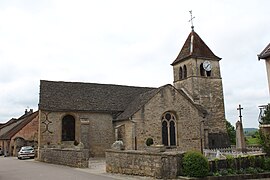
 파네시에르에 있는 교회 | |
| Coordinates: 46°41′55″N 5°35′56″E / 46.6986°N 5.5989°E | |
| 나라 | 프랑스. |
| 지역 | 부르고뉴프랑슈콩테 |
| 부서 | 쥐라 |
| 아롱디스망 | Lons-le-Saunier |
| 칸톤 | 폴리니 |
| 인터커뮤니티 | 에스페이스 코뮈네테어 론스 아글로메레이션 |
| 정부 | |
| • 시장 (2020–2026) | 모리스 모넷[1] |
| 지역 1 | 5.35 km2 (2.07 sq mi) |
| 인구. (2020년 1월)[2] | 474 |
| • 밀도 | 89/km2(230/sqmi) |
| 시간대 | UTC+01:00 (CET) |
| • 여름(DST) | UTC+02:00 (CEST) |
| INSEE/우편번호 | 39404 /39570 |
| 승진 | 280–527 m (919–1,729 ft) |
| 1 호수, 연못, 빙하가 1km2 이상(0.386 평방미터 또는 247 에이커) 및 강 하구를 제외한 프랑스 토지 등록부 데이터. | |
파넨시에르(Pannessières) 프랑스어 발음: [pansj ɛʁ]는 프랑스 동부 부르고뉴프랑슈콩테 주에 있는 코뮌입니다.
인구.
| 연도 | Pop. | ±% p.a. |
|---|---|---|
| 1968 | 433 | — |
| 1975 | 408 | −0.85% |
| 1982 | 479 | +2.32% |
| 1990 | 505 | +0.66% |
| 1999 | 465 | −0.91% |
| 2009 | 443 | −0.48% |
| 2014 | 468 | +1.10% |
| 2020 | 474 | +0.21% |
| 출처: 인시[4] | ||
참고 항목
참고문헌
- ^ "Répertoire national des élus: les maires" (in French). data.gouv.fr, Plateforme ouverte des données publiques françaises. 13 September 2022.
- ^ "Populations légales 2020". The National Institute of Statistics and Economic Studies. 29 December 2022.
- ^ INSEE commun 파일
- ^ 1968년 인구 역사학적 관점에서 볼 때, INSEE
Wikimedia Commons에는 Pannessières와 관련된 미디어가 있습니다.


