Châtel-de-Joux
Châtel-de-JouxChâtel-de-Joux | |
|---|---|
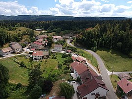
 샤텔 드 주의 항공 전경 | |
| Coordinates: 46°31′38″N 5°47′40″E / 46.5272°N 5.7944°E | |
| 나라 | 프랑스. |
| 지역 | 부르고뉴프랑슈콩테 |
| 부서 | 쥐라 |
| 아롱디스망 | 생클로드 |
| 칸톤 | 무아랑앙몽타뉴 |
| 정부 | |
| • 시장 (2022–2026) | 아나 ï스 포슬롯 |
| 지역 1 | 14.13 km2 (5.46 sq mi) |
| 인구. (2020년 1월)[2] | 52 |
| • 밀도 | 3.7/km2 (9.5/sq mi) |
| 시간대 | UTC+01:00 (CET) |
| • 여름(DST) | UTC+02:00 (CEST) |
| INSEE/우편번호 | 39118 /39130 |
| 승진 | 596–1,003 m (1,955–3,291 ft) |
| 1 호수, 연못, 빙하가 1km2 이상(0.386 평방미터 또는 247 에이커) 및 강 하구를 제외한 프랑스 토지 등록부 데이터. | |
Châtel-de-Joux ( 프랑스어 발음:ʃ ə ʒ루)는 프랑스 동부 부르고뉴프랑슈콩테주의 주라데파르트망에 위치한 코뮌입니다.
인구.
| 연도 | Pop. | ±% p.a. |
|---|---|---|
| 1968 | 72 | — |
| 1975 | 71 | −0.20% |
| 1982 | 66 | −1.04% |
| 1990 | 59 | −1.39% |
| 1999 | 48 | −2.27% |
| 2009 | 57 | +1.73% |
| 2014 | 52 | −1.82% |
| 2020 | 52 | +0.00% |
| 출처: 인시[4] | ||
참고 항목
참고문헌
- ^ "Répertoire national des élus: les maires" (in French). data.gouv.fr, Plateforme ouverte des données publiques françaises. 4 May 2022.
- ^ "Populations légales 2020". The National Institute of Statistics and Economic Studies. 29 December 2022.
- ^ INSEE commun 파일
- ^ 1968년 인구 역사학적 관점에서 볼 때, INSEE
Wikimedia Commons에는 Châtel-de-Joux와 관련된 미디어가 있습니다.


