음폰드웨
Mpondwe음폰드웨 | |
|---|---|
 음폰드웨 Mpondwe의 위치를 보여주는 우간다 지도. | |
| 좌표: 00°02'24ºN 29°43'30ºE/0.04000°N 29.72500°E | |
| 나라 | 우간다 |
| 지역 | 서부 지역 |
| 하위 영역 | 르웬츠루루아구 |
| 구 | 카세 구 |
| 승진 | 1,220m(4,000ft) |
| 인구. (2020년 추산) | |
| 총계 | 58,600[1] |
| 시간대 | UTC+3(EAT) |
역사
이 섹션은 확장이 필요합니다.추가하면 도움이 됩니다. (2023년 6월) |
2023년 6월, 음폰드웨에 있는 루비리하 중학교는 인근 콩고 민주 공화국 출신 이슬람 국가 단체와 연계된 무장 단체의 공격을 받았습니다.약 40명의 사람들, 주로 남학생들이 살해되었고 여러 명의 여학생들이 [3]납치되었습니다.
위치
이 마을은 콩고 민주 공화국 (DRC)과의 국경에 있습니다.브웨라는 음폰드웨 국경 횡단의 바로 동쪽에 있는 또 다른 정착지입니다.Mpondwe 타운 의회는 브웨라를 통합하고 있으며, 이 기사에서 "Mpondwe"는 "Mpondwe-Bwera" 메트로폴리탄 [4]지역을 통합합니다.
음폰드웨는 카세에서 남서쪽으로 약 55.5km(34마일) 떨어져 있습니다.[5]이곳은 가장 가까운 [6]대도시인 포트 포탈에서 남서쪽으로 약 131km 떨어진 곳입니다.부베라는 우간다의 수도이자 가장 큰 [7]도시인 캄팔라에서 서쪽으로 약 424km(263마일) 떨어진 곳에 위치해 있습니다.마을의 지리적 좌표는 0°02' 24.00"N, 29°43' 30.00"E(위도: 0.0400, 경도: 29.7250)[8]입니다.그 마을은 평균 해발 [9]1,220 미터 (4,000 피트)의 평균 고도에 위치해 있습니다.
개요
음폰드웨는 우간다와 콩고 민주 공화국 사이의 세 개의 가장 바쁜 국경 횡단 중 하나입니다.다른 두 곳은 네비 구역의 골리와 키소로 구역의 부나가나입니다.그 마을은 수출과 [2][10]수입의 양을 기준으로 두 나라 사이의 가장 바쁜 국경 횡단입니다.
인구.
2002년에, 전국 인구 조사는 12,050명의 Mpondwe의 인구를 추정했습니다.2010년, 우간다 통계국(UBOS)은 인구를 16,100명으로 추정했습니다.2011년, UBOS는 중간 연도의 인구를 16,[11]700명으로 추정했습니다.2014년 8월 인구 조사에 따르면 인구는 51,[12]131명입니다.
2015년, UBOS는 음폰드웨 시의 인구를 52,000명으로 추정했습니다.2020년, 인구청은 그 마을의 중간 연도의 인구를 58,600명으로 추정했습니다.이들 중 30,400명(51.9%)은 여성이었고 28,200명(48.1%)은 남성이었습니다.UBOS는 2015년과 [1]2020년 사이에 Mpondwe의 연간 인구 증가율을 연평균 2.34%로 계산했습니다.
| 연도 | Pop. | ±% |
|---|---|---|
| 2002 | 12,050 | — |
| 2010 | 16,100 | +33.6% |
| 2011 | 16,700 | +3.7% |
| 2014 | 51,131 | +206.2% |
| 2015 | 52,000 | +1.7% |
| 2020 | 58,600 | +12.7% |
| 출처:[1][11][12] | ||
원 스톱 보더 포스트
2018년 3월, 인디펜던트(우간다)는 우간다 정부가 우간다와 콩고 민주 공화국 간의 국경 간 무역을 촉진하기 위해 1,400만 달러(504억 달러)의 차관을 확보했다고 보고했습니다.우간다 정부는 우간다 산업통상협력부와 우간다 노동교통부를 통해 다른 이해관계자들과 협력하여 빌린 자금을 Mpondwe에 [2]원스톱 국경 초소(OSBP)와 국경 수출 지역(BEZ)을 건설하는 데 사용할 계획입니다.2019년 4월 17일 목요일,[13] 우간다의 요웨리 무세베니 대통령이 OSBP와 BEZ의 건설을 공식적으로 의뢰했습니다.2022년 6월 현재, OSBP와 BEZ의 완성도는 92%[14]로 추정됩니다.
관심 지점
다음 관심 지점은 마을 경계 내에 있거나 [8]마을 가장자리에 가깝습니다.
브루라 종합병원 – 우간다 보건부가 관리하는 120병상 규모의 공공병원
음폰드웨 중앙시장
음폰드웨부베라 타운 의회 사무실
Mpondwe 국경 수출 지역(개발 [15]중).
음바라-키산가니 도로는 [16]우간다와 콩고 민주 공화국 사이를 가로지릅니다.
저명인사
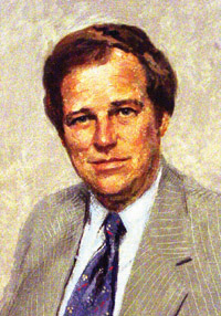
- 크리스퍼스 키용아 – 의사이자 정치인.현 주중 대사이자 우간다 내각의 전 국방부 장관.그는 이곳에서 태어났고 그 지역에 집을 가지고 있습니다.그는 또한 이 [17]선거구의 국회의원으로 선출되었습니다.
참고 항목
레퍼런스
- ^ a b c Uganda Bureau of Statistics (14 June 2021). "The population development of Mpondwe-Lhubiriha as well as related information and services" (Citypopulation.de Quoting Uganda Bureau of Statistics). Citypopulation.de. Retrieved 25 January 2021.
- ^ a b c Ssali, Godfrey (6 March 2018). "Uganda: Mpondwe Export Zone to Boost Trade Between Uganda and DR Congo". The Independent (Uganda) via AllAfrica.com. Kampala. Retrieved 8 March 2018.
- ^ "Uganda school attack: Dozens of pupils killed by militants linked to Islamic State group". BBC News. 17 June 2023.
- ^ "Parliamentary Committee On EAC Affairs Visits Mpondwe One Stop Border Post".
- ^ Google (25 January 2021). "Road Distance Between Kasese, Uganda And Mpondwe, Uganda" (Map). Google Maps. Google. Retrieved 25 January 2021.
- ^ Google (25 January 2021). "Mpondwe" (Map). Google Maps. Google. Retrieved 25 January 2021.
- ^ Google (25 January 2021). "Map Showing Kampala, Uganda And Bwera, Uganda With Distance Marker" (Map). Google Maps. Google. Retrieved 25 January 2021.
- ^ a b Google (2 July 2015). "Location of Mpondwe At Google Maps" (Map). Google Maps. Google. Retrieved 2 July 2015.
- ^ Floodmap (25 January 2021). "Elevation of Mpondwe, Uganda". Floodmap.net. Retrieved 25 January 2021.
- ^ Muwanga, David (10 August 2006). "Busia leads in border trade". New Vision. Kampala. Retrieved 19 May 2016.
- ^ a b Uganda Bureau of Statistics (2012). "Estimated Population of Mpondwe In 2002, 2010 And 2011" (PDF). Kampala: Uganda Bureau of Statistics. Archived from the original (Archived from the original on 19 January 2013) on 2014-07-07. Retrieved 25 January 2021.
- ^ a b Uganda Bureau of Statistics (14 June 2020). "The population of all Ugandan cities and towns with more than 15,000 inhabitants according to census results and latest official projections" (Citypopulation.de Quoting Uganda Bureau of Statistics). Citypopulation.de. Retrieved 25 January 2021.
- ^ a b c Felix Basiime (17 April 2019). "Museveni to open one-stop-border post in Kasese". Daily Monitor. Kampala. Retrieved 18 April 2019.
- ^ David Lumu (8 June 2022). "Mpondwe one-stop border post completion at 92% – works officials". New Vision. Kampala. Retrieved 3 August 2022.
- ^ The Independent (6 March 2018). "Mpondwe export zone to boost trade between Uganda and DR Congo". The Independent (Uganda). Kampala. Retrieved 18 April 2019.
- ^ Samuel Baya (19 February 2019). "Missing links in proposed Mombasa-Lagos highway". Business Daily Africa. Nairobi. Retrieved 25 January 2021.
- ^ UPDF-SFC (2018). "Profile of Kiyonga Chrispus Walter Barrabusa, Former Member of Parliament for Bukonjo County West, Kasese District & Former Minister of Defence". Entebbe: Uganda Special Forces Command (UPDF-SFC). Archived from the original on 18 April 2019. Retrieved 18 April 2019.
수도: 카세 | ||
| 읍·면 |  | |
| 경제. |
| |
| 운송 | ||
| 에너지 |
| |
| 주목할 만한 랜드마크 | ||
| 헬스 | ||
| 저명인사 | ||