렘스터랜드
Lemsterland렘스터랜드 렘스테를란 | |
|---|---|
구 시 | |
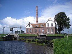
 에히텐의 양수장 | |
 프리슬랜드의 위치 | |
| 좌표:52°51°N 화씨 5°43°E/52.850°N 5.717°E좌표: 52°51′N 5°43′E / 52.850°N 5.717°E | |
| 나라 | 네덜란드 |
| 주 | 프라이스랜드 |
| 용해됨 | 2014년[1] 1월 1일 |
| 면적 | |
| • 합계 | 124.34km2(48.01 sq mi) |
| • 육지 | 75.93km2(29.32 sq mi) |
| • 물 | 48.41km2(18.69 sq mi) |
| 표고 | 0m(0ft) |
| 인구 (2013년 11월)[4] | |
| • 합계 | 13,544 |
| • 밀도 | 178/km2(460/sq mi) |
| 시간대 | UTC+1(CET) |
| • 여름(DST) | UTC+2(CEST) |
| 우편번호 | 8508, 8530–8539 |
| 지역번호 | 0514 |
렘스터랜드 (Dutch: [ˈlɛmstərrnt] ![]() (듣기);웨스트 프리지아어:렘스테를란)은 네덜란드 북부의 전 자치단체다.2014년 스카스테를란과 가아스터를라트 자치구와 합병하여 새로운 자치단체인 드 프라이스케 마르렌을 결성하였다.
(듣기);웨스트 프리지아어:렘스테를란)은 네덜란드 북부의 전 자치단체다.2014년 스카스테를란과 가아스터를라트 자치구와 합병하여 새로운 자치단체인 드 프라이스케 마르렌을 결성하였다.
인구중심
참조
- ^ "Gemeentelijke indeling op 1 januari 2014" [Municipal divisions on 1 January 2014]. cbs.nl (in Dutch). CBS. Retrieved 10 January 2014.
- ^ "Kerncijfers wijken en buurten" [Key figures for neighbourhoods]. CBS Statline (in Dutch). CBS. 2 July 2013. Retrieved 11 July 2013.
- ^ "Postcodetool for 8531ED". Actueel Hoogtebestand Nederland (in Dutch). Het Waterschapshuis. Archived from the original on 21 September 2013. Retrieved 21 September 2013.
- ^ "Bevolkingsontwikkeling; regio per maand" [Population growth; regions per month]. CBS Statline (in Dutch). CBS. 23 December 2013. Retrieved 20 January 2014.
외부 링크
 위키미디어 커먼스의 렘스터랜드 관련 매체


