엥길체크 빙하
Engilchek Glacier| 엥길체크 빙하 | |
|---|---|
 사우스잉길첵 베이스캠프 | |
| 유형 | 계곡 빙하 |
| 위치 | 중앙 톈산 산맥, 키르기스스탄, 중국 및 카자흐스탄 |
| 좌표 | 42°09′30§ N 79°56′0″e/42.15833°N 79.93333°E좌표: 42°09°30°N 79°56°0°E / 42.15833°N 79.93333°E / |
| 지역 | 17.2평방킬로미터(7평방마일) |
| 길이 | 60.5km(38마일) |

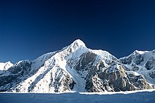
남잉길체크 빙하에서 바라본 고리키 봉
Engilcheck 빙하(키르기스어:::ilн kyrgyz en en en en en en en en en en en en en en en en is is is is is is is is is is is is is is is is is is is is is is is is is is)는 키르기스스탄 북동부 이시크쿨 지방의 중앙 티안산 산맥에 있는 빙하이다.그것의 코는 Engilchek 마을에서 동쪽으로 50km 떨어져 있다.남잉길체크 빙하는 세계에서 6번째로 긴 비극성 빙하이며 키르기스스탄에서 가장 크고 빠르게 움직이는 빙하이다.주요 빙하는 두 개의 팔을 가지고 있는데, 북부와 남부의 Engilcheck 빙하이다.후자는 더 길고 전체 길이는 60.5km(38mi)[1]입니다.17.2 평방 킬로미터(7 평방 mi)의 면적과 바닥부의 [2]얼음 두께는 약 150–200 m이다.이 빙하는 중국-카자흐-키르기스 산맥인 칸 텐그리와 피크 포베디에서 유래했으며, 빙하 상부는 [3]세 나라 모두에 떨어져 있다.빙하의 녹은 물은 중국 국경을 넘어 타림 분지로 들어가는 사리자즈의 지류인 Engilchek 강을 공급한다.이 빙하의 물은 또한 엥길체크 강 [4]계곡에 잦은 빙하호 폭발 홍수를 일으키는 계절 빙하 메르즈바허 호수에 공급된다.
레퍼런스
- ^ Häusler, Hermann. "Results from the 2009 geoscientific expedition to the Inylchek glacier, Central Tien Shan (Kyrgyzstan)" (PDF). Austrian Journal of Earth Sciences. 104 (2): 47–57. Retrieved 8 April 2020.
- ^ "Inylchek Glacier". Central Asia Adventures. Retrieved 13 May 2012.
- ^ "Engil'chek Glacier". Encyclopædia Britannica. Retrieved 13 May 2012.
- ^ Bormudoi, A; Shabunin, A; Hazarika, M; Zaginaev, V; Samarakoon, L. "Studying the outburst of the Merzbacher lake of Inylchek glacier, Kyrgyzstan with Remote Sensing and Field Data". Retrieved 20 June 2015.
{{cite journal}}:Cite 저널 요구 사항journal=(도움말)


