캐시 강 주 자연 구역
Cache River State Natural Area| 캐시 강 주 자연 구역 | |
|---|---|
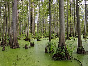
 헤론 연못의 택소듐 디스티쿰 | |
| 위치 | 미국 일리노이 주 존슨 군 |
| 가장 가까운 도시 | 일리노이 주 벨냅 |
| 좌표 | 37°21′44″N 88°57′20″w / 37.362°N 88.95556°W좌표: 37°21′44″N 88°57′20″W / 37.36222°N 88.95556°W/ |
| 면적 | 14,314 에이커(5,793 ha) |
| 확립된 | 1970 |
| 통치기구 | 일리노이 천연자원부 |
캐시 리버 주 자연 지역은 미국 일리노이 주 존슨 카운티의 캐시 강(일리노이 주)이 1만4,314에이커(5,793ha)를 중심으로 한 일리노이 주립 공원이다.
참조
- "Cache River State Natural Area". Illinois Department of Natural Resources. Archived from the original on 2007-06-07. Retrieved 2018-07-06.
- USGS. "Cache River State Natural Area, USGS Karnak (IL) Quad". TopoQuest. Retrieved 2008-07-05.


