인디애나 주 버로우스
Burrows, Indiana버로우스 | |
|---|---|
 캐롤 카운티의 인디애나 소재지 | |
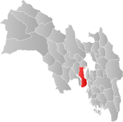
 버로우스 캐롤 카운티의 위치 | |
| 좌표:40°40′36″n 86°30′27″w/40.67667°N 86.50750°W좌표: 40°40′36″N 86°30′27″W / 40.67667°N 86.50750°W/ | |
| 나라 | 미국 |
| 주 | 인디애나 주 |
| 카운티 | 캐럴 |
| 타운쉽 | 자유 |
| 표고 | 699ft(213m) |
| 시간대 | UTC-5(EST) |
| • 여름(DST) | UTC-4(EST) |
| 우편번호 | 46916 |
| 지역 번호 | 574 |
| FIPS 코드 | 18-09460[1] |
| GNIS 피쳐 ID | 431874[2] |
버로우스는 미국 인디애나 주 캐롤 카운티 리버티 타운쉽에 있는 비법인 공동체다.인디애나 주 라파예트의 일부다.
역사
버로우스 우체국은 원래 코르누코피아라고 불렸다.[3]우체국은 1853년 버로우스(코르누코피아)에 문을 열었다.[4]
지리
버로우스는 40°40′36″N 86°30′27″W / 40.67667°N 86.50750°W/ 에 위치한다.인디애나 주 25번 도로와 노퍽 남부 철도는 모두 도시를 북동쪽으로 통과한다.
참조
- ^ "U.S. Census website". United States Census Bureau. Retrieved 2008-01-31.
- ^ "Burrows, Indiana". Geographic Names Information System. United States Geological Survey. Retrieved 2009-10-10.
- ^ Baker, Ronald L. (October 1995). From Needmore to Prosperity: Hoosier Place Names in Folklore and History. Indiana University Press. p. 83. ISBN 978-0-253-32866-3.
A post office called Cornucopia was established here...
- ^ "Carroll County". Jim Forte Postal History. Retrieved 28 August 2014.
이 인디애나주 캐롤 카운티 소재 기사는 단조롭다.위키피디아를 확장하여 도울 수 있다. |