바운더리 파이어 (2017)
Boundary Fire (2017)| 바운더리 파이어 | |
|---|---|
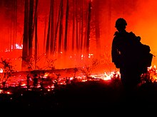
 2017년 6월 17일 경계 화재를 보는 소방관 | |
| 위치 | 미국 애리조나주 코코니노와 카이밥 국유림 |
| 좌표 | 35°25'55 ″ N 111°49'52 ″W / 35.432°N 111.831°W |
| 통계 | |
| 비용. | 940만 달러 (2022년 1,110만 달러 equival) |
| 날짜 | 2017년 6월 1일 ~ 7월 3일 |
| 불에 탄 부위 | 17,788 에이커 (71.99 km2; 27.794 sq mi) |
| 원인 | 번개 |
| 지도 | |
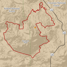
 국가기관간 화재센터에서 본 경계 화재의 총발자국 | |
바운더리 파이어는 2017년 애리조나에서 발생한 산불로 코코니노와 카이밥 국유림 17,788에이커(7,199ha)를 태웠습니다. 이 화재는 6월 1일 코코니노 국유림 내 켄드릭 피크 북동쪽의 한 지점에서 번개가 치면서 점화되었습니다. 화재는 고온, 가파른 지형, 2000년 산불로 인한 잔재물, 빠른 풍속 때문에 빠르게 번졌습니다.
바람에 연기가 지역 사회와 사회 기반 시설을 덮쳐 6월 8일부터 6월 21일까지 180번 국도가 폐쇄되었습니다. 연기는 그랜드 캐니언에서도 볼 수 있었습니다. 경계 화재는 소방 32일 만인 2017년 7월 3일에 전소되었습니다. 화재 관리 비용은 940만 달러(2022년 1,110만 달러에 해당)였습니다. 이 지역의 단풍 피해는 2018년까지 산사태 위험을 높였습니다.
배경
산불은 미국 남서부의 생태 주기에서 자연적인 부분이지만,[1]: 3–6 인간이 유발한 기후 변화로 인해 산불의 수, 파괴력, 지속 기간 및 빈도가 증가했습니다.[2] 바운더리 파이어는 2017년 애리조나주에서 429,564에이커(173,838ha)를 태운 2,321건의 산불 중 하나입니다.[3] 화재가 발생하기 약 한 달 전인 2017년 4월에 발표된 보고서에서, 애리조나 주 산림 관리인 제프 휘트니(Jeff Whitney)는 주의 북부 숲에서는 전형적인 계절을 예상했지만, 고온, 낮은 습도, 풍부한 연료 때문에 주의 남부 초원에서는 화재 가능성이 높은 계절을 예상했습니다.[4] 애리조나 주의 기온은 2017년 시즌 동안 평소보다 높았습니다.[5]: 1 7월 4일, 국립 기상국은 올해 6월이 코코니노와 카이밥 국유림 사이에 위치한 플래그스태프 시에서 기록된 다섯 번째로 더웠다고 말했습니다.[6][7] 애리조나 보건국에 따르면 플래그스태프는 6월 12일부터 27일 사이에 최고 120 °F(49 °C)의 기온을 기록했습니다.[8] 8월까지 산불은 2011년 시즌 이후 가장 많은 땅을 태웠습니다.[9]
진행
바운더리 파이어는 2017년 6월 1일 오후 2시 2분경 코코니노 국유림 내 켄드릭 피크의 북동쪽 경사면을 번개가 치면서 촉발되었습니다.[10] 불은 6월 6일까지 380 에이커 (150 ha)까지 커졌습니다. 2000년 호박 화재로 인한 어려운 지형과 남은 죽은 나무들로 인해 소방관들에게 위협을 받았기 때문에, 미국 산림청(USFS)은 바운더리 화재를 산 주변의 15,000에이커(6,100ha) 지역으로 제한하고 자연적으로 연소되도록 허용하기로 결정했습니다. 소방관들은 6월 6일, 특히 화재의 서쪽 지역의 도로를 따라 방파제를 만들기 시작했습니다.[11][12] 6월 8일, 강풍이 그 당시 화재로부터 2마일(3.2km) 떨어진 북쪽과 미국 국도 180호선(US 180)을 향해 불을 부채질했습니다.[13][14][15] 그날 밤, 소방관들이 불의 확산을 감시하는 동안 소방 관리자들은 미국 180호를 폐쇄했습니다.[14][16][17] 바운더리 파이어의 연기는 화재에서 서쪽으로 17마일(27km) 떨어진 플래그스태프(Flagstaff)와 같은 지역사회로 흘러들어갔고, 플래그스태프에서 북쪽으로 약 65마일(105km) 떨어진 그랜드캐니언(Grand Canyon)에서 볼 수 있었습니다.[16][18][19]
6월 9일까지 바운더리 파이어는 1,550 에이커(630 ha)로 커졌고, 미국 180도를 따라, 그리고 코코니노와 카이밥 국유림 내에서 불타고 있었습니다.[16] 6월 10일과 11일에 강풍에 휩싸인 그 불은 4,420 에이커 (1,790 ha)까지 불었고 261명의 소방관들에 의해 관리되고 있었습니다.[20][21][22] 6월 12일 이후, 바람이 줄어든 덕분에 USFS는 통제된 화상의 한 형태인 공중 점화 장치를 사용하여 오르막에서 불을 더 빨리 확산시켜 화재로 인한 토양 손상을 줄일 수 있었습니다.[23] 6월 14일까지, 불은 5,784 에이커 (2,341 ha)로 커졌고 공중 소방 자산을 가진 거의 500명의 소방관들에 의해 관리되고 있었습니다.[23][24] 낮은 풍속으로 인해 지상 승무원과 항공 자산은 6월 15일부터 6월 19일까지 통제된 화상으로 계속될 수 있었고,[25][26][27][28] 이는 다음 날의 고온 예측보다 앞서 있었습니다. 6월 19일까지, 그 불은 8,067 에이커 (3,265 ha)를 태웠습니다.[29] 다음날 빛의 강수, 구름덮개, 그리고 더 높은 습도를 가져왔고, 그로 인해 불은 땅으로 더 낮게 타버렸고 나뭇잎보다는 쓰레기를 소비했습니다. 소방관들은 화재 진압과 사유재산을 확보할 수 있었고, 화재 진압 비중은 18%에서 30%[30]로 늘었습니다.
6월 21일까지 미국 180호선의 가시거리는 애리조나 교통국이 제한 속도를 줄인 도로를 다시 열 수 있을 정도로 충분히 개선되었습니다.[31] 6월 22일, 소방관들은 강풍과 기온이 11,540 에이커 (4,670 헥타르)까지 불을 지폈음에도 불구하고 경계 화재를 42 %로 진압했습니다.[32] 지난 6월 23일 USFS는 화재로 폐쇄된 지역이 18,000에이커(7,300ha)까지 확대될 수 있을 것으로 [33]생각하지만 확산을 억제하는 데 진전을 이뤘다고 밝혔습니다.[34][35] 6월 25일까지 불은 17,049 에이커 (6,899 ha)까지 커졌지만 88 %가 억제되었으며 [36]온도는 88 °F (31 °C)까지 떨어졌습니다.[37] 6월 25일, 민간 드론이 불 위를 날았기 때문에 공중 소방 자산이 일시적으로 정지되었습니다.[38] 그 불은 7월 3일에 타버렸습니다.[5]: 14
후폭풍
바운더리 파이어는 32일 동안 17,788 에이커(7,199 ha)를 태웠고 진압하는 데 940만 달러(2022년 1,110만 달러 상당)의 비용이 들었습니다.[5]: 14 [10][39] 불에 탄 전체 면적 중 3%가 총 엽사 사망률을 겪었습니다. 손상되거나 파괴된 구조물은 없습니다. 대피한 민간인 4명이 화재와 관련해 부상을 입었습니다.[5]: 14–15 거의 500명의 소방관들이 경계 화재를 진압하고 진압하기 위해 일했습니다.[40]
환경에 미치는 영향
켄드릭 피크의 산책로는 북미 몬순으로 인한 폭우로 인한 산사태 가능성 때문에 2017년 9월 14일까지 다시 문을 열지 않았습니다.[41] 카이밥 국유림 감독관은 특히 몬순이 더해진 상황에서 "화재 직후 경관이 안정될 수 있도록" 폐쇄 기간이 길어졌다고 말했습니다.[42] 켄드릭 피크 인근 149번 포레스트 로드는 경계 화재 이후 잎의 성장이 둔화되면서 산사태 위험이 있어 2018년 7월 다시 폐쇄되었습니다.[43]
참고 항목
참고문헌
- ^ Pyne, Stephen J. (2016). The Southwest: A Fire Survey. University of Arizona Press. ISBN 978-0-8165-3448-7.
- ^ "Focus on Western Wildfires". Fifth National Climate Assessment. National Climate Assessment. Archived from the original on December 22, 2023. Retrieved February 8, 2024.
- ^ "National Report of Wildland Fires and Acres Burned by State" (PDF). National Interagency Fire Center. 2017. Archived from the original (PDF) on June 28, 2018. Retrieved January 25, 2023.
- ^ Jeong, Yihyun (April 11, 2017). "What to expect for Arizona's 2017 wildfire season". The Arizona Republic. Archived from the original on January 28, 2024. Retrieved January 25, 2023.
- ^ a b c d Lynch, Michael; Evans, Alexander (May 2018). "2017 Wildfire Season: An Overview" (PDF). Southwestern United States. Northern Arizona University. Archived (PDF) from the original on May 12, 2021. Retrieved December 30, 2022.
- ^ Vanek, Corina; Adams-Ockrassa, Suzanne (July 4, 2017). "June was fifth-hottest, monsoon to begin this week". Arizona Daily Star. Archived from the original on July 4, 2017. Retrieved January 9, 2024.
- ^ "Flagstaff Ranger District". Coconino National Forest. United States Forest Service. Retrieved February 25, 2024.
- ^ Christ, Cara (April 13, 2018). "Stakeholders Gather for Arizona Extreme Heat Planning Workshop". Arizona Department of Health Services. Archived from the original on May 26, 2021. Retrieved January 9, 2024.
- ^ Ziegler, Zachary (August 31, 2017). "Looking Back on Fire Season in Arizona, and Places Touched by the Flames". Arizona Public Media. Archived from the original on November 8, 2017. Retrieved January 9, 2023.
- ^ a b "Boundary Fire". InciWeb. United States Forest Service. Archived from the original on September 8, 2018. Retrieved June 15, 2023.
- ^ "Type III Incident Management Team takes command of wildfire located on Kendrick Mountain northwest of Flagstaff". Coconino National Forest. United States Forest Service. June 6, 2017. Archived from the original on June 15, 2023. Retrieved June 15, 2023.
- ^ Cowan, Emery (June 6, 2017). "9:30 a.m. update: Type III team assigned to Kendrick Mountain fire". Arizona Daily Sun. Archived from the original on June 8, 2023. Retrieved June 15, 2023.
- ^ "Boundary Fire (Kendrick Mountain): Increased Winds Cause Significant Growth on Boundary Fire; Highway 180 to Close Temporarily Due to Potential Smoke Impacts". Coconino National Forest. United States Forest Service. June 8, 2017. Archived from the original on June 16, 2023. Retrieved June 16, 2023.
- ^ a b "3:45 p.m. Kendrick fire jumps containment lines; Highway 180 to be closed for smoke". Arizona Daily Sun. June 8, 2017. Archived from the original on June 16, 2023. Retrieved June 16, 2023.
- ^ "8 a.m. update: Kendrick fire jumps northern containment line, Highway 180 remains closed". Williams-Grand Canyon News. June 8, 2017. Archived from the original on June 17, 2023. Retrieved June 17, 2023.
- ^ a b c Cowan, Emery (June 9, 2017). "Kendrick Mountain fire triples in size, Highway 180 to remain closed". Arizona Daily Sun. Archived from the original on June 17, 2023. Retrieved June 17, 2023.
- ^ "U.S. Highway 180 to Grand Canyon Closes as Boundary Fire Spreads". Arizona Public Media. Associated Press. June 9, 2017. Archived from the original on June 22, 2023. Retrieved June 22, 2023.
- ^ McKenney, Loretta (July 11, 2017). "Northern Arizona air quality in question after smoky wildfire season". Navajo-Hopi Observer. Archived from the original on June 17, 2023. Retrieved June 17, 2023.
- ^ "Doney Park meeting tonight to discuss Kendrick fire, smoke". Arizona Daily Sun. June 15, 2017. Archived from the original on July 4, 2023. Retrieved July 4, 2023.
- ^ Cowan, Emery (June 10, 2017). "Saturday afternoon update: Type 2 team takes over Kendrick Mountain fire, grows to 3,800 acres". Arizona Daily Sun. Archived from the original on June 17, 2023. Retrieved June 17, 2023.
- ^ "Boundary Fire (Kendrick Mountain): Type II Incident Management Team Takes Command of the Boundary Fire". Coconino National Forest. United States Forest Service. June 10, 2017. Archived from the original on June 17, 2023. Retrieved June 17, 2023.
- ^ "Boundary Fire (Kendrick Mountain): Wind-Driven Fire Growth on the Boundary Fire". Coconino National Forest. United States Forest Service. June 11, 2017. Archived from the original on June 18, 2023. Retrieved June 22, 2023.
- ^ a b "Boundary Fire (Kendrick Mountain): Aerial Ignition Operations Begin on Kendrick Mountain". Coconino National Forest. United States Forest Service. June 14, 2017. Archived from the original on June 22, 2023. Retrieved June 22, 2023.
- ^ Cowan, Emery (June 14, 2017). "3 p.m. Wednesday update: Boundary fire smoke drifting toward Flagstaff". Arizona Daily Sun. Archived from the original on June 22, 2023. Retrieved June 22, 2023.
- ^ "Boundary Fire (Kendrick Mountain): Calm winds allow continued air operations". Coconino National Forest. United States Forest Service. June 15, 2017. Archived from the original on January 9, 2024. Retrieved January 9, 2024.
- ^ "Boundary Fire (Kendrick Mountain): Increased Smoke Production Expected While Crews Make Progress on the Boundary Fire". Coconino National Forest. United States Forest Service. June 16, 2017. Archived from the original on January 9, 2024. Retrieved January 9, 2024.
- ^ "Boundary Fire (Kendrick Mountain): Timing is everything". Coconino National Forest. United States Forest Service. June 17, 2017. Archived from the original on January 9, 2024. Retrieved January 9, 2024.
- ^ "Boundary Fire (Kendrick Mountain): More Smoke in the Air". Coconino National Forest. United States Forest Service. June 18, 2017. Archived from the original on January 9, 2024. Retrieved January 9, 2024.
- ^ "Boundary Fire (Kendrick Mountain): Increased Smoke Production Expected While Crews Make Progress on the Boundary Fire". Coconino National Forest. United States Forest Service. June 19, 2017. Archived from the original on January 9, 2024. Retrieved January 9, 2024.
- ^ "Boundary Fire (Kendrick Mountain): Firefighters Make a Big Stride in Boundary Fire Containment". Coconino National Forest. United States Forest Service. June 20, 2017. Archived from the original on January 9, 2024. Retrieved January 9, 2024.
- ^ "US 180 reopens after smoke conditions improve". Arizona Daily Sun. June 21, 2017. Archived from the original on January 9, 2024. Retrieved January 9, 2024.
- ^ "Boundary Fire (Kendrick Mountain): Suppression Repair Needs Assessed". Coconino National Forest. United States Forest Service. June 22, 2017. Archived from the original on January 9, 2024. Retrieved January 9, 2024.
- ^ "Boundary Fire update". Coconino National Forest. United States Forest Service. June 23, 2017. Archived from the original on January 9, 2024. Retrieved January 9, 2024.
- ^ "Boundary Fire (Kendrick Mountain): Containment increases, Flagstaff gets a break from heavy smoke". Coconino National Forest. United States Forest Service. June 24, 2017. Archived from the original on January 9, 2024. Retrieved January 9, 2024.
- ^ "Unhealthy air for sensitive groups on tap Saturday in Flagstaff region". Arizona Daily Sun. June 24, 2017. Archived from the original on January 9, 2024. Retrieved January 9, 2024.
- ^ "Boundary Fire update". Coconino National Forest. United States Forest Service. June 25, 2017. Archived from the original on January 9, 2024. Retrieved January 9, 2024.
- ^ Vanek, Corina (June 25, 2017). "Streak of 90-degree days in Flagstaff snapped". Arizona Daily Sun. Archived from the original on January 9, 2024. Retrieved January 9, 2024.
- ^ Marsh, Adrian (June 25, 2017). "Drones continue to cause problems for wildfire crews". The Arizona Republic. Archived from the original on January 9, 2024. Retrieved January 9, 2024.
- ^ Johnston, Louis; Williamson, Samuel H. (2023). "What Was the U.S. GDP Then?". MeasuringWorth. Retrieved November 30, 2023. 미국 국내총생산 디플레이터 수치는 측정값 시리즈를 따릅니다.
- ^ Cowen, Emery (July 16, 2017). "What's behind the Kendrick Mountain fire's $9.4 million price tag?". Arizona Daily Sun. Archived from the original on January 9, 2024. Retrieved January 9, 2024.
- ^ "Kendrick Mountain trails reopened". Arizona Daily Sun. September 15, 2017. Archived from the original on January 9, 2024. Retrieved January 9, 2024.
- ^ "Forest Service reopens Kendrick Mountain". Williams-Grand Canyon News. September 19, 2017. Retrieved January 30, 2024.
- ^ "Forest Road 149 closed due to risk of flooding". Arizona Daily Sun. July 18, 2018. Archived from the original on January 28, 2024. Retrieved January 9, 2024 – via Newspapers.com.
외부 링크
 위키미디어 커먼즈의 바운더리 파이어 2017 관련 미디어


