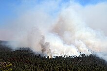
틴더 파이어
Tinder Fire| 틴더 파이어 | |
|---|---|
 2018년 4월 30일 틴더 파이어 | |
| 위치 | 미국 애리조나주 코코니노 국유림 |
| 좌표 | 34°33'29 ″N 111°09'40 ″W/34.558°N 111.161°W |
| 통계 | |
| 비용. | 750만 달러(2022년 870만 달러 equival) |
| 날짜 | 2018년 4월 27일 ~ 5월 24일 |
| 화상부위 | 16,309 에이커 (6,600 ha; 25.483 sqmi) |
| 원인 | 불법 캠프파이어 |
| 파괴된 건물 | 96 |
| 지도 | |
틴더 파이어는 2018년 4월과 5월 동안 미국 애리조나주 코코니노 국유림 1만6309에이커(6600ha)를 태운 산불입니다.화재는 2018년 4월 27일 미국 산림청(USFS) 망루에 의해 감지되었으며, 소방관들은 하루 안에 확산을 막기 위한 작업을 시작했습니다.강풍, 낮은 습도, 높은 온도의 영향을 받아, 불은 4월 말에 빠르게 증가했고, 애리조나 국도 87호선의 폐쇄와 코코니노 카운티의 1,000가구에 대한 대피령을 내렸습니다.이 주문들은 5월 4일까지 남아있었습니다.거의 700명의 소방관들이 5월 24일 완전히 진압된 화재 진압에 참여했습니다.화재 조사 결과 틴더 화재는 금지된 캠프파이어로 인해 발생한 것으로 확인됐습니다.
배경
산불은 미국 남서부 지역의 생태 순환의 자연적인 부분입니다.[1]: 3–6 틴더 파이어는 2018년 애리조나 주에서 165,356 에이커(66,917ha)를 태운 2,000건의 산불 중 하나입니다.[2]2018년 1월, 애리조나 주지사 더그 더시(Doug Ducey)는 역사적으로 건조한 겨울에 가뭄에 시달리며 2017년 산불 시즌에서 회복하고 있는 주가 2018년에 "재난적인" 산불 시즌에 직면할 수 있다고 경고했습니다.[3]틴더 파이어가 시작되었을 때, 애리조나의 모골론 림 지역의 기상 조건은 비정상적으로 건조하고 덥고 바람이 많이 불었습니다;[4][5] 4월 1일부터 이 지역에 대해 국립 기상국에 의해 네 개의 적색 깃발 경고가 발령되었습니다.[4]
불
2018년 4월 27일 오전 11시 43분(마운틴 시간),[4] 미국 산림청(USFS) 감시탑이 코코니노 국유림의 블루리지 저수지에서 동쪽으로 1.5마일(2.4km) 떨어진 킨더 크로싱 트레일 근처에서 연기가 피어오르는 것을 발견했습니다.[4][6][7]화재는 이 흔적에서 이름을 따온 것이지만, 출동자의 실수로 틴더 파이어라는 이름이 생겨 그대로 유지되었습니다.[8]하루 안에 100명의 소방관들이 틴더 파이어와 싸우기 위해 도착했고, 그 때는 150에이커의 크기였습니다.[9][10]시속 80km/h(50mph)의 바람이 불을 부채질했고, 4월 28일과 4월 29일에 걸쳐 민간 드론이 불 위를 비행하여 착륙한 소방 항공을 방해했습니다.이 급격한 성장은 애리조나 주 87번 국도(SR 87)의 폐쇄, 코코니노 카운티의 1,000가구에 대한 대피령,[11][12][13] 그리고 4월 30일 듀시에 의한 코코니노 카운티의 비상사태 선포를 촉발시켰습니다.[12]
5월 1일까지 틴더 파이어는 11,420 에이커 (4,620 ha)의 크기로 커졌고 30개의 건물을 파괴했습니다.[14][15]다음날, 비와 눈이 불의 성장을 늦추고 소방관들이 확산을 막는 데 진전을 이룰 수 있게 해주었습니다.[4][16]5월 3일까지 625명의 소방관들이 틴더 파이어 주변에서 방화선을 파고 있었습니다.[17][18]대피 명령은 5월 4일에 해제되었고, 그때까지 불은 15,841 에이커 (6,411 ha)의 면적으로 커졌지만, 79%가 진압된 것으로 여겨졌습니다.[19][20]SR 87 또한 5월 4일 대중 교통에 다시 개방되었습니다.[21][22]5월 12일까지 불은 16,309 에이커 (6,600 ha)까지 커졌지만 바람이 부는 조건에도 불구하고 더 이상 화재를 진압하지 못했습니다.[23] 5월 24일까지 당국은 95%가 진압되었다고 발표했습니다.[24]
잔상
틴더 파이어는 27일 동안 16,309 에이커(6,600 ha)를 태웠고 억제 및 진압에 750만 달러(2022년[25] 870만 달러에 해당)의 비용이 들었습니다.[26]: 9 [27]이 지역의 약 10%가 전체적인 나뭇잎 사망률을 겪었습니다.[26]: 9 틴더 파이어는 96개의 건물을 파괴했고,[27] 그 중 33개의 집과 63개의 작은 건물들이 파괴되었습니다.[26]: 9 695명의 소방관들이 불길이 최고조에 달했을 때 불길을 잡기 위해 일했습니다.[4]
USFS는 4월 27일 화재 원인 조사를 시작했고 5월 1일까지 버려진 불법 캠프파이어로 판단했습니다.USFS는 책임 있는 당사자나 당사자를 결정할 수 없었습니다.[10][15]
참고문헌
- ^ Pyne, Stephen J. (2016). The Southwest: A Fire Survey. To the Last Smoke. Vol. 4. University of Arizona Press. ISBN 978-0-8165-3448-7. JSTOR j.ctt1d41dp2. LCCN 2016004471.
- ^ "National Report of Wildland Fires and Acres Burned by State" (PDF). National Interagency Fire Center. 2018. Archived (PDF) from the original on December 21, 2022. Retrieved February 18, 2023.
- ^ Bowling, Joshua (February 22, 2018). "Ducey warns Arizona of a disastrous fire season, requests double fire prevention funding". The Arizona Republic. Archived from the original on February 23, 2023. Retrieved February 18, 2023.
- ^ a b c d e f "Tinder Fire". Coconino National Forest. United States Forest Service. Archived from the original on November 6, 2020. Retrieved January 16, 2023.
- ^ "Wildfire breaks out near Blue Ridge Reservoir". Arizona Daily Sun. April 27, 2018. Archived from the original on May 1, 2018. Retrieved January 19, 2023.
- ^ "Tinder fire continues to grow; Type I team en route". InciWeb. United States Forest Service. April 28, 2018. Archived from the original on December 17, 2018. Retrieved May 31, 2018.
- ^ "Kinder Crossing Trail No. 19". United States Forest Service. Archived from the original on July 7, 2023. Retrieved July 6, 2023.
- ^ "The Latest: Arizona fire supposed to go by another name". Regina Leader-Post. Associated Press. April 30, 2018. Archived from the original on July 3, 2023. Retrieved July 3, 2023.
- ^ Ren, Victor (April 27, 2018). "Wildfire on Mogollon Rim causes pre-evacuation notices in Northern Arizona". The Arizona Republic. Archived from the original on February 23, 2023. Retrieved January 16, 2023.
- ^ a b "Tinder Fire Update: Wildfire in East Clear Creek". InciWeb. United States Forest Service. April 27, 2018. Archived from the original on December 17, 2018. Retrieved January 16, 2023.
- ^ Burkitt, Bree (April 29, 2018). "Tinder Fire grows to 8,600 acres; residents evacuated, structures burned". The Arizona Republic. Archived from the original on February 23, 2023. Retrieved January 18, 2023.
- ^ a b Pohl, Jason (April 30, 2018). "Arizona Tinder Fire: Coconino County officials declare state of emergency". The Arizona Republic. Archived from the original on February 23, 2023. Retrieved January 18, 2023.
- ^ Burkitt, Bree (April 30, 2018). "Wildfire in Arizona grows to 13.5 square miles, burns buildings in its path". USA Today. The Arizona Republic. Archived from the original on September 24, 2021. Retrieved January 19, 2023.
- ^ "Tinder Fire grows but weather conditions improve". KGUN-TV. Associated Press. May 1, 2018. Archived from the original on July 29, 2021. Retrieved January 19, 2023.
- ^ a b Pohl, Jason (May 1, 2018). "Illegal campfire sparked 11,000-acre Arizona Tinder Fire; damage assessments continue". The Arizona Republic. Archived from the original on February 23, 2023. Retrieved January 19, 2023.
- ^ "Weather helps prevent Tinder Fire from spreading". KGUN-TV. May 2, 2018. Archived from the original on August 6, 2021. Retrieved January 19, 2023.
- ^ "Tinder Fire information: 47 structures lost in northern Arizona fire". KGUN-TV. May 3, 2018. Archived from the original on July 26, 2021. Retrieved January 20, 2023.
- ^ Pohl, Jason (May 3, 2018). "Tinder Fire: 41 structures damaged or destroyed; residents return Friday". The Arizona Republic. Archived from the original on February 23, 2023. Retrieved January 20, 2023.
- ^ Levenson, Eric; Vera, Amir (May 6, 2018). "Tinder Fire in Arizona has destroyed 33 homes and is still burning". CNN. Archived from the original on January 16, 2023. Retrieved May 31, 2018.
- ^ "Tinder Fire evacuation orders lifted for hundreds of homes". KGUN-TV. Associated Press. May 4, 2018. Archived from the original on October 1, 2022. Retrieved February 18, 2023.
- ^ "SR 87 reopened after Tinder Fire evacuation". KPNX. May 4, 2018. Archived from the original on February 20, 2023. Retrieved February 20, 2023.
- ^ "State Route 87 near Winslow re-opens as Tinder Fire continues to burn". KTAR-FM. May 4, 2018. Archived from the original on June 14, 2018. Retrieved February 20, 2023.
- ^ "Final Update: Type III team winding down, winds moving ash". InciWeb. United States Forest Service. Archived from the original on July 5, 2018. Retrieved February 20, 2023.
- ^ "Tinder Fire". InciWeb. United States Forest Service. Archived from the original on January 25, 2019. Retrieved May 30, 2018.
- ^ 1634–1699: 1700–1799: 1800–현재:
- ^ a b c Lynch, Michael; Evans, Alexander (June 2019). "2018 Wildfire Season: An Overview" (PDF). Southwestern United States. Northern Arizona University. Archived (PDF) from the original on January 19, 2022. Retrieved January 16, 2023.
- ^ a b "National Large Incident Year-to-Date Report" (PDF). National Interagency Fire Center. July 25, 2018. p. 16. Archived from the original (PDF) on July 25, 2018. Retrieved January 12, 2023.
외부 링크
 Wikimedia Commons의 Tinder Fire 관련 매체
 애리조나 포털


