로마 시
Town of Roma| 로마 시 퀸즐랜드 | |
|---|---|
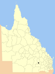
 퀸즐랜드 내 위치 | |
| 인구 | 6,906(2011년 인구조사)[1] |
| 확립된 | 1867 |
| 의회석 | 로마 |
| 지역 | 달링 다운스 |
| 웹사이트 | 로마 시 |
로마 타운은 오스트레일리아 퀸즐랜드의 다운스 서부 지역에 있는 지방 정부 지역이었다.로마 마을은 로마의 도시 지역을 덮었고, 이웃한 방길의 샤이어에게 둘러싸여 있었다.오늘날 이곳은 마라노아 지역의 일부분이다.2011년 인구조사에서 그 마을은 6,906명의[1] 인구를 가지고 있었다.
역사
1903년 3월 31일, 지방 당국법(1902)에 따라, 로마 자치구는 로마 시가 되었다.[2]
2007년 7월, 지방정부개혁위원회는 퀸즐랜드의 지방정부 지역을 다수 합병할 것을 권고하는 보고서를 발표했다.그 결과, 2007년 「지방자치법(개혁시행)」에 따라, 2008년 3월 15일, 이전 5개 지방정부 지역을 통합하여 로마 지역의 새로운 지방정부 지역이 조성되었다.[2][3]
2009년 7월 26일 로마 지역은 마라노아 지방으로 개칭되었다.[3]
시장
- 1867: T. 맥이웬[4]
- 1902: T.A. 스펜서[5]
- 1906: R. 콘란
- 제임스 랄러, 퀸즐랜드 입법회의 및 퀸즐랜드 입법회의[7] 위원
- 1927: 조지 파워 윌리엄스
- 리처드 제임스 코텔 (두 번)
- 2000-2008: 브루스 가비[10]
참조
- ^ a b Australian Bureau of Statistics (31 October 2012). "2011 Community Profiles: Roma (T) (Local Government Area)". 2011 Census of Population and Housing. Retrieved 4 October 2016.
- ^ a b c "Agency ID 2460, Roma Town Council". Queensland State Archives. Retrieved 22 January 2014.
- ^ a b "Agency ID 11033, Maranoa Regional Council". Queensland State Archives. Retrieved 5 September 2013.
- ^ Spencer, Hope (22 April 1948). "Roma: Its Growth and Development" (PDF). Historical Society of Queensland, Inc. Retrieved 22 January 2014.
- ^ Consolidated Index to Queensland Government Gazette 1859-1919. Queensland Family History Society. 2004. ISBN 1 876613 79 3.
- ^ "Queensland Mayors and Shire Chairmen". The Queenslander. 24 February 1906. p. 22. Retrieved 1 October 2015 – via National Library of Australia.
- ^ "Lalor, James". Re-Member Database. Queensland Parliament. Retrieved 18 June 2014.
- ^ Pugh, Theophilus Parsons (1927). Pugh's Almanac for 1927. Retrieved 13 June 2014.
- ^ Welch, Melva A, (compiler.); Toowong and District Historical Society (issuing body) (2013), Cradle to grave – Toowong Council, Toowong, [Queensland] Toowong and District Historical Society, ISBN 978-0-9872487-0-1
{{citation}}: CS1 maint : 복수이름 : 작성자 목록(링크) - ^ "The Councillors". Roma Town Council. Archived from the original on 30 August 2007. Retrieved 22 January 2014.
외부 링크
- 퀸즐랜드 지방정부 기획부 – 지방정부 디렉토리.
- "Roma". Queensland Places. Centre for the Government of Queensland, University of Queensland.


