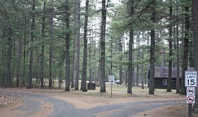
블랙 리버 주립 숲
Black River State Forest| 블랙 리버 주립 숲 | |
|---|---|
IUCN 범주 V(보호된 가로/세로) | |
 야영장 입구 | |
| 위치 | 미국 위스콘신 주 잭슨 |
| 가장 가까운 도시 | 위스콘신 주 블랙 리버 폭포 |
| 좌표 | 44°18′29″N 90°37′27″w / 44.30806°N 90.62417°W좌표: 44°18′29″N 90°37′27″W / 44.30806°N 90.62417°W/ |
| 면적 | 67,070에이커(271.4km2) |
| 확립된 | 1957 |
| 통치기구 | 위스콘신 천연자원부 |
| 웹사이트 | https://dnr.wi.gov/topic/StateForests/blackRiver/ |
블랙리버 스테이트 포레스트(Black River State Forest)는 미국 위스콘신 주 블랙리버폴스(Black River Falls) 인근 위스콘신 주 잭슨 카운티 서부에 위치한 주립 숲이다. 위스콘신 천연자원부에서 관리하고 있다. 그 공원에는 야영지와 산책로가 있고 사냥, ATV, 카누를 탈 수 있다.[1] 위스콘신 주의 드리프트리스 지역 가장자리에 있으며, 카운티의 동쪽 절반에서 발견되는 것보다 더 험준하다.[2]
환경관리
매년, 약 1000 에이커의 공원에 있는2 숲이 벌목으로 사용된다. 선택적 절단을 통해 숲의 재생을 위해 통나무를 수확한다.[3]
2015년과 2016년 고라니들이 공원에 재도입됐다.[1]
참조
- ^ a b "Black River State Forest". dnr.wi.gov. Wisconsin Department of Natural Resources. April 19, 2019. Retrieved 2019-04-22.
- ^ Ed Anderson, Karen Anderson. "4" (PDF). Regional Assessment of the Wisconsin Driftless Natural Division (Report). Wisconsin Department of Natural Resources. pp. 50–52. Archived from the original (PDF) on 2007-08-10. Retrieved 2019-04-22.CS1 maint: 작성자 매개변수 사용(링크)
- ^ Black River State Forest Visitor Guide 2016 (Guide Pamphlet). Wisconsin Department of Natural Resources. 2016. Retrieved 2019-04-22.
외부 링크


