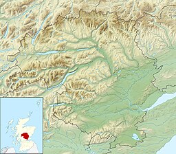
검은 호수(퍼스와 킨로스)
Black Loch (Perth and Kinross)| 검은 호수 | |
|---|---|
 Blairgowrie 인근 Carsie의 Black Loch | |
| 위치 | NO175427 |
| 좌표 | 56°34°09°N 3°20′36″w/56.569100°N 3.343300°W좌표: 56°34°09°N 3°20°36°W / 56.569100°N 3.343300°W / |
| 유형 | 담수호 |
| 최대 길이 | 0.402km(0.250mi)[1] |
| 최대 폭 | 0.1609km(0.1000mi)[1] |
| 표면적 | 2.6ha(6.4에이커)[2] |
| 평균 깊이 | 1.45 [1]m (4.75 피트) |
| 최대 깊이 | 7 피트 (2.1 m)[1] |
| 용수량 | 1,611,000 cuft (45,6003 m)[1] |
| 해안1 길이 | 0.8km(0.50mi) |
| 지표면 표고 | 51 m (160 피트)[2] |
| 최고 온도 | 60.1 °F (15.6 °C) |
| 최저 온도 | 57.4 °F (14.1 °C) |
| 섬들 | 0 |
| 1 쇼어 길이는 명확하게 정의된 측정값이 아닙니다. | |
블랙 로치는 루난 번 계곡에 있는 핑거스크 호 바로 동쪽에 위치한 작은 저지대 담수호이며 퍼스와 [1][2]킨로스에 있는 블레어고우리에서 남쪽으로 1마일 떨어져 있다.
이 호수는 또한 특별 보존 [3]구역의 일부를 형성할 뿐만 아니라 특별 과학적 관심 장소(SSSI)로 지정되어 있다.
지리
Black Loch는 다른 두 개의 작은 꽃의 동쪽에 있습니다.바로 동쪽은 White Loch이고, 더 동쪽은 여전히 핑거스크 호로 반 마일 거리 안에 있습니다.White Loch의 동쪽 끝과 Black Loch의 모든 부분이 Blairgowrie Golf [4]Club의 경계 내에 있습니다.
「 」를 참조해 주세요.
레퍼런스
- ^ a b c d e f John, Murray; Lawrence, Pullar. Bathymetrical Survey of the Fresh-Water Lochs of Scotland, 1897-1909 Lochs of the Tay Basin Volume II - Black Loch. National Library of Scotland. p. 109. Retrieved 18 June 2019.
 이 문서에는 퍼블릭 도메인에 있는 이 소스로부터의 텍스트가 포함되어 있습니다.
 - ^ a b c d "Black Loch". British Lakes. Retrieved 18 June 2019.
- ^ Dunkeld - Blairgowrie Lochs, Joint Nature Conservation Committee
- ^ Gittings, Bruce; Munro, David. "Black Loch, Perth and Kinross". The Gazetteer for Scotland. School of GeoSciences, University of Edinburgh and The Royal Scottish Geographical Society. Retrieved 18 June 2019.


