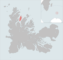
생란 그라몬트 주
Île Saint-Lanne Gramont 케르겔렌 제도의 올레 생란 그라몬트 | |
| 지리 | |
|---|---|
| 위치 | 인도양 |
| 좌표 | 48° 55° 32° S 69° 10° 46° E |
| 군도 | 델레스 케르겔렌 |
| 전체 섬 | 1 |
| 주요 섬 | 생란 그라몬트 주 |
| 면적 | 45.8km2(17.7제곱 mi) |
| 면적 순위 | 5일(케르겔렌 제도에서) |
| 길이 | 16km(9.9mi) |
| 폭 | 6km(3.7mi) |
| 해안선 | 43.5km(27.03mi) |
| 최고 고도 | 473m(1552ft) |
| 최고점 | 몽맥코믹 |
| 관리 | |
| 구 | 델레스 케르겔렌 |
| 인구통계학 | |
| 데모네임 | 생란 그라몬테 |
| 인구 | 0 |
생란 그라몬트 섬은 무인도(無道)로, 프레스퀼 드 라 소시에 드 제오그래피 북쪽에 위치한 케르굴렌 제도에서 네 번째로 큰 섬으로 면적은 45.28km이다. 최고점인 480m에 이르며, 위치한다. 48°55′25″S 69°10′54″E / 48.92361°S 69.18167°E/ 18167좌표: 48°55′25″S 69°10′54″E / 48.92361°S 69.18161°E/ , . 이 섬은 남북 축을 따라 길게 늘어섰으며 최대 길이 13km, 최대 폭 3km에 이른다. 소개된 동물이 없다.
중요 조류 영역
The island, along with the neighbouring, and relatively large, islands of Île Foch and Île Howe, as well as the smaller Île MacMurdo, Île Briand, Îles Dayman and Îlots Hallet, has been identified by BirdLife International as an Important Bird Area (IBA) because of its value as a breeding site, especially for seabirds, with at least 29 species nestiIBA의 ng.[1]
참조
- ^ 버드라이프 인터내셔널. (2012). 중요한 조류 지역 자료: le레 포흐, le레 사인 그라몬트, î레 하우. 2012-01-21에 http://www.birdlife.org에서 다운로드.


