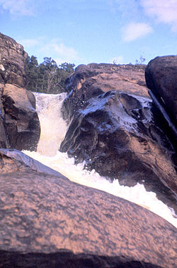
툴리 폭포
Tully Falls| 툴리 폭포 | |
|---|---|
 1959년 툴리 폭포 | |
| 위치 | 멀리 오스트레일리아 북부 퀸즐랜드 |
| 좌표 | 17°47′00″S 145°34′00″E/17.78333°S 145.56667°E좌표: 17°47′00″S 145°34′00″E / 17.78333°S 145.56667°E[1][2] |
| 유형 | 고추냉이 |
| 표고 | 673m(2,208ft) AHD |
| 총 높이 | 180–190m(590–690ft)[4] |
| 드롭 수 | 1 |
| 수로, 운하 | 툴리 강 |
툴리 강에 있는 고추장 폭포인 툴리 폭포는 호주 퀸즐랜드의 극북 지역에 있는 유네스코 세계문화유산 등재된 습열대에 위치해 있다.다이르발의 동쪽 경계를 이루었다.
위치 및 기능
해발 673m(2,208ft)[3]의 아더튼 테이블랜드에서 180~210m(590~690ft)[4]의 폭포가 라벤쇼 마을 인근 툴리 협곡 국립공원으로 내려온다.폭포는 1.6km(0.99mi) 등급의 트랙을 통해 접근할 수 있다.[5]
그렇지 않았더라면 폭포 위로 흘러갔을 대부분의 물은 카레이야 수력발전소로 우회되어 쿰불룸바 댐에 의해 댐이 되었다.그 결과, 낙하는 큰 우기에만 흐른다.[5]
참고 항목
참조
- ^ "Tully Falls (QLD)". Gazetteer of Australia online. Geoscience Australia, Australian Government.
- ^ "Tully Falls (entry 35300)". Queensland Place Names. Queensland Government. Retrieved 13 September 2015.
- ^ a b "Map of Tully Falls, QLD (the town)". Bonzle Digital Atlas of Australia. Retrieved 30 May 2014.
- ^ a b "Tully Falls". World Waterfall Database. 21 May 2011. Retrieved 30 May 2014.
- ^ a b "Things to Do Tully Falls". Wet Tropics Management Authority. Archived from the original on 17 September 2008. Retrieved 29 January 2008.


