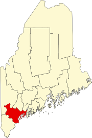
스탠디시(CDP), 메인 주
Standish (CDP), Maine메인 주 스탠디시 | |
|---|---|
 | |
| 좌표: 43°44′7″N 70°33′9″w / 43.73528°N 70.55250°W | |
| 나라 | 미국 |
| 주 | 메인 주 |
| 카운티 | 컴벌랜드 |
| 마을 | 스탠디시 |
| 면적 | |
| • 합계 | 2.7 sq mi(6.9 km2) |
| • 육지 | 2.7 sq mi(6.9 km2) |
| • 물 | 0.0 sq mi(0.0 km2) |
| 표고 | 433 ft (103 ft) |
| 인구 (2010) | |
| • 합계 | 469 |
| • 밀도 | 180/sq mi(68/km2) |
| 시간대 | UTC-5(동부(EST)) |
| • 여름(DST) | UTC-4(EDT) |
| 지역 번호 | 207 |
스탠디시(Standish Corner)는 미국 메인주 컴벌랜드 카운티의 스탠디시(Standish) 마을에 있는 인구조사 지정 장소(CDP)이다.[1] 2010년 인구 조사에서 인구는 469명이었다.[2] 포틀랜드의 일부다.사우스 포틀랜드-비데포드, 메인 메트로폴리탄 통계 지역.
지리
스탠디시(Standish)는 43°44°7 atN 70°3에 위치한다.3′9″W / 43.73528°N 70.55250°W/ (43.7353, -70.5525), 메인 주 고속도로 25번과 35번 교차로에서.[3] 25번 국도는 뉴햄프셔를 향해 서쪽으로, 고럼과 포틀랜드를 향해 동쪽으로 달리고, 35번 국도는 노스윈드햄을 향해 북쪽으로, 남으로는 벅스턴, 홀리스, 그리고 결국 케네벙크까지 운행한다.
미국 인구조사국에 따르면, 스탠디시 CDP의 총 면적은 2.7 평방마일(6.9km2)이며, 모든 땅이다.[4]
참조
- ^ "Standish Corner Village Design Master Plan" (PDF). Town of Standish. 2007. Retrieved June 14, 2012.
- ^ "Profile of General Population and Housing Characteristics: 2010 Demographic Profile Data (DP-1): Standish CDP, Maine". United States Census Bureau. Retrieved June 14, 2012.
- ^ "US Gazetteer files: 2010, 2000, and 1990". United States Census Bureau. 2011-02-12. Retrieved 2011-04-23.
- ^ "Geographic Identifiers: 2010 Demographic Profile Data (G001): Standish CDP, Maine". United States Census Bureau. Retrieved June 14, 2012.


