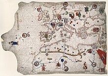
살바토레 데 필레스트리나
Salvatore de Pilestrina살바토레 데 필레스트리나 fl.(1502–1533)는 살바트 데 필레스트리나라고도 하며 16세기 초 말로르카의 지도 제작자였다.
학자들은 그가 이탈리아 태생이었다고 주장하는데, 부분적으로 그의 작품이 그 시대의 이탈리아와 카탈루냐 지도 제작 기술을 결합했기 때문이다.[1][2]그는 그곳에서 지도학을 공부하기 위해 이탈리아에서 말로르카로 여행했을 것이다.[3]
그의 알려진 활동 기간은 1502년에서 1533년까지이다.[4][5]
필레스트리나는 포르톨란 차트 작업으로 유명하며, 메이저칸 지도학교에서 활동했다.[6][4][5]그는 몇 개의 중요한 지중해 지도를 만들었는데, 이 지도들의 원조는 사라졌다.[1]그는 또한 중앙아메리카의 대서양 연안의 지도를 포함하여 아메리카 대륙으로 뻗어나간 많은 지도들을 제작한 것으로 생각된다.[7][8]
그의 첫 번째 알려진 차트는 1503년 경에 제작된 주요 세계지도였다.[3][9][10]다른 알려진 작품들은 1504년 또는 1505년,[11] 1511년,[12][13] 1533년에 제작되었다.[1][4][14]다른 지도들이 그에게 귀속된 반면, 그 기원은 역사가들에 의해 논쟁되고 있다.[15]
참조
- ^ a b c Astengo, Corradino (1987). "The Renaissance Chart Tradition in the Mediterranean". In Harley, J. B.; Woodward, David; Monmonier, Mark S. (eds.). The History of Cartography (PDF). Vol. 3. Chicago: University of Chicago Press. ISBN 0-226-31633-5. OCLC 13456456.
- ^ Winter, Heinrich (1947-01-01). "On the real and the Pseudo‐Pilestrina maps and other early‐Portuguese maps in Munich". Imago Mundi. 4 (1): 25–27. doi:10.1080/03085694708591877. ISSN 0308-5694.
- ^ a b Bagrow, Leo; Skelton, R.A. History of cartography (Enlarged second ed.). London. ISBN 978-1-351-51558-0. OCLC 995849708.
- ^ a b c "Portolan chart by Salvat de Pilestrina". Ziereis Facsimiles. Retrieved 2021-02-08.
{{cite web}}: CS1 maint : url-status (링크) - ^ a b Rey Pastor, Julio; García Camarero, Ernesto (1959). La Cartografía Mallorquína (PDF) (in Spanish). Departamento de Historia y Filosofía de la Ciencia Instituto Luis Vives Consejo Superior de Investigaciones Científicas.
- ^ "Salvatore de Pilestrina (14..-1511)". Bibliothèque nationale de France (in French). Retrieved 2021-02-08.
{{cite web}}: CS1 maint : url-status (링크) - ^ "[Atlantic coast of Central America]". Library of Congress. Retrieved 2021-02-08.
{{cite web}}: CS1 maint : url-status (링크) - ^ Lewis, Bessie Mary (1936). "Darient – A Symbol of Defiance and Achievement". The Georgia Historical Quarterly. 20 (3): 185–198. ISSN 0016-8297.
- ^ Paltsits, Victor Hugo; Stevenson, Edward Luther (July 1905). "Maps Illustrating Early Discovery and Exploration in America, 1502-1530". The American Historical Review. 10 (4): 863. doi:10.2307/1834492. ISSN 0002-8762.
- ^ List of Maps of the World: Illustrating the Progress of Geographical Knowledge from the Earliest Times to the End of the Seventeenth Century. New York Public Library. 1904.
- ^ Heawood, Edward (1923). "A Hitherto Unknown World Map of A. D. 1506". The Geographical Journal. 62 (4): 279–293. doi:10.2307/1781021. ISSN 0016-7398.
- ^ Boinet, A. (1925). "Courrier de France". La Bibliofilía. 27 (1/2): 61–71. ISSN 0006-0941.
- ^ Van Duzer, Chet (2007). "Cartographic Invention: The Southern Continent on Vatican MS Urb. Lat. 274, Folios 73v-74r (c.1530)". Imago Mundi. 59 (2): 193–222. ISSN 0308-5694.
- ^ "[Carta de marear del mar Mediterráneo]". Biblioteca Nacional de España (in Spanish). Retrieved 2021-02-08.
{{cite web}}: CS1 maint : url-status (링크) - ^ Winsor, Justin (1884). Narrative and critical history of America, ed. by Justin Winsor.


