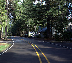
오리건 주 레인보우
Rainbow, Oregon오리건 주 레인보우 | |
|---|---|
 레인보우의 도로와 구조물 | |
| 좌표: 44°10′1″n 122°14′14″w / 44.16694°N 122.23722°W | |
| 나라 | 미국 |
| 주 | 오리건 주 |
| 카운티 | 차선 |
| 표고 | 1,211ft(369m) |
| 시간대 | UTC-8(태평양(PST)) |
| • 여름(DST) | UTC-7(PDT) |
레인보우는 미국 오리건 주 레인카운티에 있는 비법인 공동체다. 그것은 유진 북동쪽 오리건 126번 국도에 있다. 레인보우의 높이는 1211피트(369m)이다.[1] 1924년 7월 1일 우체국이 설립되어 1937년 8월 31일 문을 닫았다. 우체국은 맥켄지 강에서 헤엄치는 무지개 송어로부터 그 이름을 얻었다.[2][3]
참조
- ^ "Rainbow". Geographic Names Information System. United States Geological Survey. November 28, 1980. Retrieved August 3, 2011.
- ^ McArthur, Lewis A.; McArthur, Lewis L. (2003) [1928]. Oregon Geographic Names (7th ed.). Portland, Oregon: Oregon Historical Society Press. p. 796. ISBN 978-0875952772.
- ^ "Names of Lane County Communities Reveal Interesting Histories, Anecdotes". Eugene Register-Guard. 4 January 1942. p. 4. Retrieved 23 April 2015.


