남부 오스트레일리아 푸나카
Pooraka, South Australia| 푸르나카 사우스 오스트레일리아 애들레이드 | |||||||||||||||
|---|---|---|---|---|---|---|---|---|---|---|---|---|---|---|---|
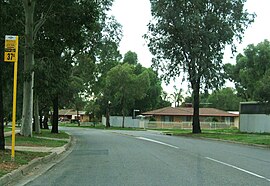
 푸르야카의 거리 | |||||||||||||||
| 좌표 | 34°49′28″s 138°37′37″E / 34.82444°S 138.62694°E좌표: 34°49′28″S 138°37′37″E / 34.82444°S 138.62694°E/ | ||||||||||||||
| 인구 | 7,196(2016년 인구조사)[1] | ||||||||||||||
| 우편번호 | 5095 | ||||||||||||||
| 위치 | 애들레이드 도심 12km(7mi) N | ||||||||||||||
| LGA | 솔즈베리 주의 도시 | ||||||||||||||
| 주 선거인단 | 플로리 | ||||||||||||||
| 연방 부서 | 마킨 | ||||||||||||||
| |||||||||||||||
푸냐카는 사우스 오스트레일리아 애들레이드에 있는 교외다. 중앙 상권에서 북쪽으로 12킬로미터 떨어져 있다.
역사
푸냐카는 원래 겟스 크로스의 그랜드 정션 로드에서 몬태규 로드 북쪽 지점까지 이어지는 야탈라 백작의 97절을 분할한 것이었다.[2] 본래는 지방 수도원(Dry Creek)의 이름을 따서 Dry Creek으로 알려졌는데, 지금은 푸르냐카 서쪽에 있는 근대 공업 지역 이름이다(Dry Creek, South Australia주, Dry Creek). 1916년 야탈라 지방 의회는 '건조하다'[2]는 뜻의 토착적인 카우르나 낱말인 것으로 [citation needed]여겨졌던 교외 푸르나카(Furnaka)로 이름을 바꾸었지만, 현대 전문가 로버트 아메리에 따르면 이 명칭은 '건조하다'나 'creek'를 뜻하는 카우르나 낱말과 전혀 유사하지 않다고 한다. 이 용어는 남호주에서는 찾아볼 수 없는 테르베틴 나무의 뉴사우스웨일스 토착 이름으로 확인되었다.[3]
푸사카 동부우체국은 1965년 12월 1일 문을 열고 1986년 문을 닫았다.[4] 노스필드 철도 노선의 철도역(초기에는 아바토이르스라고 알려졌으나, 후에 푸사카로 개칭)은 1913년부터 1987년 5월 29일에 폐쇄되기 전까지 운행되었다.[5]
참조
- ^ Australian Bureau of Statistics (27 June 2017). "Pooraka". 2016 Census QuickStats. Retrieved 15 September 2020.

- ^ a b "Search result for 'Pooraka, SUB'". Property Location Browser. Government of South Australia. SA0056423. Retrieved 13 September 2017.
Derivation of Name: Abna meaning dry; Other Details: Originally a private subdivision of Section 97. A request from the South Australian Housing Trust to alter a portion of the suburb to Montague Farm was not approved by the Minister for the Environment & Natural Resources on 10/10/1995. Portion of suburb included in 1998 into the suburb of Mawson Lakes. Portion excluded from the suburb of Cavan and added to the suburb of Pooraka on 14 September 2006.
- ^ Amery, Rob (March 2009), "Chapter 18. Reclaiming through renaming: The reinstatement of Kaurna toponyms in Adelaide and the Adelaide plains" (PDF), in Hercus, Luise; Hodges, Flavia; Simpson, Jane (eds.), The Land is a Map: Placenames of Indigenous Origin in Australia, ANU Press, pp. 255–276, ISBN 978-1-921536-57-1, retrieved 11 August 2013,
Pooraka is [a] puzzling case. 'In 1916 the Yatala District Council discarded the name "Dry Creek" as applied to the old post office, in favour of Pooraka, a native word meaning "dry creek'" (Cockburn 1908:56; 1990:63) while Praite and Tolley (1970:148) say it means 'dry waterhole', also found in Endacott (1955:48), a source which draws primarily on Victorian materials. The origins of Pooraka are obscure. It bears no resemblance to documented Kaurna words for 'dry' or 'creek'. Yet it was named at a time before the appearance of books promoting the use of Aboriginal words from anywhere and everywhere. Perhaps it was in fact the original name for the Dry Creek watercourse itself. However, Pooraka does appear in Ingamells (1955) and Reed (1967) with the same spelling, where it is identified as a New South Wales word meaning 'turpentine tree'.
- ^ "Post Office List: Pooraka East Post Office". Premier Postal History. Premier Postal Auctions. Retrieved 13 September 2017.
- ^ "ATDB • View topic - 150th Anniversary of the Stockade (Northfield) Line". busaustralia.com. Retrieved 21 September 2017.


