포메라페
Pomerape| 포메라페 | |
|---|---|
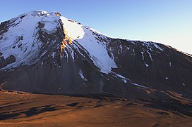
 남쪽(Parinacota 경사면)에서 본 포머레이프 및 아래 안장 | |
| 최고점 | |
| 표고 | 6,282m (20,102ft)[1] |
| 두각을 나타남 | 950m(3,120ft) |
| 격리 | 4km(2.5mi) |
| 좌표 | 18°07′33″S 69°07′39″W / 18.12583°S 69.12750°W |
| 지리 | |
| 상위 범위 | 안데스 |
| 지질학 | |
| 암석시대 | 플리스토세 |
| 산형 | 스트라토볼카노 |
| 등반 | |
| 가장 쉬운 경로 | 눈/얼음 등반 |
포메라페는 칠레 북부와 볼리비아 국경(사자마 주 오루로 주, 쿠라후아라 데 카랑가스 시)에 놓여 있는 스트라토볼카노이다.[2] 남쪽으로는 파이나코타 화산(Parinacota Volcano)과 함께 화산(Payachata) 단지의 일부다. "Payachata"라는 이름은 "twins"를 의미하며 그들의 외모를 가리킨다.[3] 그것은 북쪽 경사면에서 더 낮은 5,300–5,800 미터 (17,400–19,000 피트)의 고도까지 빙하를 수용한다.[4]
포메라페는 용암 돔의 복합체로, 용암 흐름을 동반하며 돔의 꼭대기에 배치되었다.[5] 그것은 약 20만년 전에 활동했다.[6] 용암 돔이 먼저 형성되었고 나중에 실제 화산 원뿔에 의해 매장되었는데, 이 원뿔은 라임체-다카틱 돔과 달리 뿔블렌드 안데시테에 의해 형성된다.[7] 이때 '천가라 안데스이트'와 파리나코타의 용암돔 단지가 놓여 있었다.[8] 포메라페는 마피크 마그마를 분출시킨 재림 환기구와 관련이 있다. 메인 콘은 106,000 +- 7,000년 전에 마지막으로 활성화되었으며,[9] 재림 환기구 연대는 205,000 ± 2만 4,000년 전이다.[10]
화산을 오르는 것은 동쪽 능선 옆의 고산급 PD이다.[11] 더 단단한 경로는 남쪽 면에 존재하며, 때로는 50도 이상의 눈/허벅지 경사면에 존재한다. 이러한 경로의 경우, 파리나코타와 포메라페 사이의 안장에 5,300m(17,390ft)에서 캠프를 설치할 수 있다. 계절에 따라 주요 난관은 참회(높은 아이스블레이드 바늘)가 될 수 있어 등반을 물리적으로 어렵거나 불가능하게 만든다.
참고 항목
참조
- ^ 칠레 IGM 고도 2007-09-27 웨이백 기계에 보관
- ^ 쿠라후라 데 카랑가스 시의 지도와 인구 자료 웨이백 머신에 보관된 2014-11-11
- ^ Schull, William J. (1990). "Introduction: The Place and the Study". In Schull, William J.; Rothhammer, Francisco (eds.). The Aymara. Studies in Human Biology. 2. Springer Netherlands. pp. 1–18. doi:10.1007/978-94-009-2141-2_1. ISBN 9789401074636.
- ^ Carrasco, Jorge F.; Osorio, Roberto; Casassa, Gino (2008-07-01). "Secular trend of the equilibrium-line altitude on the western side of the southern Andes, derived from radiosonde and surface observations". Journal of Glaciology. 54 (186): 545. Bibcode:2008JGlac..54..538C. doi:10.3189/002214308785837002.
- ^ Gonzalez-Ferran, Oscar (1994). Volcanes de Chile (in Spanish) (1st ed.). Santiago, Chile: Instituto geografico militar. p. 113. ISBN 9789562020541.
- ^ Wörner, Gerhard; Moorbath, Stephen; Horn, Susanne; Entenmann, Jürgen; Harmon, Russel S.; Davidson, Jon P.; Lopez-Escobar, Leopoldo (1994). Reutter, Professor Dr Klaus-Joachim; Scheuber, Dr Ekkehard; Wigger, Dr Peter J. (eds.). Tectonics of the Southern Central Andes. Springer Berlin Heidelberg. p. 81. doi:10.1007/978-3-642-77353-2_5. ISBN 9783642773556.
- ^ Wörner, G.; Harmon, R. S.; Davidson, J.; Moorbath, S.; Turner, D. L.; McMillan, N.; Nyes, C.; Lopez-Escobar, L.; Moreno, H. (1988-09-01). "The Nevados de Payachata volcanic region (18°S/69°W, N. Chile)" (PDF). Bulletin of Volcanology. 50 (5): 287–303. Bibcode:1988BVol...50..287W. doi:10.1007/BF01073587. hdl:2027.42/47805. ISSN 0258-8900.
- ^ Hora, J. M.; Singer, B. S.; Worner, G. (2007). "Volcano evolution and eruptive flux on the thick crust of the Andean Central Volcanic Zone: 40Ar/39Ar constraints from Volcan Parinacota, Chile". Geological Society of America Bulletin. 119 (3–4): 343–362. Bibcode:2007GSAB..119..343H. doi:10.1130/b25954.1.
- ^ Wörner, Gerhard; Hammerschmidt, Konrad; Henjes-Kunst, Friedhelm; Lezaun, Judith; Wilke, Hans (2000-12-01). "Geochronology (40Ar/39Ar, K-Ar and He-exposure ages) of Cenozoic magmatic rocks from Northern Chile (18-22°S): implications for magmatism and tectonic evolution of the central Andes". Revista Geológica de Chile. 27 (2): 205–240. ISSN 0716-0208.
- ^ Gonzalez-Ferran, Oscar (1994). Volcanes de Chile (1st ed.). Santiago, Chile: Instituto geografico militar. p. 113. ISBN 9789562020541.
- ^ Biggar, John (2020). The Andes - A Guide for Climbers and Skiers (5th ed.). Scotland: Andes. p. 192. ISBN 978-0-9536087-6-8.
- "Parinacota". Global Volcanism Program. Smithsonian Institution. (포머레이프 포함)


