피오 5. 말뭉치
Pio V. Corpus피오 5. 말뭉치 림부한 | |
|---|---|
| 피오 5세 말뭉치 | |
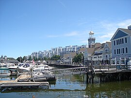
 발랑기 섬 해변 | |
| 좌우명: 가르보나톤 마스바테뇨 키타 아랑카다 말뭉치 | |
 피오 V. 말뭉치가 강조 표시된 마스바테 지도 | |
오픈스트리트맵  | |
.svg) 피오 5. 말뭉치 필리핀 내 위치 | |
| 좌표: 11°53'01ºN 124°02'59ºE / 11.8836°N 124.0497°E / | |
| 나라 | 필리핀 |
| 지역 | 비콜 주 |
| 지방 | 마스바테 |
| 구 | 제3지구 |
| 창립 | 1951년 6월 11일 |
| 바랑가이 | 18(바랑가이 참조) |
| 정부 | |
| 유형 | 상구니앙바얀 주 |
| 시장 | 앨런 T.레파사나 |
| 부시장 | 로자베스 M. 타요 |
| 대표자 | 윌튼 T. 코 |
| 시의회 | 회원들 |
| 유권자 | 17,200명의 유권자(투표자) |
| 지역 | |
| 총계 | 89.33km2(34.49sqmi) |
| 승진 | 38m(125ft) |
| 최고 고도 | 240m(790ft) |
| 최저 고도 | 0m(0ft) |
| 인구. (2020년 인구조사)[3] | |
| 총계 | 23,744 |
| 밀도 | 270/km2(690/sqmi) |
| 가구 | 5,960 |
| 경제. | |
| 소득계층 | 제4시 소득계층 |
| 빈곤율 | 29.74 |
| 수익 | 1억 20만(2020년) |
| 자산 | 1억 8,280만 (2020년) |
| 지출 | 1억 840만 명(2020년) |
| 부채 | 3994만 (2020년) |
| 서비스 제공업체 | |
| 전기 | 마스바테 전기 협동조합(MASELCO) |
| 시간대 | UTC+8(PST) |
| 우편번호 | 5406 |
| PSGC | |
| IDD : 지역번호 | +63 (0)56 |
| 모국어 | 세부아노 마스바테뇨 타갈로그어 |
피오 V. 코퍼스, 공식적으로 피오 V. 코퍼스 지방 자치체는 필리핀 마스바테 주의 4급 지방 자치체입니다.2020년 기준으로 이 지역의 인구 수는 총 23,[3]744명입니다.
역사
피오 V. 코퍼스는 이전에 림부한으로 알려져 있었습니다.1951년, 림부한, 긴다와한, 팔호, 카사방간, 살바시온, 알레그리아, 탄케, 분두칸, 부통, 그리고 카방그라얀의 바리오들이 카타잉안 마을에서 분리되어 림부한 [5]마을로 만들어졌습니다.이 마을은 1954년에 현재의 이름을 받았고 전 국회의원이자 주지사인 피오 비얄루즈 코퍼스 (1883–1944)의 이름을 따서 지어졌습니다.1883년 7월 11일 누에바 에치자에서 태어난 그는 마스바테로 이주했고 나중에 전쟁 기간에 일본이 후원하는 정부에서 복무할 예정이었고 1944년 2월 7일 마닐라에서 불신으로 인해 불행하게도 일본 정보부에 의해 암살되었습니다.초대 시장은 다니엘 [6]세뇨론이었습니다.
지리학
바랑가이

피오 5세 말뭉치는 정치적으로 18개의 바랑가이로 세분됩니다. [7] 각각의 바랑가이는 푸록들로 구성되어 있고 일부는 시티오를 가지고 있습니다.
시티오 부강은 [8]1957년에 바리오로 개조되었습니다.
- 알레그리아
- 부에나수에르테
- 부강
- 부통
- 분두칸
- 카방그레이안
- 칼롱곤간
- 카사방간
- 긴다와한
- 라비건
- 람푸양
- 마부헤이
- 팔호
- 포블라시온
- 살바시온
- 탄케
- 투비건
- 투보그
기후.
| Pio V. Corpus, Masbate에 대한 기후 데이터 | |||||||||||||
|---|---|---|---|---|---|---|---|---|---|---|---|---|---|
| 달 | 얀 | 2월 | 3월 | 4월 | 그럴지도 모른다 | 준 | 7월 | 8월 | 9월 | 10월 | 11월 | 12월 | 연도 |
| 평균 최고 °C(°F) | 29 (84) | 29 (84) | 31 (88) | 32 (90) | 32 (90) | 31 (88) | 30 (86) | 30 (86) | 30 (86) | 30 (86) | 29 (84) | 29 (84) | 30 (86) |
| 평균 최저 °C(°F) | 23 (73) | 22 (72) | 23 (73) | 23 (73) | 25 (77) | 25 (77) | 24 (75) | 25 (77) | 24 (75) | 24 (75) | 24 (75) | 23 (73) | 24 (75) |
| 평균 강수량 mm(인치) | 39 (1.5) | 34 (1.3) | 42 (1.7) | 36 (1.4) | 73 (2.9) | 109 (4.3) | 118 (4.6) | 108 (4.3) | 129 (5.1) | 136 (5.4) | 112 (4.4) | 89 (3.5) | 1,025 (40.4) |
| 평균 비오는 날 | 12.6 | 9.7 | 12.0 | 13.0 | 20.5 | 25.3 | 26.2 | 24.8 | 25.2 | 25.9 | 21.9 | 17.9 | 235 |
| 출처: 메테오블루[9] | |||||||||||||
인구통계학
|
| |||||||||||||||||||||||||||||||||||||||
| ||||||||||||||||||||||||||||||||||||||||
| 출처: 필리핀 통계청[10][11][12][13] | ||||||||||||||||||||||||||||||||||||||||
2020년 인구 조사에서 피오 5세 코퍼스의 인구는 23,[3]744명이었고, 밀도는 평방 킬로미터 당 270명 또는 평방 마일 당 700명이었습니다.
경제.
참고 항목
레퍼런스
- ^ 피오 5세 말뭉치 (DILG)
- ^ "2015 Census of Population, Report No. 3 – Population, Land Area, and Population Density" (PDF). Philippine Statistics Authority. Quezon City, Philippines. August 2016. ISSN 0117-1453. Archived (PDF) from the original on May 25, 2021. Retrieved July 16, 2021.
- ^ a b c Census of Population (2020). "Region V (Bicol Region)". Total Population by Province, City, Municipality and Barangay. Philippine Statistics Authority. Retrieved 8 July 2021.
- ^ "PSA Releases the 2018 Municipal and City Level Poverty Estimates". Philippine Statistics Authority. 15 December 2021. Retrieved 22 January 2022.
- ^ "An Act Creating the Municipality of Limbuhan in the Province of Masbate". LawPH.com. Retrieved 2011-04-09.
- ^ "An Act Changing the Name of the Municipality of Limbuhan, Province of Masbate to Pio V. Corpus". LawPH.com. Retrieved 2011-04-11.
- ^ "Province: Masbate". PSGC Interactive. Quezon City, Philippines: Philippine Statistics Authority. Retrieved 12 November 2016.
- ^ "An Act Converting the Sitio of Bugang in the Municipality of Pio V. Corpus, Province of Masbate, into a Barrio to Be Known As Barrio Bugang". LawPH.com. Retrieved 2011-04-12.
- ^ "Pio V. Corpus: Average Temperatures and Rainfall". Meteoblue. Retrieved 23 June 2020.
- ^ Census of Population (2015). "Region V (Bicol Region)". Total Population by Province, City, Municipality and Barangay. Philippine Statistics Authority. Retrieved 20 June 2016.
- ^ Census of Population and Housing (2010). "Region V (Bicol Region)". Total Population by Province, City, Municipality and Barangay. National Statistics Office. Retrieved 29 June 2016.
- ^ Censuses of Population (1903–2007). "Region V (Bicol Region)". Table 1. Population Enumerated in Various Censuses by Province/Highly Urbanized City: 1903 to 2007. National Statistics Office.
- ^ "Province of Masbate". Municipality Population Data. Local Water Utilities Administration Research Division. Retrieved 17 December 2016.
- ^ "Poverty incidence (PI):". Philippine Statistics Authority. Retrieved December 28, 2020.
- ^ "Estimation of Local Poverty in the Philippines" (PDF). Philippine Statistics Authority. 29 November 2005.
- ^ "2003 City and Municipal Level Poverty Estimates" (PDF). Philippine Statistics Authority. 23 March 2009.
- ^ "City and Municipal Level Poverty Estimates; 2006 and 2009" (PDF). Philippine Statistics Authority. 3 August 2012.
- ^ "2012 Municipal and City Level Poverty Estimates" (PDF). Philippine Statistics Authority. 31 May 2016.
- ^ "Municipal and City Level Small Area Poverty Estimates; 2009, 2012 and 2015". Philippine Statistics Authority. 10 July 2019.
- ^ "PSA Releases the 2018 Municipal and City Level Poverty Estimates". Philippine Statistics Authority. 15 December 2021. Retrieved 22 January 2022.
외부 링크