델라웨어 주 오마르
Omar, Delaware델라웨어 주 오마르 | |
|---|---|
 | |
| 좌표: 38°31′38″N 75°11′59″w / 38.52722°N 75.19972°W좌표: 38°31′38″N 75°11′59″W / 38.52722°N 75.19972°W | |
| 나라 | 미국 |
| 주 | 델라웨어 주 |
| 카운티 | 서섹스 주 |
| 시간대 | UTC-5(동부(EST)) |
| • 여름(DST) | UTC-4(EDT) |
| GNIS 피쳐 ID | 216170[1] |
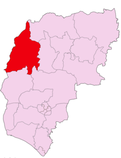
오마르는 미국 델라웨어주 서섹스 카운티의 비법인 공동체로 델라웨어 20번 국도(아모리 로드/파일 센터 로드)와 서섹스 카운티 54번 도로(오마르 로드)의 교차로에 위치하고 있으며, 다그스보로와 록사나의 마을 사이에 있다.[1]
볼티모어 밀스 역사 고고학 유적지는 1997년에 국립 사적지 목록에 추가되었다.[3]
참조
- ^ a b "Omar". Geographic Names Information System. United States Geological Survey.
- ^ Gannett, Henry (1904), A Gazetteer of Delaware (Issue 230 of Geological Survey bulletin), U.S. Government Printing Office
- ^ "National Register Information System". National Register of Historic Places. National Park Service. July 9, 2010.


