북입로역사지구
North Entrance Road Historic District북입로역사지구 | |
 | |
  | |
| 가장 가까운 도시 | 몬타나 와이오밍 주 옐로우스톤 국립공원 |
|---|---|
| 좌표 | 45°0′24″n 110°41′58″w/45.00667°N 110.69944°W좌표: 45°0′24″N 110°41′58″W / 45.00667°N 110.69944°W |
| 빌드됨 | 1883 |
| 건축가 | COE |
| MPS | 옐로우스톤 국립공원 MPS |
| NRHP 참조 | 02000529 및 02000530 |
| NRHP에 추가됨 | 2002년[1] 5월 22일 |
북진입로역사지구는 몬태나주 가디너에서 와이오밍주 매머드 온천에 있는 공원 본부로 이어지는 옐로우스톤 국립공원의 북진도로로 구성돼 있다.북입로는 공원 내 최초의 주요 도로로, 가디너 북태평양 철도역까지 옐로우스톤 요새의 미군기지와 합류하는데 필요한 도로였다.이 도로에는 공원 북쪽 경계에 있는 루즈벨트 아치가 포함되며, 가드너 강을 건너 그랜드 루프 로드에 합류하기 전에 구르는 지형을 통해 바람이 분다.[2]이 도로는 1883년 미 육군 공병대의 댄 킹맨 중위가 계획했고 이후 히람 M 대위가 개선했다. 군단의 치텐덴,[3][4]그것은 강의 서쪽 능선을 넘어 북쪽의 매머드 호텔 뒤에서 가디너 마을로 가는 옛 가디너 하이 로드를 대체했다.공원 진입 차량을 점검하기 위한 주택 경비원의 첫 번째 영구입구역은 1921년에 건설되었다.루즈벨트 아치에서 경비대가 사용하던 임시 텐트를 대체했다.[5]
북진로는 미국 89년도의 미서명 지역이다.
북입로역사지구 이미지

가드너 강 횡단, 1901년
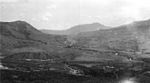
로어 가드너 강, 1923년

가드너 강을 가로지르는 그랜드 루프 다리

도로의 북쪽 끝에 있는 북태평양 철도역.

1904년 매머드로 가는 스테이지코치

매머드의 무대코치
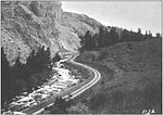
로어 가드너 강길, 1912년

북입구역, 1922년

북입구역, 1936년

신북입구역, 1938년

북입구역, 1949년

1990년 북입구역


참고 항목
추가 읽기
- Culpin, Mary Shivers (1994). The History of the Construction of the Road System of Yellowstone National Park 1872-1966 (Report). National Park Service.
메모들
- ^ "National Register Information System". National Register of Historic Places. National Park Service. April 15, 2008.
- ^ "North Entrance Road Historic District". National Register of Historic Places. Wyoming State Preservation Office. 2008-10-01.
- ^ Marcy Shivers Culpin; Christine Whitacre; Catherine Lentz; Lon Johnson (2001). "National Register of Historic Places Inventory-Nomination: North Entrance Road Historic District" (pdf). National Park Service.
{{cite journal}}:Cite 저널은 필요로 한다.journal=(도움말) - ^ Bartlett, Richard A. (1989). Yellowstone-A Wilderness Besieged. Tucson, AZ: University of Arizona Press. pp. 75–80. ISBN 0-8165-1098-9.
- ^ Culpin, Mary Shivers (1994). The History of the Construction of the Road System of Yellowstone National Park 1872-1966 (Report). National Park Service. p. 299.
외부 링크
| 위키미디어 커먼즈에는 북입로역사지구와 관련된 미디어가 있다. |
- HAER(Historic American Engineer Record) No. MT-93, "북진입로, MT & 매머드 온천, WY, 가디너 인근, 파크 카운티, MT", 컬러 투명도 1개, 데이터 페이지 11개, 사진 캡션 페이지 1개
- HAER No. WY-7, "Gardner River Bridge, Spanning Gardner River, WYE, Lake, Teton County, North Incent Road, Spanning Gardner River, WY, 12장, 측정 도면 3장, 데이터 페이지 9장, 사진 캡션 페이지 1장
- 국립공원 서비스 영상 - 구 가디너 도로
- 와이오밍 주 역사보존소 북입로 역사지구
옐로우스톤 국립공원 - 매머드 온천 | ||
|---|---|---|
매머드 온천 지역의 역사적 건축물 및 기타 명소 | ||
| 구조물들 그리고 역사 |  | |
| 지리 지질학 및 지질학 | ||
| ||