만카얀
Mankayan만카얀 | |
|---|---|
| 만카얀 시 | |
| 모토: 벤게트의 북쪽 미래 | |
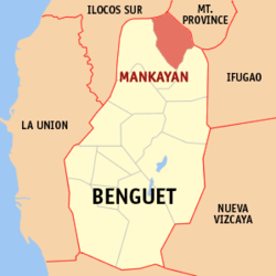
 만카얀이 강조 표시된 벤게트 지도 | |
필리핀 내 위치 | |
| 좌표: 16°52°N 화씨 120도 47도 / 16.87°N 120.78°E좌표: 16°52′N 120°47′E / 16.87°N 120.78°E/ ° | |
| 나라 | 필리핀 |
| 지역 | 코딜레라 행정구 |
| 주 | 벵게트 |
| 구 | 론 구 |
| 설립됨 | 1955 |
| 바랑게이 | 12(바랑게이 참조) |
| 정부 | |
| • 유형 | 상무니앙바얀 |
| • 시장 | Frenzel A. 아용 |
| • 부시장 | 조셉 덴버 B. 통가칸 |
| • 대표 | 네스토르 B. 퐁완 |
| • 유권자 | 유권자 20,852명(2019년) |
| 면적 | |
| • 합계 | 130.48km2(50.38제곱 mi) |
| 표고 | 1,338m(4,380ft) |
| 최고 고도 | 2,214m(7,264ft) |
| 최저 고도 | 666m(2,520ft) |
| 인구 (1998년 인구조사) | |
| • 합계 | 37,233 |
| • 밀도 | 290/km2(740/sq mi) |
| • 가구 | 8,062 |
| 이코노미 | |
| • 소득계층 | 제1차 시 소득계층 |
| • 빈곤 발생 | 9.34% (2015)[4] |
| • 수익 | ₱175,268,339.49 (2020) |
| • 자산 | ₱334,594,585.92 (2020) |
| • 지출 | ₱170,584,450.59 (2020) |
| • 부채 | ₱28,917,760.34 (2020) |
| 서비스 제공업체 | |
| • 전기 | 벤게트전기협동조합(BENECO) |
| 시간대 | UTC+8(PST) |
| 우편번호 | 2608 |
| PSGC | |
| IDD : 지역번호 | +63 (0)74 |
| 네이티브 언어 | 칸카나이 이발로이 일로카노 타갈로그어 |
만카얀(Mankayan)은 공식적으로 만카얀(Kankanaey: 일린 디 만카얀; 일로카노: 일리 ti Mankayan, Tagalog: 바얀 ng 만카얀)은 필리핀 벵게트 지방의 1급 자치단체다. 2020년 인구조사에 따르면 인구는 3만7233명이다. [3]
이 시군은 레판토 통합 광산 회사를 포함한 몇 개의 광산이 위치한 광산 도시로 알려져 있다.[5][6]
어원
'만카얀'이라는 이름은 그곳의 원주민 이름인 낭카양( (k山)의 히스패닉 용어인 '난카얀(南ancan)'에서 유래되었다.[5][6]
역사
식전 기간
낭카양은 한때 숲이 우거진 지역이었다. 파나트와 백온간의 주변 정착촌 원주민들은 강에서 금을 발견했다는 보고가 있은 후, 연구실을 통해 금을 채굴했다. 구리는 16세기 말까지 카망가안(현재의 레판토의 위치)에서 발견되었다.[6]
스페인 시대
1800년대까지 스페인 식민지 정부는 광산을 조사하기 위해 탐험대를 보냈다. 1850년 2월 3일, 엔지니어 돈 안토니오 에르난데스가 이끄는 탐험대가 만카얀에 구리의 존재를 확인했다.
1852년, 레판토는 만카얀을 포함한 여러 장의 장로들로 구성된 코만반시아의 정치-무용수로 스페인인에 의해 설립되었다.[6][7][5]
만카얀-수요크 지역에서는 페드로 듀란 데 몬포르테 제독의 1667년 원정 때 7개의 서로 다른 광산이 발견되었으며, 시몬 데 안다 행정(1770~1776)은 이고로트 동기를 언급했다. 1833년 갈베이는 감방("코퍼"), 수요크(Suyoc), 만카얀(Mankayan)의 광석 샘플을 총독에게 보냈다. 코딜레라에 대한 최초의 스페인 광산 주장은 1856년 3월 26일 토마스 발바스 이 카스트로(Tomas Balbas y Castro)에 의해 이루어졌으며,[8] 소시에다드 미네로-메탈루기차 칸타브로 필리핀인 드 만카얀(Sokedad Minero-Metalurgica Kantabro Pilipian de Mancayan)이라는 광산회사를 설립하였다.[5] 그 회사는 1875년에 영업을 중단했다.[6]
미국 시대
미국의 지배하에 만카얀은 르판토의 관할하에 있었고, 이후 르판토-본토크는 후자가 해산할 때까지 계속 레판토-본토크의 관할하에 있었다. 만카얀은 이후 1913년 자치구로서 벤게트 하위 도에 병합되었다.[5][6]
만카얀의 광산 붐은 1933년 미국인 빅터 레드니키가 1936년 9월 26일 레판토 통합 광산 회사를 설립하면서 시작되었다.[5][6]
제2차 세계 대전
전쟁 발발 후인 1942년, 레판토 통합 채굴회사가 수요크 통합 채굴회사와 함께 일본 미쓰이 채굴회사에 인수되어 광산을 '미쓰이 만카얀 구리 광산'으로 개칭하였다. 미쓰이 회사는 1945년까지 광산을 통제했다.[5][6][9]
전후 시대
전쟁이 끝난 후, 레판토 통합 채굴 회사는 채굴 작업을 재개했다.[5][6]
만카얀은 공화국법 1302호로 1955년 6월 16일 자치구에서 일반 자치구로 전환되었다.[10][11]
2018년 만카이안 원로들의 고도로 예술적인 갱사 만들기 무형유산을 보존하기 위해 마을의 문화 대가들이 모여 젊은 세대들에게 갱사 만들기의 과정과 중요성을 그들의 생활 방식에 가르치기 시작함으로써 마을의 토착적인 공 문화를 효과적으로 보존하였다.[12]
지리
만카얀은 벵게트의 북서쪽 끝에 있다. 서쪽은 바쿤, 남동쪽은 부귀아스, 동쪽은 타디안과 바우코, 북서쪽은 세르반테스와 접한다.
필리핀 통계청에 따르면, 이 자치단체는 130.48 평방 킬로미터(50.38 평방 미터)의 토지 면적이 벤게트 전체 면적 2,769.08 평방 킬로미터(1,069.15 평방 미터)의 4.71%를 차지한다.
바랑게이
만카얀은 정치적으로 12개의 바랑게이로 세분되어 있다.[14]
| PSGC | 바랑게이 | 인구 | ±% p.a. | |||
|---|---|---|---|---|---|---|
| 2020 [3] | 2010 [15] | |||||
| 141111001 | 발릴리 | 17.6% | 6,537 | 6,236 | 0.45% | |
| 141111002 | 침대 | 2.8% | 1,058 | 864 | 1.94% | |
| 141111003 | 불랄라카오 | 8.6% | 3,205 | 3,349 | −0.42% | |
| 141111004 | 카비텐 | 5.7% | 2,129 | 1,854 | 1.32% | |
| 141111005 | 콜랄로 | 3.4% | 1,268 | 1,232 | 0.27% | |
| 141111006 | 과이나오앙 | 6.0% | 2,249 | 1,855 | 1.84% | |
| 141111008 | 파코 | 15.4% | 5,744 | 6,035 | −0.47% | |
| 141111009 | 팔라산 | 6.3% | 2,358 | 2,348 | 0.04% | |
| 141111010 | 포블라시온 | 6.9% | 2,572 | 3,084 | −1.71% | |
| 141111011 | 사피드 | 8.6% | 3,218 | 3,271 | −0.15% | |
| 141111012 | 타비오 | 10.4% | 3,855 | 3,792 | 0.16% | |
| 141111013 | 타네그 | 4.7% | 1,760 | 1,666 | 0.52% | |
| 합계 | 37,233 | 35,586 | 0.43% | |||
기후
| 만카얀, 벤게트 기후 데이터 | |||||||||||||
|---|---|---|---|---|---|---|---|---|---|---|---|---|---|
| 월 | 얀 | 2월 | 3월 | 4월 | 5월 | 준 | 줄리 | 8월 | 9월 | 10월 | 11월 | 12월 | 연도 |
| 평균 높은 °C(°F) | 20 (68) | 22 (72) | 23 (73) | 25 (77) | 24 (75) | 24 (75) | 23 (73) | 23 (73) | 23 (73) | 23 (73) | 22 (72) | 21 (70) | 23 (73) |
| 평균 낮은 °C(°F) | 13 (55) | 14 (57) | 15 (59) | 17 (63) | 18 (64) | 18 (64) | 18 (64) | 18 (64) | 18 (64) | 17 (63) | 16 (61) | 15 (59) | 16 (61) |
| 평균 강수량 mm(인치) | 35 (1.4) | 46 (1.8) | 63 (2.5) | 117 (4.6) | 402 (15.8) | 400 (15.7) | 441 (17.4) | 471 (18.5) | 440 (17.3) | 258 (10.2) | 94 (3.7) | 68 (2.7) | 2,835 (111.6) |
| 평균 비 오는 날 | 9.9 | 11.1 | 13.9 | 18.9 | 26.0 | 27.3 | 28.9 | 28.5 | 26.1 | 19.7 | 14.5 | 12.8 | 237.6 |
| 출처: 마테오블루 | |||||||||||||
인구통계학
| 연도 | Pop. | ±% p.a. |
|---|---|---|
| 1903 | 118 | — |
| 1918 | 2,977 | +24.01% |
| 1939 | 6,865 | +4.06% |
| 1948 | 5,742 | −1.97% |
| 1960 | 13,812 | +7.59% |
| 1970 | 21,780 | +4.65% |
| 1975 | 24,123 | +2.07% |
| 1980 | 25,684 | +1.26% |
| 1990 | 32,889 | +2.50% |
| 1995 | 34,699 | +1.01% |
| 2000 | 34,502 | −0.12% |
| 2007 | 34,563 | +0.02% |
| 2010 | 35,586 | +1.07% |
| 2015 | 35,953 | +0.20% |
| 2020 | 37,233 | +0.69% |
| 출처: 필리핀 통계청 | ||
2020년 인구조사에서 만카얀의 인구는 37,233명이었다. [3] 인구 밀도는 평방 킬로미터 당 290명의 주민이었다.
이코노미
| 만카얀의 빈곤발생 현황 | |
| 출처: 필리핀 통계청[20][21][22][23][24][25] | |
교육
공립학교
만카얀은 2014년 현재 공립 초등학교 35곳과 공립 중등학교 9곳이 있다.[26][27][28]
|
|
참조
- ^ 만카얀 시 (DILG)
- ^ "2015 Census of Population, Report No. 3 – Population, Land Area, and Population Density" (PDF). Philippine Statistics Authority. Quezon City, Philippines. August 2016. ISSN 0117-1453. Archived (PDF) from the original on May 25, 2021. Retrieved July 16, 2021.
- ^ a b c d Census of Population (2020). "Cordillera Administrative Region (CAR)". Total Population by Province, City, Municipality and Barangay. PSA. Retrieved 8 July 2021.
- ^ https://psa.gov.ph/sites/default/files/City%20and%20Municipal-level%20Small%20Area%20Poverty%20Estimates_%202009%2C%202012%20and%202015_0.xlsx; 발행일: 2019년 7월 10일; 출판사: 필리핀 통계청.
- ^ a b c d e f g h "Municipality of Mankayan". Province of Benguet (official website). Retrieved 6 January 2015.
- ^ a b c d e f g h i "Municipality of Mankayan, Benguet". Department of the Interior and Local Government - Cordillera Administrative Region (official website). 29 April 2013. Archived from the original on 6 February 2015. Retrieved 6 January 2015.
- ^ "History: Benguet Province". Province of Benguet (official website). Archived from the original on 19 October 2014. Retrieved 6 January 2015.
- ^ Scott, William (1974). The Discovery of the Igorots. Quezon City: New Day Publishers. pp. 57–60, 245–246. ISBN 9711000873.
- ^ Bagamaspad, Anavic; Hamada-Pawid, Zenaida (1985). A People's History of Benguet. Baguio Printing & Publishing Company, Inc. p. 299.
- ^ "R.A. No. 1302: An Act to Convert the Municipal District of Mankayan, Sub-province of Benguet, Mountain Province, into a Municipality". Chan Robles Virtual Law Library. Retrieved 6 January 2015.
- ^ "R.A. No. 1302: An Act to Convert the Municipal District of Mankayan, Sub-province of Benguet, Mountain Province, into a Municipality". PhilippineLaw.info. Retrieved 6 January 2015.
- ^ http://pia.gov.ph/news/articles/1004356
- ^ "Province: Benguet". PSGC Interactive. Quezon City, Philippines: Philippine Statistics Authority. Retrieved 12 November 2016.
- ^ "Municipal: Mankayan". PSGC Interactive. Quezon City, Philippines: Philippine Statistics Authority. Retrieved 8 January 2016.
- ^ a b Census of Population and Housing (2010). "Cordillera Administrative Region (CAR)". Total Population by Province, City, Municipality and Barangay. NSO. Retrieved 29 June 2016.
- ^ "Mankayan: Average Temperatures and Rainfall". Meteoblue. Retrieved 21 March 2020.
- ^ Census of Population (2015). "Cordillera Administrative Region (CAR)". Total Population by Province, City, Municipality and Barangay. PSA. Retrieved 20 June 2016.
- ^ Censuses of Population (1903–2007). "Cordillera Administrative Region (CAR)". Table 1. Population Enumerated in Various Censuses by Province/Highly Urbanized City: 1903 to 2007. NSO.
- ^ "Province of Benguet". Municipality Population Data. Local Water Utilities Administration Research Division. Retrieved 17 December 2016.
- ^ "Poverty incidence (PI):". Philippine Statistics Authority. Retrieved 28 December 2020.
- ^ https://psa.gov.ph/sites/default/files/NSCB_LocalPovertyPhilippines_0.pdf; 발행일: 2005년 11월 29일; 출판사: 필리핀 통계청.
- ^ https://psa.gov.ph/sites/default/files/2003%20SAE%20of%20poverty%20%28Full%20Report%29_1.pdf; 발행일: 2009년 3월 23일; 출판사: 필리핀 통계청.
- ^ https://psa.gov.ph/sites/default/files/2006%20and%202009%20City%20and%20Municipal%20Level%20Poverty%20Estimates_0_1.pdf; 발행일: 2012년 8월 3일; 출판사: 필리핀 통계청.
- ^ https://psa.gov.ph/sites/default/files/2012%20Municipal%20and%20City%20Level%20Poverty%20Estima7tes%20Publication%20%281%29.pdf; 발행일: 2016년 5월 31일; 출판사: 필리핀 통계청.
- ^ https://psa.gov.ph/sites/default/files/City%20and%20Municipal-level%20Small%20Area%20Poverty%20Estimates_%202009%2C%202012%20and%202015_0.xlsx; 발행일: 2019년 7월 10일; 출판사: 필리핀 통계청.
- ^ "Masterlist of Public Elementary Schools for the School year 2012- 2013". Department of Education (Philippines), July 15, 2013. Archived from the original (XLSX) on 4 March 2016. Retrieved 28 December 2014.
- ^ a b "Masterlist of Secondary Schools (School Year 2013- 2014)". Department of Education (Philippines), July 4, 2013. Archived from the original (XLSX) on 1 July 2014. Retrieved 20 November 2014.
- ^ a b "Masterlist of Public Schools SY 2013-2014". Department of Education (Philippines), 22 October 2014. Archived from the original (XLSX) on 21 April 2016. Retrieved 28 December 2014.


