마달레나 고개
Maddalena Pass| 마달레나 고개 | |
|---|---|
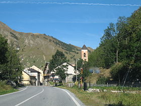
 마달레나 고개 근처의 아르젠테라 마을 | |
| 표고 | 1,996m(6,549ft) |
| 위치 | 프랑스 알페스데하우테 프로방스 / 이탈리아 쿠네오 주 |
| 범위 | 코티안 알프스와 해양 알프스 |
| 좌표 | 44°25′18″N 6°53′55″E / 44.42167°N 6.89861°E좌표: 44°25′18″N 6°53′55″E / 44.42167°N 6.89861°E/ 6 |
마달레나 고개(이탈리아어: 콜레 델라 마달레나 프랑스어: 콜 드 라르체, 역사적으로 콜 드 라르체(Colle de L'Argentiere) (Elevation 1996 m.)는 코티안 알프스와 이탈리아와 프랑스의 경계에 위치한 해양 알프스 사이의 높은 산 고개다. 프랑스의 바르셀로네트와 이탈리아의 쿠네오를 연결한다. 프랑스어 이름 Coll de Larche는 북서쪽에 있는 마을 Larche를 가리킨다.
Under its earlier name, Col de l'Argentière it has historically linked Lyon with Italy; the Col de l'Argentière was in the possession of the house of Savoy from 1388 to 1713, offering an easy route between Piedmont and its outlying valley of Barcelonnette, which came into Savoyard possession in 1388, when Amadeus VI of Savoy purchased it for the su6만 에쿠스의 m,[1] 그것은 전략적이고 상업적인 중요성이 있었다.
고갯길에서 몇 백 미터 떨어진 이탈리아 쪽에는 타나로의 중요한 지류인 스투라 디 데몬테의 근원이 되는 라고 델라 마달레나(Lago della Maddalena)가 있다.
참고 항목
참조
- ^ W. A. B. Coolidge, "1518년 알프스 산맥의 통로" 영어사적 평론 제30호 (1915년 10월:681~691) pp 687-88, 690.
외부 링크
| 위키미디어 커먼즈에는 콜레 델라 마달레나 관련 매체가 있다. |


