아이다호의 가장 긴 하천 목록
List of longest streams of Idaho
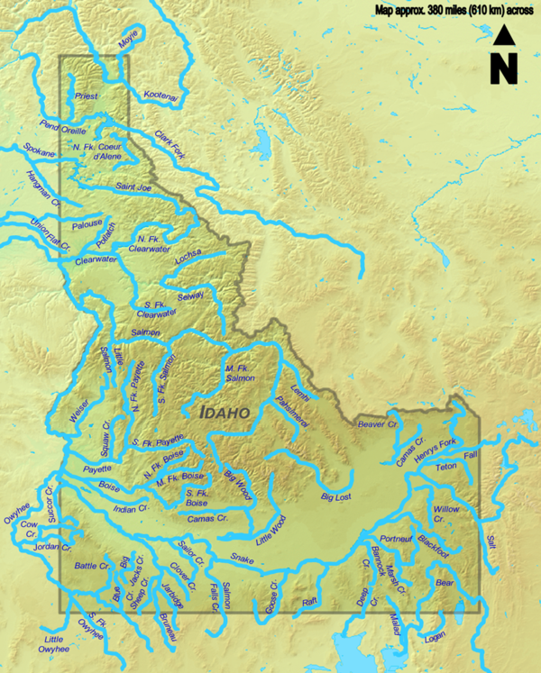
미국 아이다호 주(州)를 통해 최소 80km(약 50km) 길이의 총 70개의 하천이 흐른다.이 모든 하천은 캐나다 브리티시 컬럼비아주에서 시작되는 쿠테나이 강(가장 긴 3번째)과 모이에 강(가장 긴 30번째 가장 긴 강)을 제외한 미국에서 발원한다.스네이크 강은 1,732 킬로미터로 총 길이가 500 마일 이상인 가장 길고 유일한 하천이다.와이오밍에서 시작해 아이다호를 통해 769마일(1,238km)을 흐른 뒤 오레곤과 워싱턴을 통과한다.다른 하천들 중 일부는 아이다호와 몬태나, 네바다, 오레곤, 유타, 워싱턴, 와이오밍 주 사이에 국경을 넘기도 하지만, 대다수는 전적으로 아이다호 내에서 흐르는데, 그 중 가장 긴 곳은 684km(425마일)의 연어 강이다.
비록 강 자체가 아이다호를 통해 흐르지는 않지만, 4개를 제외한 모든 하천이 컬럼비아 강의 큰 분지 안에 놓여 있다.결과적으로, 주의 흐름의 지배적인 방향은 북서쪽으로 컬럼비아 강과 태평양의 하구를 향해 있다.아이다호에서 유일한 다른 주요 배수 유역은 그레이트 솔트 호수 남동쪽 구석에 있는 분수령으로, 그레이트 솔트 호수의 일부분이며 바다로 나가는 배출구가 없다.두 번째로 긴 하천인 베어 강은 말라드 강, 딥 크리크, 로건 강과 함께 이 분수령 안에 있다.
아래 표의 출처 데이터는 미국 지질조사국이 만들고 TopoQuest가 온라인에 게재한 지형 지도와 아이다호 도로 및 레크리에이션 아틀라스, 국립수력그래피 데이터 집합, 지리 이름 정보 시스템 및 기타 출처에서 제공된다.표에서 총 길이는 마일(mi)과 킬로미터(km)로 주어진다.
테이블


지도
참고 항목
메모들
참조
- ^ United States Geological Survey. United States Geological Survey Topographic Map (Topographic map). Reston, VA: United States Geological Survey – via TopoQuest.
- ^ 벤치마크 맵 2010.
- ^ a b 스트림 길이는 달리 명시되지 않은 한 NHD(National Hydrography Dataset)의 고해상도 유동선 데이터에서 파생된다.아이다호 NHD 데이터는 여기에서[permanent dead link] 다운로드할 수 있다(453MB zip 파일).
- ^ a b 구강 좌표, 구강 고도, 원천 좌표는 쿠테나이 강(캐나다 지형도)과 모이에 강(캐나다 지명 데이터 베이스)을 제외한 각 하천에 대한 지리적 이름 정보 시스템(미국 지질 조사 시스템) 목록이다.
- ^ "Snake River". Geographic Names Information System. United States Geological Survey. September 10, 1979. Retrieved August 6, 2010.
- ^ "Bear River". Geographic Names Information System. United States Geological Survey. December 31, 1979. Retrieved January 29, 2012.
- ^ "Rivers". Atlas of Canada. October 25, 2010. Archived from the original on January 22, 2013. Retrieved July 17, 2013.
- ^ "Kootenai River". Geographic Names Information System. United States Geological Survey. Retrieved April 15, 2011.
- ^ 캐나다 지형 지도 데이터를 사용하여 Google 어스에서 파생된 소스 좌표.
- ^ "Salmon River". Geographic Names Information System. United States Geological Survey. June 21, 1979. Retrieved January 29, 2012.
- ^ "Owyhee River". Geographic Names Information System. United States Geological Survey. November 28, 1980. Retrieved August 13, 2010.
- ^ "Clark Fork". Geographic Names Information System. United States Geological Survey. June 21, 1979. Retrieved April 19, 2011.
- ^ "Palouse River". Geographic Names Information System. United States Geological Survey. September 10, 1979. Retrieved April 24, 2011.
- ^ "Bruneau River". Geographic Names Information System. United States Geological Survey. June 21, 1979. Retrieved February 17, 2012.
- ^ "Saint Joe River". Geographic Names Information System. United States Geological Survey. June 21, 1979. Retrieved July 2, 2012.
- ^ "Big Wood River". Geographic Names Information System. United States Geological Survey. June 21, 1979. Retrieved February 17, 2012.
- ^ "Big Lost River". Geographic Names Information System. United States Geological Survey. June 21, 1979. Retrieved February 18, 2012.
- ^ "Blackfoot River". Geographic Names Information System. United States Geological Survey. June 21, 1979. Retrieved February 18, 2012.
- ^ "North Fork Clearwater River". Geographic Names Information System. United States Geological Survey. June 21, 1979. Retrieved April 28, 2011.
- ^ "Little Wood River". Geographic Names Information System. United States Geological Survey. June 21, 1979. Retrieved February 18, 2012.
- ^ "Henrys Fork". Geographic Names Information System. United States Geological Survey. June 21, 1979. Retrieved July 8, 2012.
- ^ "South Fork Owyhee River". Geographic Names Information System. United States Geological Survey. June 21, 1979. Retrieved February 18, 2012.
- ^ "Portneuf River". Geographic Names Information System. United States Geological Survey. June 21, 1979. Retrieved July 8, 2012.
- ^ "Goose Creek". Geographic Names Information System. United States Geological Survey. June 21, 1979. Retrieved August 17, 2012.
- ^ "Salmon Falls Creek". Geographic Names Information System. United States Geological Survey. June 21, 1979. Retrieved February 18, 2012.
- ^ "Pend Oreille River". Geographic Names Information System. United States Geological Survey. Retrieved April 19, 2011.
- ^ "Spokane River". Geographic Names Information System. United States Geological Survey. September 10, 1979. Retrieved April 19, 2011.
- ^ "Raft River". Geographic Names Information System. United States Geological Survey. June 21, 1979. Retrieved July 8, 2012.
- ^ "Middle Fork Salmon River". Geographic Names Information System. United States Geological Survey. June 21, 1979. Retrieved July 2, 2012.
- ^ "North Fork Payette River". Geographic Names Information System. United States Geological Survey. June 21, 1979. Retrieved July 2, 2012.
- ^ "Weiser River". Geographic Names Information System. United States Geological Survey. June 21, 1979. Retrieved July 2, 2012.
- ^ "Boise River". Geographic Names Information System. United States Geological Survey. June 21, 1979. Retrieved July 2, 2012.
- ^ "South Fork Boise River". Geographic Names Information System. United States Geological Survey. June 21, 1979. Retrieved July 2, 2012.
- ^ "Selway River". Geographic Names Information System. United States Geological Survey. June 21, 1979. Retrieved July 2, 2012.
- ^ "Jordan Creek". Geographic Names Information System. United States Geological Survey. November 28, 1980. Retrieved August 28, 2010.
- ^ "Malad River". Geographic Names Information System. United States Geological Survey. December 31, 1979. Retrieved July 2, 2012.
- ^ "Big Malad Spring". Geographic Names Information System. United States Geological Survey. June 21, 1979. Retrieved July 22, 2013.
- ^ "Moyie River". Geographic Names Information System. United States Geological Survey. June 21, 1979.
- ^ "Moyie River". BC Geographical Names. Retrieved April 16, 2011.
- ^ "South Fork Salmon River". Geographic Names Information System. United States Geological Survey. June 21, 1979. Retrieved July 4, 2012.
- ^ "Willow Creek". Geographic Names Information System. United States Geological Survey. June 21, 1979. Retrieved August 17, 2012.
- ^ "Salt River". Geographic Names Information System. United States Geological Survey. June 5, 1979. Retrieved July 4, 2012.
- ^ "Payette River". Geographic Names Information System. United States Geological Survey. December 31, 1992. Retrieved July 4, 2012.
- ^ "Teton River". Geographic Names Information System. United States Geological Survey. June 21, 1979. Retrieved July 5, 2012.
- ^ "South Fork Payette River". Geographic Names Information System. United States Geological Survey. June 21, 1979. Retrieved July 5, 2012.
- ^ "Hangman Creek". Geographic Names Information System. United States Geological Survey. September 10, 1979. Retrieved April 22, 2011.
- ^ "North Fork Coeur d'Alene River". Geographic Names Information System. United States Geological Survey. May 1, 1991. Retrieved July 5, 2012.
- ^ "Clearwater River". Geographic Names Information System. United States Geological Survey. June 21, 1979. Retrieved April 25, 2011.
- ^ "Deep Creek". Geographic Names Information System. United States Geological Survey. June 21, 1979. Retrieved July 5, 2012.
- ^ "Union Flat Creek". Geographic Names Information System. United States Geological Survey. September 10, 1979. Retrieved July 5, 2012.
- ^ "Succor Creek". Geographic Names Information System. United States Geological Survey. November 28, 1980. Retrieved August 31, 2010.
- ^ "Lochsa River". Geographic Names Information System. United States Geological Survey. June 21, 1979. Retrieved July 5, 2012.
- ^ "Priest River". Geographic Names Information System. United States Geological Survey. June 21, 1979. Retrieved August 17, 2012.
- ^ "Battle Creek". Geographic Names Information System. United States Geological Survey. June 21, 1979. Retrieved July 5, 2012.
- ^ "Bannock Creek". Geographic Names Information System. United States Geological Survey. June 21, 1979. Retrieved July 5, 2012.
- ^ "Indian Creek". Geographic Names Information System. United States Geological Survey. June 21, 1979. Retrieved July 5, 2012.
- ^ "Sailor Creek". Geographic Names Information System. United States Geological Survey. June 21, 1979. Retrieved July 7, 2012.
- ^ "Fall River". Geographic Names Information System. United States Geological Survey. December 31, 1992. Retrieved July 7, 2012.
- ^ "Camas Creek". Geographic Names Information System. United States Geological Survey. June 21, 1979. Retrieved July 7, 2012.
- ^ "Camas Creek". Geographic Names Information System. United States Geological Survey. June 21, 1979. Retrieved July 7, 2012.
- ^ "South Fork Clearwater River". Geographic Names Information System. United States Geological Survey. June 21, 1979. Retrieved April 26, 2011.
- ^ "Sheep Creek". Geographic Names Information System. United States Geological Survey. June 21, 1979. Retrieved July 7, 2012.
- ^ "Squaw Creek". Geographic Names Information System. United States Geological Survey. June 21, 1979. Retrieved July 7, 2012.
- ^ "Little Owyhee River". Geographic Names Information System. United States Geological Survey. June 21, 1979. Retrieved July 7, 2012.
- ^ "Lemhi River". Geographic Names Information System. United States Geological Survey. June 21, 1979. Retrieved July 7, 2012.
- ^ "Pahsimeroi River". Geographic Names Information System. United States Geological Survey. June 21, 1979. Retrieved July 7, 2012.
- ^ "Beaver Creek". Geographic Names Information System. United States Geological Survey. June 21, 1979. Retrieved July 8, 2012.
- ^ "Big Jacks Creek". Geographic Names Information System. United States Geological Survey. December 31, 1992. Retrieved July 8, 2012.
- ^ "Potlatch River". Geographic Names Information System. United States Geological Survey. June 21, 1979. Retrieved April 25, 2011.
- ^ "Marsh Creek". Geographic Names Information System. United States Geological Survey. June 21, 1979. Retrieved July 8, 2012.
- ^ "Clover Creek". Geographic Names Information System. United States Geological Survey. June 21, 1979. Retrieved July 8, 2012.
- ^ "Logan River". Geographic Names Information System. United States Geological Survey. June 21, 1979. Retrieved July 8, 2012.
- ^ "Blue Creek". Geographic Names Information System. United States Geological Survey. June 21, 1979. Retrieved July 8, 2012.
- ^ "Middle Fork Boise River". Geographic Names Information System. United States Geological Survey. June 21, 1979. Retrieved July 8, 2012.
- ^ "Little Salmon River". Geographic Names Information System. United States Geological Survey. June 21, 1979. Retrieved July 8, 2012.
- ^ "Jarbidge River". Geographic Names Information System. United States Geological Survey. June 21, 1979. Retrieved July 8, 2012.
- ^ "Cow Creek". Geographic Names Information System. United States Geological Survey. November 28, 1980. Retrieved September 3, 2010.
- ^ "North Fork Boise River". Geographic Names Information System. United States Geological Survey. June 21, 1979. Retrieved July 8, 2012.
인용된 작품
- Benchmark Maps (2010). Idaho Road and Recreation Atlas (Map) (2nd ed.). 1:250,000. Benchmark Maps. ISBN 978-0-929591-06-3. OCLC 567571371.
외부 링크
- 아이다호 환경품질부에서 발간한 아이다호 하천 지도
